jagdgeschwader
Chieftain
- Joined
- Nov 12, 2014
- Messages
- 20
Hi everyone, I am posting the updated and greatly-improved version of the map project I started a few years ago. I had to step away from the project for a while, but I was able to resume the project a few months ago and am posting the updated version.
Here is the original: https://forums.civfanatics.com/thre...xtremely-realistic-wwii-world-map-1-1.624505/
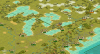
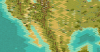
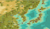
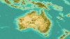
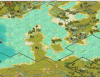
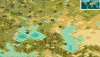
Again, the map was made for use in a WWII scenario and is thus somewhat Euro-centric. The terrain contour is incredibly realistic for a civilization scenario, but to accomplish this I had to make edits to the original terrain files using photoshop. Therefore, if you want to play the map with its full realism you will have to create a scenario folder that utilizes the terrain files included in the zip.
Notes:
-I've made edits to pretty much every continent to improve realism. Some of these are relatively minor while some are more considerable. Although the map does try to account for the natural real world topography such as elevation or climate/terrain type as much as possible, generally speaking the map values visual terrain contour above all else, and there may be a few occasionally instances where the area should technically be elevated or a different terrain type. The extent of this is rather minor and I'm guessing most people won't really care or even notice, but it is worth mentioning.
-Europe was made slightly larger for playability and the terrain realism was considerably improved.
-As someone pointed out in the last thread, the Baltic Sea and Black Sea are technically landlocked. This was intentional and was done because (a) it tends to be more aesthetically accurate from a visual standpoint and (b) it gives cities like Copenhagen and Istanbul added strategic value (the Germans have access to the Baltic through Kiel).
-The map is still incomplete. As someone else pointed out in the last few, a few of the cities are assigned to the wrong nation (for instance, the Russian city of Irkutsk is currently incorrectly assigned to Greece). This is simply because I have not yet edited these areas and they haven't been changed from the original map file; you will have to make these changes yourself.
-Some of the major transcontinental railroads across the US, Canada, and Russia are "sabotaged", which is to say they are reduced to roads in stretchs or key places whereas in real life these were rail. This is a game balance decision, these nations already have massive advantages from their size/number of cities, at it's simply meant as a minor check against this.
-Game balance is the same reason that India isn't a part of the British Commonwealth, as doing so would simply give the British an unnatural amount of power in the game.
Here is the original: https://forums.civfanatics.com/thre...xtremely-realistic-wwii-world-map-1-1.624505/
Again, the map was made for use in a WWII scenario and is thus somewhat Euro-centric. The terrain contour is incredibly realistic for a civilization scenario, but to accomplish this I had to make edits to the original terrain files using photoshop. Therefore, if you want to play the map with its full realism you will have to create a scenario folder that utilizes the terrain files included in the zip.
Notes:
-I've made edits to pretty much every continent to improve realism. Some of these are relatively minor while some are more considerable. Although the map does try to account for the natural real world topography such as elevation or climate/terrain type as much as possible, generally speaking the map values visual terrain contour above all else, and there may be a few occasionally instances where the area should technically be elevated or a different terrain type. The extent of this is rather minor and I'm guessing most people won't really care or even notice, but it is worth mentioning.
-Europe was made slightly larger for playability and the terrain realism was considerably improved.
-As someone pointed out in the last thread, the Baltic Sea and Black Sea are technically landlocked. This was intentional and was done because (a) it tends to be more aesthetically accurate from a visual standpoint and (b) it gives cities like Copenhagen and Istanbul added strategic value (the Germans have access to the Baltic through Kiel).
-The map is still incomplete. As someone else pointed out in the last few, a few of the cities are assigned to the wrong nation (for instance, the Russian city of Irkutsk is currently incorrectly assigned to Greece). This is simply because I have not yet edited these areas and they haven't been changed from the original map file; you will have to make these changes yourself.
-Some of the major transcontinental railroads across the US, Canada, and Russia are "sabotaged", which is to say they are reduced to roads in stretchs or key places whereas in real life these were rail. This is a game balance decision, these nations already have massive advantages from their size/number of cities, at it's simply meant as a minor check against this.
-Game balance is the same reason that India isn't a part of the British Commonwealth, as doing so would simply give the British an unnatural amount of power in the game.
Attachments
Last edited: