[MapScript] Erebus Continent

Seven05

Warmonger
Joined
Dec 5, 2005
Messages
2,056
Location
USA

Map generated using version 2.55 with the the new 'Deep Ocean' terrain from RiFE.
ErebusContinent
Current Version: 2.71

ErebusContinent is a map script for Fall From Heaven 2 that simulates a single continent or region. The world is generated using a detailed heightmap which is modified by plate tectonics. A climate simulation is run using this heightmap to create realistic climate zones based on the shape of the landmasses and the altitude of the heightmap. Mountain ranges follow the natural plate boundries creating detailed and beliveable mountain ranges and passes and the climate model reflects this with effects such as 'rain shadows' near mountain ranges and lush jungles or forests in areas of heavy rainfall.

Player starting locations can be based on the 'flavor' of each civilization. The Malakim will be in the desert, the Illians in the snow, the Lanun on the coast and so on. Every effort is made to ensure the starting locations are also playable and not just flavorful. This means jungles and forests will be cleared around civs that can't take advantage of them and the peaks and hills can be reduced or flattened to ensure you have enough room to grow (and the dwarves have some flat land for food). Some civilizations are also given preferences starting near other civs or off by themselves.

Player starting plot selection is still not perfect 100% of the time and it probably never will be, however as of version 2.50 it is substantially better than it has been.

Installing and using ErebusContinent.py:
Simply extract the mapscript from the attached zip file into your ...\Sid Meier's Civilization 4\Beyond the Sword\Mods\Fall from Heaven 2\PrivateMaps folder (or the private or public maps folder of your prefered FfH mod). When playing the game you will see ErebusContinent as an available map. Remember, this is a random map generator, not a static map or scenario, you can use it with either the 'Play Now' or 'Custom Game' options and it is fully compatible with multiplayer games.

Map Options:
You can adjust several settings to control what type of map will be generated for your game though the following in-game map options. You do not need to edit the map script for any of these changes.

Cohesion:
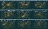
The cohesion options controls the overall formation of the landmass. High Cohesion (the default) will tend to produce a single large continent and some surrounding islands. Low Cohesion will result in snakey continents and islands and Medium will fall somewhere in between. Because the map is randomly generated using a heightmap there is never a guarantee of the exact continent/island mix, size or shape. You can see several examples in the screenshot attached at the end of this post, it shows a 3x3 grid of maps where each row is the cohesion (high, medium and low) and the columns are sea level (low, medium and high).

Mountians:
You have three options for mountains (and hills) to control their placement. This option is pretty self-explanatory and should deliver exactly what you expect from each setting. The default mountain setting will ensure that you have mountain ranges and plenty of hills.

Desert/Tundra/Jungle Chance:
These three options each have 6 possible settings. They can be turned off, preventing them from appearing on the map at all, or they can be adjusted to fit your taste. It is important to keep all three settings in mind when adjusting them as unusual combinations such as setting all three at 'High' may not always work as desired. Although they are independant setting the Desert Chance to high will reduce the total amount of grassland on the map which can indirectly reduce the amount of terrain available for jungles. Likewise, setting the Tundra Chance to high can indirectly reduce deserts as I do not allow desert terrain to be placed in cold areas regardless of the rainfall.

Plains Chance:
This option will allow you to increase the number of plains tiles in proportion to the grassland on the map. You can not decrease plains independantly of reducing the desert chance. Combining increased plains and increased deserts will significantly reduce the amount of grassland on the map.

With 2.60 there is a new option here for 'Great Plains' that will convert desert plots to plains based on temperature. This can include areas on the map that are cooler due to altitude, not just in the north, however the effect is most prominent in the north. Since it is temperature based, maps with little or no tundra may see a reduced effect using this setting and it will be less prominent on maps with y-wrap enabled.

Forest Density:
You can adjust the overall forest density with this option. This will change the amount of forests placed outside of areas with extremely high rainfall. In those areas you will still have dense forest/jungle regradless of this option. The forest density setting is most noticeable in plains tiles.

World Wrap:
The default setting is for a flat world (no wrap), here you can exable x, y or both x and y wrap. The map will be generated as if the world were flat regardless fo the wrap setting so there will be no land at the edges of the map. Having y wrap enabled changes the climate model to allow tundra and snow in the south as well as the north which can reduce the over amount of desert, jungle and grassland tiles available. The polar ice formation is also changed when y wrap is enabled so less ice is created towards the corners of the minimap making it possible to actually travel between the north and south map edges.

Starting Plot Rules: (New with 2.57)
This options controls how the flavorful starting locations are selected and whether or not you want all human player units to start on the same tile. There are three choices, each available twice, once for the default spread out unit starts and once for all units on the same tile.

Full flavor starts will follow the preferences defined for each civ whenever possible. Limited flavor starts uses modified preferences for civs that normally start in the tundra and snow so they will try to start at the edge of the tundra rather than burried in it. Minimal flavor rules will try to keep players from starting in tundra and it will add a process to clean up terrain around player starts replacing marsh, tundra and snow terrain with grassland (softly so it doesn't look like a big green BFC in the middle of tundra).

Rivers and Lakes:
The frequency and size of the rivers and lakes can be controlled with this setting. The default setting will produce numerous rivers, some of them spanning most of the continent.

Advanced Terrain:
This option (default is on or enabled), allows the map script to run an additional detail pass when generating the plate tectonics which will add extra details to the coastlines. Advanced Terrain also allows the script to place Haunted Lands, Ancient Forests, Kelp and Reefs if supported by the mod.

Supported custom Infotype list for mod authors:
Spoiler :

These are not required in order for the map to function, if they are missing from your mod the script will replace them with something else or skip them entirely. For example, if your mod does not have the haunted lands features you will instead see some burnt forests placed near the ancient ruins.

FEATURE_KELP
FEATURE_REEFS
FEATURE_HAUNTED_LANDS
FEATURE_CRYSTAL_PLAINS (Will not be placed if CIVILIZATION_FROZEN exists in mod)
IMPROVEMENT_CITY_RUINS_ANCIENT
TERRAIN_OCEAN_DEEP


Smart Climate:
This option has four possible choices. If left off (default) the map will use the standard climate model with no changes to the Desert, Tundra, Jungle and Plains selection you made. If turned on, it can adjust the climate based on the civs in the current game. Think of this as a way of reverse engineering natural selection, since civs will likely adapt to their surroundings this option makes those surroundings appropriate for the civs you have in your game. Instead of saying, "this world has no desert so we won't have a desert based civilization" we say, "this world has no desert based civilization so we don't need deserts." When using any of the three 'On' settings the map will also evaluate the continents and compensate for the potentially excessive deserts, tundra and snow that is possible. If you have a single massive continent the default climate model will naturally create more deserts than you would see with several smaller continents so the smart climate code will decrease the desert and plains amounts slightly for massive continents as well as adjusting for continents that are predominantly in the northern half of the map by reducing the maximum temperture allowed for tundra and snow.

For a more detailed description of the three Smart Climate settings, see below:
Spoiler :

On (Minimal Effects):
This is the most basic smart climate option. All this does is make sure that you have not disabled deserts, tundra or jungles when you have a civ in the game that favors them. It will not adjust the amount of deserts, tundra or jungles beyond that. For example, if you turn deserts, tundra and jungles off and then the Malakim are in your game this will turn the deserts back on. If you don't turn any of the terrains off you can use this setting to take advantage of the automatic compensation for massive continents without any other adjustments to your settings. In other words, if you're picky about what YOU choose but still want to make sure your map isn't messed up because you ended up with a single large continent in the north side of the map use this option.

On (Override Selection):
This setting will completely ignore your map option choices for desert, tundra and jungle chance and set them up automatically based on the civs in the game. This means if you have no Malakim in your FfH game, you will have no deserts. Likewise, if you're playing RifE and have the Malakim, D'Tesh and Scions in you game you will have a good amount of desert as well. The values here are determined by the total number of players so you will see much less of an effect when you have just the Malakim in a 12 civ game than you would with just the Malakim in a 4 civ game.

On (Modify Selection):
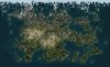
This last setting for the smart climate is probably the easiest to work with. It takes the options you selected for your desert, tundra and jungle chances and adjusts them based on the civs in the game. This means you can select a low chance for tundra and it will automatically increase the tundra chance if you end up with both the Doviello and Illians in your game. This setting works very will leaving the desert, tundra and jungle chances at their default values becauase, unlike the previous setting (Override Selection) this will not forcibly prevent those terrains from being in the game if there is no civ that uses them. So if you have no Malakim you will still have some desert but it will be very small. See the screenshot fo the map at the beginning of this post for an example of using this setting on a world that ended up with no desert civ in the game.

IMPORTANT NOTES:
If you're playing on standard, large or huge worlds I strongly suggest increasing the number of civs in your game if you use the last two Smart Climate options. By it's nature, the smart climate will give you the absolute most possible useable tiles for the civs in your game so using the default number of civs can result in a lot of room to grow
.

If you are using the Limited Flavor or Minimal Flavor starting plot rules the tundra will be very low or missing entirely using either modify or override smart climate options. I strongly recommend manually selecting your climate preferences and then using the smart climate's 'Minimal Effects' option for games with limited or minimal flavor.

Ancient City Ruins:
This option will place city ruins and roads on the map before the game. The ruins are clusters of ruins so they look visually different than that single ruins that litter the map over the course of the game (in my games anyway). If it upsets you that you can have city ruins closer than the minimum 2 tile seperation for normal cities do not turn this on. The roads that are placed around the ruins and between the cities are not always complete as a number of them are randomly removed. Each city cluster also has a chance to have an addition raw mana node as well as a graveyards. If you are playing a mod that supports haunted lands those will also be placed around the ruins. The ruins will be placed between 5 and 8 tiles away from player starts and only on the largest continent.

Compatability:
ErebusContinent has native support for base Fall From Heaven 2, Rise From Erebus (RiFE), Wild Mana, Orbis and Flavour Mod (with some minor issues). It will not work properly for mods based on anything other than Fall From Heaven, for those mods I recommend Cephalo's Perfect World 2.

ErebusContinent currently supports flavor starts for the following Civilizations in addition to all of the base Fall From Heaven civilizations:

AUSTERIN
ARCHOS
DURAL
CHISLEV
CUALLI
MAZATL
JOTNAR
D'TESH
MECHANOS
SCIONS
FAERIES
TLACATL
PALATINATE

Flavour Mod (and flavor start options in RifE and Wild Mana):
If you are using Flavour Mod or a mod that has incorporated Flavour Mod there are some minor issues to be aware of.
  • If you opt to have no jungles in your map, Flavour Mod will place marshes randomly across your world.
  • Flavour Mod will shuffle the players AFTER I place them so the flavor starts may not always be correct since we use different methods.
  • Flavour Mod disables calls to some normilization functions in the map script, so oddities with forest and jungle clearing with Flavour Mod enabled may occur.
The good news is that in most cases ErebusContinent and Flavor Mod compliment each other very well. If you experience odd behaviors please try running the map with Flavour Mod disabled to ensure that it is a problem with ErebusContinent and not an issue created by Flavour Mod. Despite these minor issure, Flavour Mod is still recommended as I do not use any special code for placing unique features, forts or other features used by FfH.

KNOWN ISSUES:
  • I do not know if it is caused by Wild Mana or the integrated Flavour Mod however games in Wild Mana with Flavor Starts enabled can have riverside tiles in the desert that are missing floodplains. Missing floodplains will NOT occur with flavor starts disabled or in base FfH and I did not see that issue in my RiFE testing.
  • Orbis spawns critters from city ruins, use the Ancient Ruins map option at your own risk :)

Recommended Settings:
A lot of people have asked how I use this script, being the author my personal tastes obviously impact the script so here is what I do:

Size: Large (with 10-12 civs)
Sea Level: Low
Cohesion: Medium
(Or, high cohesion and medium sea level for fewer islands)

Mountains, Deserts, Tundra, Jungles, Forest Density, Rivers and Lakes are normally left at their default setting. Sometimes I want a specific world and manually adjust some like turning jungles or tundra off, not often though.

Plains: Great Plains
Advanced Terrain: On
Smart Climate: On (modify selection)
Ancient Ruins: On

With 2.50 the build time for a map with these settings on my PC is around 40-45 seconds. Prior to 2.50 with similar settings it would take anywhere form 1:20 to almost 2 minutes.

If you notice that the AI moves it's starting settlers into a poor position frequently (too close to a neighbor for example) you can fix this by using the Advanced Start game option. Hopefully this is less of an issue with 2.70.

Enjoy!
 

Attachments

  • erebus2_50_grid.jpg
    erebus2_50_grid.jpg
    424.4 KB · Views: 4,978
  • erebus255map.jpg
    erebus255map.jpg
    71.4 KB · Views: 24,734
  • ErebusContinent2_71.zip
    51.4 KB · Views: 5,122
those screenshots look great, well done! :goodjob:

I'm gonna try giving some feedback as soon as I try the mapscript... btw, if you can include cylindrical and toroidal world wraps, then by all means go for it :D
 
Cool! This looks very interesting! :)

Just wondering... if I usually use map sizes with a grid size of 40x24, what would be a sensible entry into the override grid sizes used in your map script?

Thanks

Al :)
 
This looks like an improvement on the original.:goodjob:
Thank, but I didn't do much to the orignal method of generating the map aside from changing the dimensions since Colonization uses tall skinny maps.

[to_xp]Gekko;7718330 said:
those screenshots look great, well done! :goodjob:

I'm gonna try giving some feedback as soon as I try the mapscript... btw, if you can include cylindrical and toroidal world wraps, then by all means go for it :D
Thanks, feedback is always appreciated! It's been working very well for me but there are some things that may or may not be appropriate for everybody such as the map size (uses Terra sizes). I'll add wrap options today as that should only take a minute, I'm also going to add options to control the mountains (more or less as desired) and climates. Rather than a single climate option I'm going to add the ability to control tundra, desert and jungle zones independantly so you can have a map with no tundra, no desert and/or no jungle if you really want to. Should be fun :)

Cool! This looks very interesting! :)

Just wondering... if I usually use map sizes with a grid size of 40x24, what would be a sensible entry into the override grid sizes used in your map script?

Thanks

Al :)
Huge is 38x24, you can find the grid sizes near the end of the file and you should be able to just change the 38 to a 40 without any problems. The finished map might appear slightly stretched if you adjust the number too far out of their current aspect ratio because the script generates a seperate map first and then resizes it.
 
Huge is 38x24, you can find the grid sizes near the end of the file and you should be able to just change the 38 to a 40 without any problems. The finished map might appear slightly stretched if you adjust the number too far out of their current aspect ratio because the script generates a seperate map first and then resizes it.

So it actually stretches the tiles? The graphics?

Al
 
Btw 45x28 should be the right size for your map right?

Al
 
No, it won't stretch the tiles, it will stretch the heightmap which can result in landmasses that look elongated or compacted when looking at the world map. In game the tiles themselves will be fine.

40x24 would probably work fine as would 45x28 but something like 40x20 would look a bit wierd.
 
I uploaded a new version (1.1) with more options you can set in game. I ran into some issues with adding x & y wrap (doesn't like may changes to Cephalos original climate code apparently) so that'll be a bit.
 
OK testing now.

It doesn't seem to like my custom map size (think it somehow filled the whole map with grasslands LOL). Therefore I'm testing it on huge. Looks nice so far! :)

Al
 
sweet, I love the maps I've generated with version 1.1. so far! :goodjob:

feedback:

1) as you noticed, sometimes a mountain range will completely enclose one or more tiles... that should be fixed as it might lead to whacky things happening. possibly set the enclosed tile(s) to be a peak also?

2) it would be great to add that code from Erebus that automatically clears forests and jungles from the starting positions, possibly as a toggleable option. I think it makes the AI early game a lot more effective, and we all know how that is critical to everything that comes AFTER :D

3) mountain ranges are nice, but sometimes they look weird ( 1 tile wide, 10 tiles long mountain ranges for example :D )

4) Less Islands landform tends to generate 1 or 2 continents with a couple smaller islands, and More Islands results in, well, more (small) islands. I'd love to have another option in the "Landform" dropdown that generates some continents ( like a random number between 3 and 6 for example ) without creating many small islands :)

5) starting positions could use some tweaking so that no civ gets placed in the middle of ice or desert or jungle.

despite these issues, the map is already very enjoyable. can't wait for world wraps :D

thanx for this and keep up the good work :goodjob:
 
OK testing now.

It doesn't seem to like my custom map size (think it somehow filled the whole map with grasslands LOL). Therefore I'm testing it on huge. Looks nice so far! :)

Al
It can get pretty picky. If you enable python exceptions in your Civ4 ini file it'll warn you if the map size isn't compatible.

[to_xp]Gekko;7719156 said:
sweet, I love the maps I've generated with version 1.1. so far! :goodjob:

feedback:

1) as you noticed, sometimes a mountain range will completely enclose one or more tiles... that should be fixed as it might lead to whacky things happening. possibly set the enclosed tile(s) to be a peak also?

2) it would be great to add that code from Erebus that automatically clears forests and jungles from the starting positions, possibly as a toggleable option. I think it makes the AI early game a lot more effective, and we all know how that is critical to everything that comes AFTER :D

3) mountain ranges are nice, but sometimes they look weird ( 1 tile wide, 10 tiles long mountain ranges for example :D )

4) Less Islands landform tends to generate 1 or 2 continents with a couple smaller islands, and More Islands results in, well, more (small) islands. I'd love to have another option in the "Landform" dropdown that generates some continents ( like a random number between 3 and 6 for example ) without creating many small islands :)

5) starting positions could use some tweaking so that no civ gets placed in the middle of ice or desert or jungle.

despite these issues, the map is already very enjoyable. can't wait for world wraps :D

thanx for this and keep up the good work :goodjob:
Ok, by the numbers :)

1) Yeah, I have two checks in there but they aren't working very well (obviously) :). When you see a single enclosed tile it's normally because there were two or three but they didn't all get zapped. I may switch it entirely so that rather than build them into peaks I reduce one of the surrounding peaks into hills to create a passage. With 1.1 it almost never happens unless you run it with more mountains.

2) Right now I don't have anything in there for starting plots other than bypassing some of the default normalization routines as they break the rivers. Without 'flavor' starts any change to surrounding features will have to affect everybody or nobody though, so even the elves will start with clear tiles around them, might not be entirely bad that way though as it'll add some delay before their insane bonuses kick in. I'll be sure to get some of the normilization code in soon.

3) Yeah, god bless the random number generator :) I'm working on the plate generation and detail code to break them up and add more interesting patterns. I doublt they'll ever be perfect 100% of the time but I should be able to get them to where it's better most of the time.

4) The world is created by generating a random heightmap and then modifying that with randomly staggered tectonic plates of random sizes and shapes. It's kind of like taking a piece of paper and crumpling it up and the laying it out flat again before filling in the lowest spots with water. Because of that it's difficult to control the exact landmass shapes and placements so that will probably never get 'fixed.' What I have been working on is a change to the 'Landform' option, it'll become a 'Cohesion' option instead with more than two choices. It will still generate the land in the same way though so random small islands will exist but the whole world may be a long, snakey pangaea at the same time. Best I can hope for is to make undesirable results less likely.

5) Yeah, it uses the default Civ4 method which generally sucks. Personally, I use the flavor starts (from Flavor Mod and/or Fall Further) with a few extra civs in the game, they are almost all workable starts then. Unlike the Erebus/Creation map script flavor starts won't be crippling to some civs as there is almost always something useable near by. I went through a bit of extra effort to make sure it is virtually impossible to place a city somewhere that is either all hills or all flat lands and rivers are fairly abundant.

Wrapping should be in within a day or two. I'll have support for flat, x only, y only and x and y wrapping. I'll need to add some adjustments to the climate to avoid hard lines between climate types at the map edges.

I have to go do responsible stuff today, the downside of being a parent, so I probably won't do anymore updates unless I get back this afternoon and feel inspired enough to finish up my changes to cohesion. If I do that I'll post it so you can see if you like the way it breaks up land better.

Oh, and you should try some cool combinations with the climates, I was testing reduced tundra, increased desert and no jungle and the results were pretty cool looking. I also like being able to remove tundra & snow entirely if I feel like picking my opponents and leave out the Illians and Doviello, it makes more of the map usable for the other civs.
 
2)Without 'flavor' starts any change to surrounding features will have to affect everybody or nobody though, so even the elves will start with clear tiles around them, might not be entirely bad that way though as it'll add some delay before their insane bonuses kick in. I'll be sure to get some of the normilization code in soon.

I'm pretty sure that in Erebus that "starting ring chop" does NOT happen for Elven civs. I tried it out and indeed their starting positions had forests in the 3*3 ring. of course, Erebus does include its own "flavor start" system IIRC, so that might be not be as easy to do in this mapscript. as you said though, this might actually make the elves more balanced :D
 
[to_xp]Gekko;7719311 said:
I'm pretty sure that in Erebus that "starting ring chop" does NOT happen for Elven civs. I tried it out and indeed their starting positions had forests in the 3*3 ring. of course, Erebus does include its own "flavor start" system IIRC, so that might be not be as easy to do in this mapscript. as you said though, this might actually make the elves more balanced :D
Yeah, in Erebus.py that's part of the flavor starts. He also handles the placement of most of the unique features also which works very well.

I've uploaded a new version. Wrapping is in and working, I'm not a fan of wrapping on this style of map so I can't say much for the quality, but it is in and functioning along with some sanity checks to make sure nothing absurd happens. When Y-wrap is enabled (alone or combined with X-wrap) the latitude range is changed so you will have tundra on both the top and bottom, this prevents any wierd effects when you cross the seam and wrap to the other side. I did force some separation on maps with wrap enabled so you shouldn't be able to circumnavigate the globe without getting your feet wet.

It also looks like the isolated plots enclosed by peaks are gone. The new method breaks up the large mountain ranges a bit as well so if you really like to have lots of peaks you'll need to use the option for more mountains.

And, I've re-enabled the food bonus normalization so any really crappy starts should get some added resources. I also added a quick pass to remove any forests or jungles in the starting plot and all of the adjacent plots (3x3 box).

Have fun with it :)
 
great job on 1.2 , this is indeed the mapscript I'm going to play from now on :goodjob:

only complaints with this version would be about the icy areas ( both wraps activated ) :
too much ice on default ( reduced tundra feels like what default should be imho ) , and icy regions being 100% ice look very bad when compared to how great the rest of the map looks. some mixed tundra/ice would be a lot better. possibly simulate colder temperature at higher altitudes, making a hill tile more likely to be ice, and a flat tile more likely to be tundra? that would also make the terrain a bit less crappy since both ice and tundra hills give one hammer, but flat snow terrain is just plain useless.

also, civs can still spawn in the middle of ice sometimes, although the food bonus normalization does help a bit with that...

desert OTOH is very very very uncommon, even with increased amount. which makes Malakim sad :D what gives?

a couple more things I noticed:

1) forests and jungles getting autocut around starting locations is great. too bad that it doesn't work when flavourmod is activated :\

2) is there a way to make sure that all starting units are placed on the same continent? it's kinda frustrating to start with a settler on a continent and a warrior on another one, separated by a couple tiles of water :D

3) it would be nice to set all lakes to be max 10 tiles, cuz if they exceed that they are considered coast ( salt water ) by the game engine.

4) another nice tweak would be making sure that lairs don't get placed on tiny 1-tile islands or similar. it's weird to find a micro island with crazy amounts of lizardmen on it :D

5) last but definitely not least, a dropdown option for "sea level" would be awesome. you know, being able to roughly choose the percentage of water on the map. :)
 
[to_xp]Gekko;7721162 said:
great job on 1.2 , this is indeed the mapscript I'm going to play from now on :goodjob:

...
I'm glad it's working for you, let's see how close to perfect I can get it :)

I'll see what I can do with the y-wrap ice problem, it's the result of putting so much land where there normally isn't any land so I should just be able to reduce the max lattitude ot 85 or 80 to fix it. If not I'm sure I can boost the pole temps when y wrapping is enabled.

Deserts will be tricky, you need a large landmass to get a decent sized desert so with anything other than high cohesion you won't see much at all.

1) Yeah, I noticed that myself, not much I can do about that unfortunately.

2) The only thing I get to define in the map script is the starting plot, the game itself decides where to drop your units. Theres a setting somewhere to force all of your units to start on the same tile like it does for the AI but I can't remember where that is.

3) I'll look into giving you some more control over the lakes. They're actually created as part of the river system and the really large seas are the result of multiple lakes growing into each other. I do have a bit of control over the rate at which they grow so I'll see if I can get that into another map option for you.

4) That's actually a really easy XML fix outside of the map script. I would like to eventually add in my own code for placing the resources, lairs and unique features but I have no idea if or when I will get around to that.

5) I can do that, currently the sea level rises as you lower cohesion but I can add in some fine tuning on that.
 
thanx for the quick reply :)

regarding deserts, I am indeed using high cohesion. I guess that what causes them to be so rare is the fact that I'm trying this on tiny and small maps and it doesn't scale very well..
 
Theres a setting somewhere to force all of your units to start on the same tile like it does for the AI but I can't remember where that is.

You are probably looking for this method from CvMapScriptInterface.py:

Code:
def startHumansOnSameTile():
	"Returns true if all human units should start on the same tile"
	return False

---------------------

A question: Would you mind, if I add your map script to the additional map scripts collection coming with FlavourMod? I was waiting for someone doing the conversion of Cephalo's "Faire Weather" map script for quite some time. Good job.
 
@Jean Elcard: do you know why the "autocut forest/jungle around starting locations" doesn't work with flavourmod enabled? is there a workaround?
 
Top Bottom