- Home
- Forums
- CIVILIZATION IV
- Civ4 - Creation & Customization
- Civ4 - Project & Mod Development
- Civ4 - Rhye's and Fall of Civilization
- Rhye's and Fall - Dawn of Civilization
You are using an out of date browser. It may not display this or other websites correctly.
You should upgrade or use an alternative browser.
You should upgrade or use an alternative browser.
Alternative Map during 1.18
- Thread starter Leoreth
- Start date
Right now, I finished setting up regions. This is something I already had put some work into earlier on, so it was mostly cleaning up and expanding upon what was already there. The main differences are:
- Number of regions nearly doubled to 82, allowing more specificity in using regions to define e.g. religion spread areas.
- The region of each tile is now displayed by default in the tooltip.
- Added "water regions" to describe seas and lakes. This has no mechanical impact but allows displaying their name in the tooltip. There are 83 water regions now, most of them lakes.
- A region is now defined for every tile on the map, including peaks.
- Regions are defined in a CSV file for easier editing and to avoid wasting memory in Python.
Oh I see, I assumed I had access to the private repo but apparently not. Would you mind adding me to it? (https://github.com/etiennefd)
Thanks! I was just looking at the changes for fun and saw a tiny opportunity for improvement. I see you've changed the spread of Judaism in the late game from
I think you should also add
[rCanada, rAlaska, rUnitedStates] to [rOntario, rMaritimes, rAtlanticSeaboard, rMidwest]. This is definitely missing rQuebec—Montreal was historically the main Jewish center in Canada, and though that's less true today, there are still many Jews here. Quebec City also used to have a small community. I think you should also add
rCalifornia and rCascadia, since the West Coast in both Canada and the US has a sizeable Jewish population. The Canadian Maritimes, on the other hand, don't really have one, though it's fine to leave them in the list as a possibility.Thanks. This is definitely just a first pass that needs to be revisited, and in general I would like to find a solution that syncs the religion spread definitions in RegionMap.py with the scripted spread in Religions.py. With each of these points there is a whole rabbit hole to go down with and I'd rather not end up in wonderland ")
I just finished entirely reimplementing settler and war maps and then defining the new maps themselves. Like other maps, they are now defined as CSV files outside of the Python code. The general principles behind them are the same but I changed the range of numbers and some aspects of what they mean.
Settler values still also control stability. They range generally between 0-20. 1+ means historical area. The AI will not settle any tile with values below 2. The higher the settler value, the more the AI prioritises the tile.
War values range between 0-5. Values greater than 0 means that AIs will be more likely to declare wars on civilizations controlling these tiles, and will prioritise conquering cities with high war values.
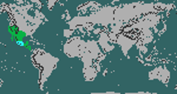
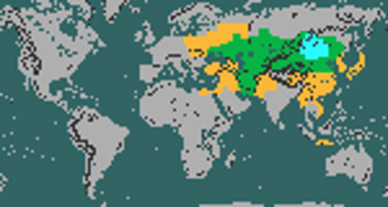
This also means that the colour coded tile stability categories on the map have changed:
You can look at all the current settler maps and war maps on google sheets.
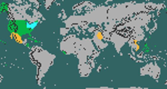
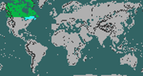
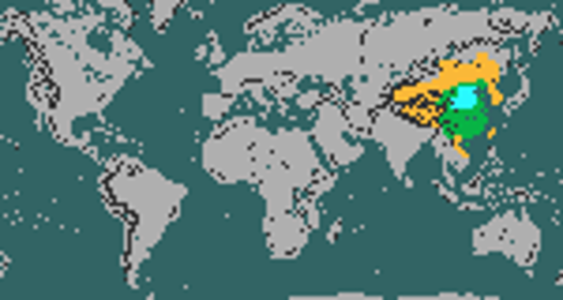
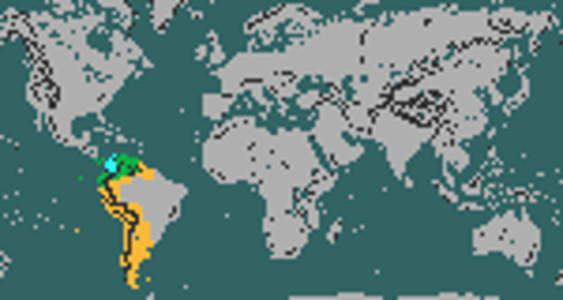
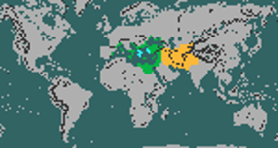
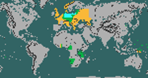
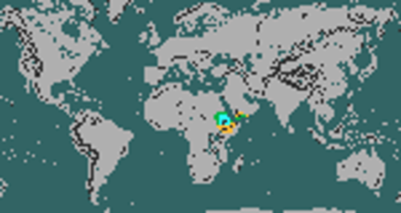
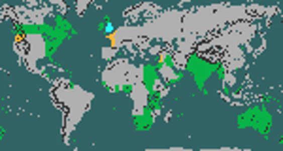
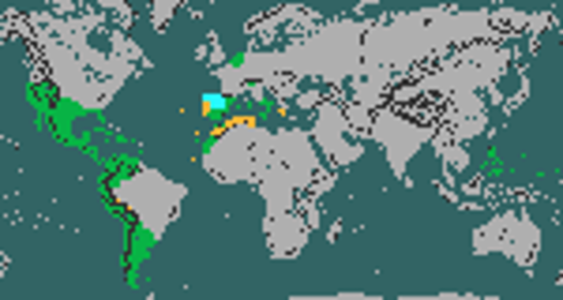
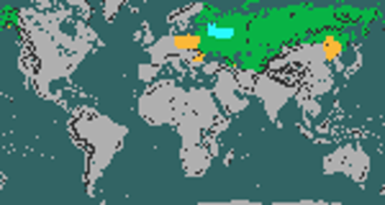
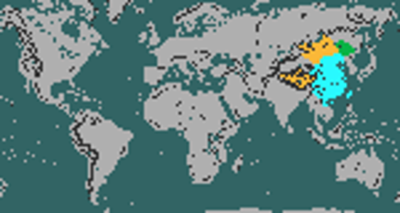
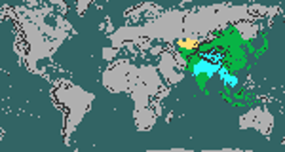
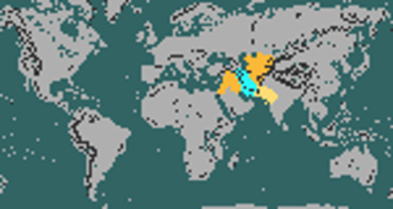
I also fully recreated the colour coded png stability maps which will attach here as reference (foreign in grey for better contrast). This is just the first iteration of these maps to make the game functional, and there is definitely room for improvement in the details. I have already noticed some things that I want to correct, and plan to give them more attention later on.
Settler values still also control stability. They range generally between 0-20. 1+ means historical area. The AI will not settle any tile with values below 2. The higher the settler value, the more the AI prioritises the tile.
War values range between 0-5. Values greater than 0 means that AIs will be more likely to declare wars on civilizations controlling these tiles, and will prioritise conquering cities with high war values.
This also means that the colour coded tile stability categories on the map have changed:
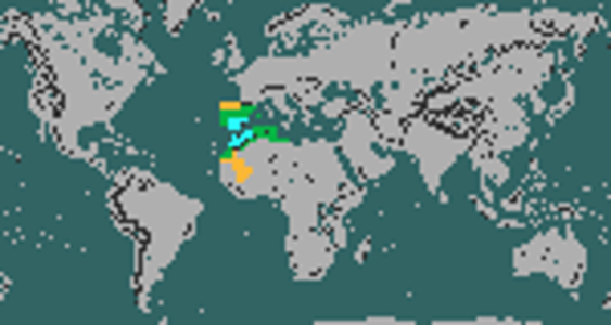
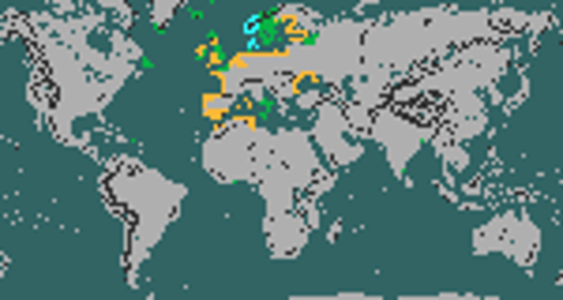
- Core Area (cyan): cities in this area contribute to how much population you can control before becoming unstable
- Historical Area (green): settler value > 0, cities in this area make you less stable but at a significantly reduced rate, founding and conquering cities here grants a temporary stability boost
- Conquest Area (yellow): settler value = 0 and war value > 1, cities in this area fully contribute to making you less stable, conquering cities here grants a temporary stability boost
- Foreign Area (red): settler value = 0 and war value < 2, cities in this area fully contribute to making you less stable
You can look at all the current settler maps and war maps on google sheets.
I also fully recreated the colour coded png stability maps which will attach here as reference (foreign in grey for better contrast). This is just the first iteration of these maps to make the game functional, and there is definitely room for improvement in the details. I have already noticed some things that I want to correct, and plan to give them more attention later on.
Attachments
-
 America.png130.8 KB · Views: 982
 -
 Arabia.png129.9 KB · Views: 921
 -
 Argentina.png125 KB · Views: 767
 -
 Aztecs.png124.6 KB · Views: 730
 -
 Babylonia.png126.3 KB · Views: 706
 -
 Brazil.png126.4 KB · Views: 717
 -
 Byzantium.png128 KB · Views: 758
 -
 Canada.png125.8 KB · Views: 851
 -
 China.png129.1 KB · Views: 855
 -
 Colombia.png127.1 KB · Views: 837
Last edited:
Congo -> Inca
Attachments
-
 Inca.png123.7 KB · Views: 779
 -
 Holy_Rome.png128.3 KB · Views: 729
 -
 Harappa.png125.2 KB · Views: 735
 -
 Greece.png129.9 KB · Views: 772
 -
 Germany.png133.2 KB · Views: 822
 -
 France.png138.3 KB · Views: 808
 -
 Ethiopia.png124.8 KB · Views: 826
 -
 England.png136.3 KB · Views: 791
 -
 Egypt.png125.9 KB · Views: 771
 -
 Congo.png125.2 KB · Views: 647
India -> Mexico
Attachments
-
 India.png126.4 KB · Views: 651
 -
 Indonesia.png124.8 KB · Views: 682
 -
 Italy.png127.5 KB · Views: 671
 -
 Iran.png126.8 KB · Views: 730
 -
 Japan.png132.7 KB · Views: 736
 -
 Khmer.png124.7 KB · Views: 729
 -
 Korea.png124.3 KB · Views: 656
 -
 Mali.png125.1 KB · Views: 648
 -
 Maya.png123.8 KB · Views: 646
 -
 Mexico.png125.4 KB · Views: 725
Mongolia -> Rome
Attachments
-
 Mongolia.png136.9 KB · Views: 761
 -
 Rome.png130.4 KB · Views: 759
 -
 Portugal.png132.7 KB · Views: 702
 -
 Polynesia.png124.2 KB · Views: 668
 -
 Poland.png126.9 KB · Views: 627
 -
 Phoenicia.png126.4 KB · Views: 617
 -
 Persia.png129.2 KB · Views: 626
 -
 Netherlands.png131.3 KB · Views: 615
 -
 Mughals.png126.3 KB · Views: 608
 -
 Moors.png126.3 KB · Views: 630
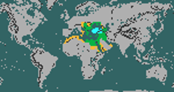
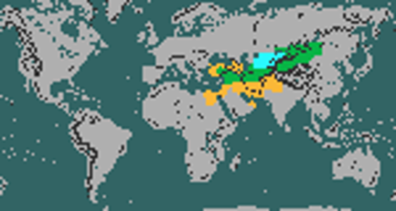
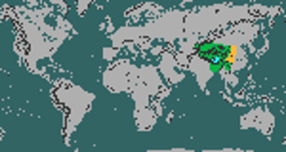
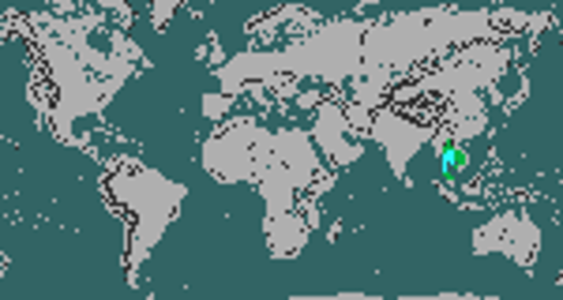

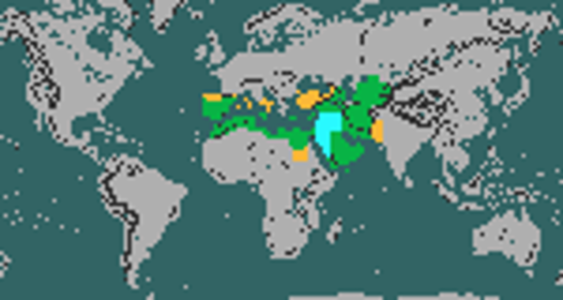
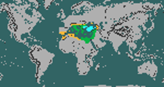
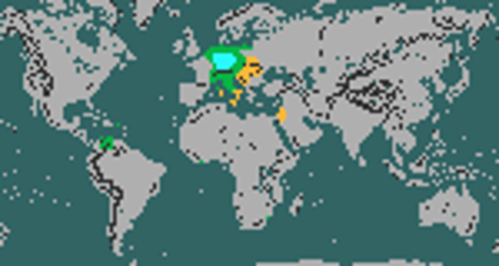
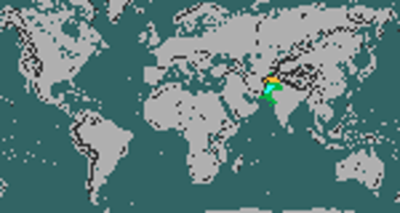
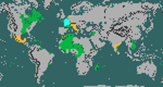
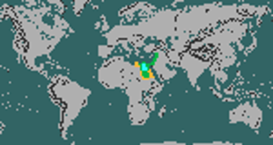
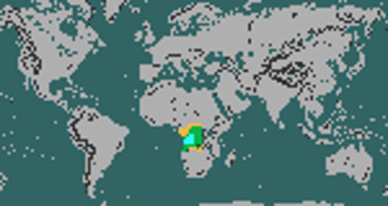
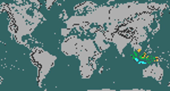
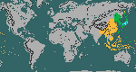
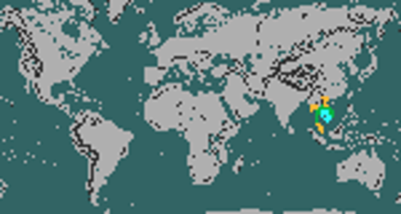
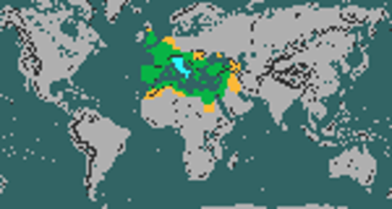
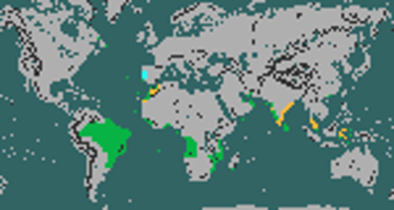
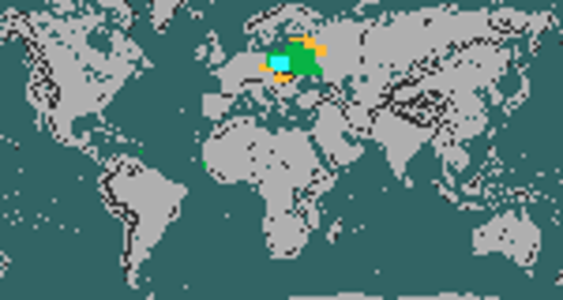
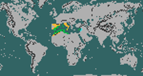
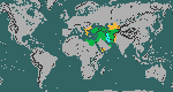
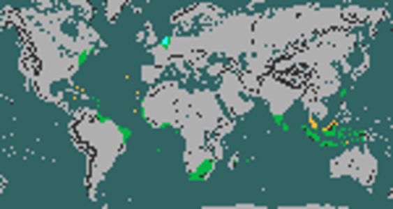
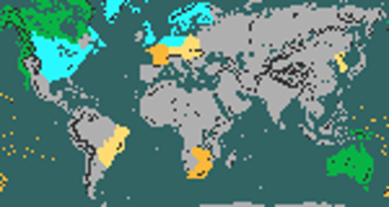
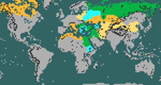
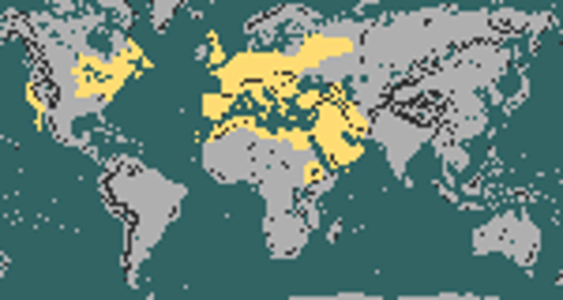
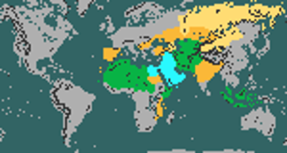
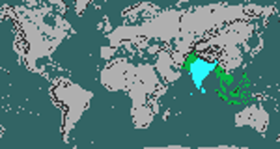
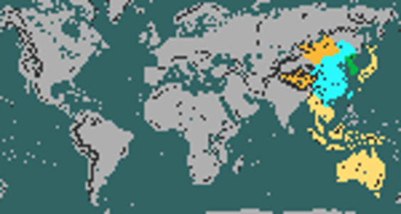
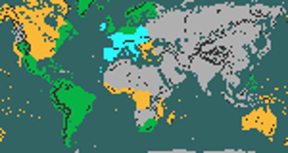
Also, for fun but also later design iterations I did the same for religion spread areas.
Cyan = core, green = historical, dark yellow = periphery, light yellow = minority
Note that in practice, for Orthodoxy and Catholicism they are using the composite of all Christian maps until the respective denomination is founded.
Cyan = core, green = historical, dark yellow = periphery, light yellow = minority
Note that in practice, for Orthodoxy and Catholicism they are using the composite of all Christian maps until the respective denomination is founded.
Attachments
-
 Taoism.png128.7 KB · Views: 868
 -
 Protestantism.png138.3 KB · Views: 768
 -
 Orthodoxy.png143 KB · Views: 753
 -
 Judaism.png137.2 KB · Views: 720
 -
 Islam.png142.9 KB · Views: 700
 -
 Hinduism.png126.8 KB · Views: 688
 -
 Confucianism.png133.7 KB · Views: 702
 -
 Catholicism.png140.7 KB · Views: 700
 -
 Buddhism.png131.6 KB · Views: 705
 -
 Zoroastrianism.png128 KB · Views: 934
Very nice, hype is slowly building up and these maps look pretty good from a quick glance! I must say though that I was excited to see stability and war maps for some of the new civs such as Kievan Rus and Sweden (especially to compare Swedish colonial territories with those of the Viking civ) but I realized that's probably going to happen later on as I guess they're not implemented yet.
Dracosolon
King
Great job! Are those region-based?
FishFishFish
Warlord
- Joined
- Jun 26, 2021
- Messages
- 176
Perhaps a green dot around where Equatorial Guinea is could be included in Spain's map to represent Spanish Guinea?
Last edited:
uminacas
Chieftain
- Joined
- Feb 15, 2023
- Messages
- 10
What represents those dots in West Africa and the Caribbean in Poland's map?Mongolia -> Rome
Only the religion maps are region based, all stability/settler/war maps are tile based.Great job! Are those region-based?
Like I said above, the religion spread maps are region based, so they do not allow this degree of granularity. Maybe a minority status in Dravidia is justified.Can I suggest adding a few green (historical) or dark yellow (peripheral) tiles to the Orthodoxy map around the southwestern tip of India? This would represent the 'Saint Thomas Christians' of Kerala.
There were abortive Couronian colonies there, I decided to incorporate them into Poland's maps for some variety.What represents those dots in West Africa and the Caribbean in Poland's map?
Similar threads
- Replies
- 39
- Views
- 8K
- Replies
- 71
- Views
- 12K
- Replies
- 51
- Views
- 11K
- Replies
- 200
- Views
- 26K