El_hidalgo's World Maps

Argonath: I added the extra space at the top of the America map and the took a screen shot of what it would look like if I joined the two halves as they are now. As you can see, we need to add some ocean in between the halves. You will need room to complete the landmasses for Newfoundland and for western North Africa. How much ocean do you think you want in between? Total, counting the space for the additional landmass. I can't add more ocean after I join the halves because it's too much of a pain then. Also it has to be in multiples of 10 or the grep work becomes too much of a pain.

I'm no too sure. I'm looking at a map right now, and the size of the Atlantic is about the distance from Ukraine to Spain I think. So, whatever the width of the Europe map is, use about to thirds of it- probably around 100 tiles or so. You're guess is about as good as mine on this one. If you do make it 100 tiles we're looking at a map of biblical proportions here, probably the one of the biggest ever on civ. So maybe just use enough to require astronomy to get to America, like 10 tiles between em? I'm not sure and I'll leave it to your judgement, but definitely make it take a couple turns for a galleon to get from Europe to North America for sure.
 
I'm no too sure. I'm looking at a map right now, and the size of the Atlantic is about the distance from Ukraine to Spain I think. So, whatever the width of the Europe map is, use about to thirds of it- probably around 100 tiles or so. You're guess is about as good as mine on this one. If you do make it 100 tiles we're looking at a map of biblical proportions here, probably the one of the biggest ever on civ. So maybe just use enough to require astronomy to get to America, like 10 tiles between em? I'm not sure and I'll leave it to your judgement, but definitely make it take a couple turns for a galleon to get from Europe to North America for sure.

Man, I don't know what happened. I finished up another map and then I went back to this one and all the work I had done on it is gone. The file reverted to a previous version somehow. I don't know how that happened. If you want I can send you the files and tell you how to do the work, but I don't have the heart to start over. I'm sorry to leave you in the lurch like this. Maybe I can pick it up again some other time.
 
Nice work on NZ :goodjob:

Anyway you can make a korean map? One that would be good for a korean war scenario? theres one out there but its the sea of japan i bleive, probably remove japan and rotate it(if poosible) so korea is fasing N/S realistically instead of E/W

Thanks! I actually just started a map of Japan... I might be able to do a Korean map while I'm in the neighborhood though. :D 
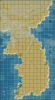
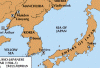
Would roughly 20x30 be too small? I think I could do something around that size without too much difficulty/time. If you the Sea of Japan map would work for you, then I'm pretty sure that would work too. I threw something together really quick so you can get an idea of the scale. It's very alpha stage at this point, of course, and no terrain details at all, so don't judge it just yet!
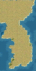
 

Attachments

  • Korea_small.png
    Korea_small.png
    33.3 KB · Views: 195
  • Korea20x30.png
    Korea20x30.png
    457.4 KB · Views: 201
definatly looks great, nice work

only thing i would say it add several rows on bottom to include the island of cheju-do since its pretty big

Well, here it is. I was going to do one from scratch, but I found another Sea of Japan type of map (but not at an angle like the other one) that I could cut down to just Korea, so I just decided to use that. It's very good and larger than what I was thinking of doing.
 
It would maybe be easier to convert the sea of japan one ( the one you used for korea), make sure it has most of Japan, and just extend it to include manchuria

Well, it depends on the area you need. That map is over 12,000 tiles total (when you include Japan and the little bit of Manchuria that I chopped), so it's already huge (by comparison, my entire E Asia map is 5100 tiles). Is roughly 46 degrees N latitude far enough north? How far west? Would 120 degrees E longitude work? Reading up on the war a little, it appears that the main battles took place in this area. It would probably add around 3000 tiles. That might be doable. Maybe. However, that would not give Russia many cities. Just Vladivostok, basically. Well, and Port Arthur.

By the way, this is where the map comes from, if you didn't know. I believe a clean copy of the map is included in the scenario. I'm not sure who made the map, if ZB did or someone else.
 
Top Bottom