[TOT] &ToTPP with Lua : EpicWWiiEurope

And just as an aside, the Fw190D9 which was specifically built to address issues the A-series had at altitude. As you can see, while it is better than the A series, it's still not close to the Ta152, which was arguably Germany's best prop fighter of the war. The Ta152 was an absolute beast at altitude. Good thing that only 69 were built!

 
Tried to come with something, considering two sets of values for planes :

The one noted in rules shall be used for bombardment, this being the active action of them.
Another one (Att,Def & Fir) shall be used with aerial fights and aa shots.

Some planes may benefit from upgrades to these coming with some techs.

That makes me realise I shall create a keypress to display units informations, releasing stats, abilities and their related keys to use, warnings, etc in a dialog box instead of relying on civilopedia.


Fortifications used as borders got erased from map, and I believe when needed got placed back (Maginot and Siegfried Line, Belgium's and Netherland's defense lines, italian, polish, greek and turkish ones ...)
Also placed the Neutral borders and the Molotov-Ribbentrop pact line (directly the evolved one from mid-sept39)

exemple3.png

Plus, I'm rather seriously thinking about putting the Turk with Neutral civs considering both its hard gameplay (units limitations and imports) be it played and its diplomatic restrictions with its key placement.

The earned civ should then be a polyvalent one to figure states left alones facing a power. Maybe some partisans too (to figure the civil war in occupied Yougoslavia per exemple) ?
 
Many thoughts are coming to life about this project currently paused while finishing the TES second version and enthousiasmed by The Spanish Civil War heavy update by Pablostuka coming soon :

+ Land War shall see an overhaul change, taking full advantage of its new ToTpp function, thus allowing for partial combats, retreats, strength and units personalisation.
+Naval War shall see a change too, with fleets, mine fields, and area of effect diverse reactions.
+Air War shall be roughly the same as planned.

+An introduction of "unit equipments" personilizing these, allowing to figure if an infantry (or armored) division has anti-tank equipments, more or less modern rifles, an artillery bataillon, anti-air canons, if a fleet has mine layers or mine sweepers, if bombers have low-middle-high altitude bomb tools or not, etc. Its is planned to have these upgrades linked with cities industries.

+Instead of getting ennemies' railroads out and his in (as first planned) each player turn, I'd rather have them spawned
-only in its territory
-only for few units : workers AND a train transporter unit going on railroads only. Railroad thus will become back an infinite movement factor, freeing movement abilities for planes !

+The "America Support" lone city is to be altered, scinded into tiny portions of canada and usa to interact with. Few ocean tiles shall picture the vastness of the Atlantic.

+Civilisations are to be altered, with the Italian and the Turc disapearing in favor to unplayable ones "Minor Axis" (at the beginning only consisting of slovakia) and "Minor Allied" (at the beginning consisting of Canadia and Poland). French shall remain first, its playability questionnable.

+Following influences from some of the best scenario avaibles, there shall be less diplomatic freedom than first intended, trying to follow more history and taking advantage for that of the added technologies thus proposing a lower tech paradigm to multiply tech interractions with the game.

+Pablostuka's idea of spying system shall be adapted there too. An important feature to bomber ennemies inlands !

+I'd like to alter the "natural healing" system provided by civ2, making it dependant of industries and manpower reserves.

Well, all this, maybe some more or less coming after the TES Stormcloak Rebellion v2.
 
Last edited:
+I'd like to alter the "natural healing" system provided by civ2, making it dependant of with industries and manpower reserves.

100% super interested to hear how you do this as I think that would simply be grand.
 
+I'd like to alter the "natural healing" system provided by civ2, making it dependant of with industries and manpower reserves.

100% super interested to hear how you do this as I think that would simply be grand.
These functions control the unit flag that is set when a unit moves (even along a railroad). When the flag is set, the unit doesn't get healed on the next turn. In OTR, clearing this flag was used so that damaged convoys had a chance of making it to England since they could move and still recover their health and movement points.

Code:
gen.isMoved(unit)-->boolean
gen.setMoved(unit)-->void
gen.clearMoved(unit)-->void

I'm not sure exactly when the healing takes place, but that shouldn't be too hard to test.
 
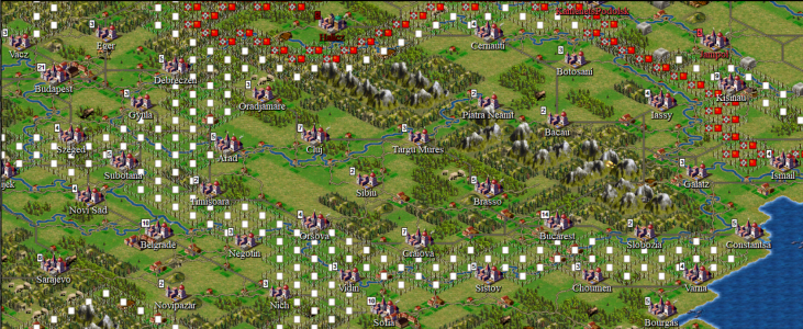
Took little time altering the map used thus far.

Romania saw little changes with its geography and earned two minor cities
Exemple6.png
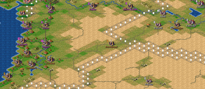
Palestine and Transjordan saw big changes too, also with alterations in Irak.
Exemple3.png
Then, there's a question on my mind at this point :

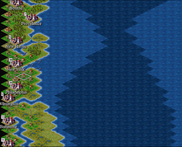
Shall USA and Canada be partly represented (like it somehow was in the original ww2 scenario from microprose) ?
Exemple4.png
Exemple5.png
Exemple.png
Which dictate the use of an ocean tile eating massively movepoints,
Or shall we just figure their influence with Lua only ?

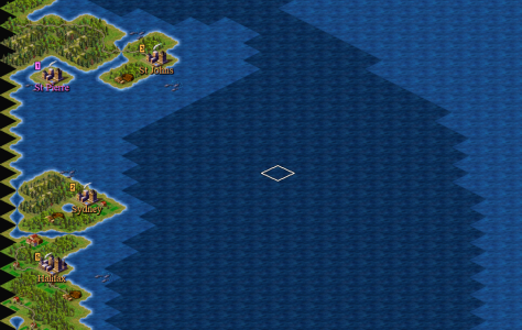
Exemple2.png
I began building the america border and then with weeks of thoughts came to regret it, and created a new file with it erased.
I thus have two saves avaible to go on depending on that choice.

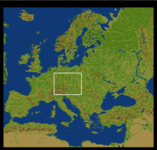
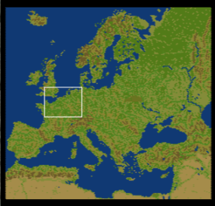
(please notice that these minimaps are indeed displaying the summer version of the map, with it supposed to evolve with seasons)

That will wait few more days though, main attention and time beeing given to the final stroke to the TES scenario.
@JPetroski , @Pablostuka , @Blake00 and any other passing by, what are your thoughts on that matter please ?
 
Last edited:
I don't really think you need it if America is only going to be played by the AI. Frankly I think regardless of which you do you'll still likely spend so much time using lua to get them working properly that you mighty as well keep the map pretty, but that's just my opinion and ultimately it is your call :)
 
What do the different shades of the sea mean? Does the intensity of the shades have some kind of functionality, or is it just for aesthetics?
 
What do the different shades of the sea mean? Does the intensity of the shades have some kind of functionality, or is it just for aesthetics?
The darker shade would be an ocean tile, a "bonus" tile (like fish and whale ones in initial game) that would be used there to make it cost more movepoints for boats if the american coast is kept.
 
That will wait few more days though, main attention and time beeing given to the final stroke to the TES scenario.
@JPetroski , @Pablostuka , @Blake00 and any other passing by, what are your thoughts on that matter please ?
Hi! I wouldn't include them in the map and would use Lua code to represent their influence instead. I'd keep a realistic map with realistic distances, even though your idea of two different sea terrains and different movement allowance is great!

Why the neutral borders use so many tiles? Aren't they too "thick"?
 
Why the neutral borders use so many tiles? Aren't they too "thick"?
Each neutral country own his borders. At the moment, that's a visual help for me with construction.

On the one side, it make easier to see different neutral countries if left like that, which I consider useful on planification purposes.
On the other side, it would be possible to have it only on neutral borders with other civs too.

The main goal of that is to block belligerents units, indeed.

Opinions about this "america-part or not" are still welcome !
Thanks already to those who answered. :)
 
Last edited:
Each neutral country own his borders. At the moment, that's a visual help for me with construction.

On the one side, it make easier to see different neutral countries if left like that, which I consider useful on planification purposes.
On the other side, it would be possible to have it only on neutral borders with other civs too.

The main goal of that is to block belligerents units, indeed.

Opinions about my america or not are still welcome, I'm already thanking those who answered. :)
EDIT: ok I misunderstood that you were expanding some country borders and I thought the double tiled borders would make it to the final game!
 
Last edited:
City allocation got revised for the beginning of the scenario.
exemple2.png

Neutral and Allied Provinces are defined in lua.
Next are soviets and Axis ones.
 
Last edited:
Provinces lua statics are done for all.*
Currently learning about basics of meteorology related to europe to build a very simple meteo model,

with aim to display correctly temperature tendencies other large territories on one part (cold or hot relative to the province local values),
and on the other part to place clouds, which shall affect aerial warfare.

*completed the total map province definition test and corrected a bug, where two provinces with the same name then shared the same table key, thus one got erased leading to tiles without province.
 
Last edited:
The meteo model construction is going on.
As a feature in it, do someone know about a map of the general area concerned by the raspoutitsa please ?

Maybe @JPetroski when you worked on your ww2 scenarii ?

I'm particulary unsure of its eastern borders ...

edith : finally found maps of "tchernoziom lands" to begin with !
 
Last edited:
"Raspoutitsa" is a phenomenon not tied to a particular type of soil.

In Russia, traditionally bad roads. This is due to a complex of reasons. The main reason is the excessive high cost of construction (excessively large distances compared to Europe). Low population density. It is unprofitable to build a quality road for 100 km to each insignificant settlement where 100 people live. Considering that there are a lot of such villages scattered over a huge area. The second reason: strong temperature fluctuations during the year (from +40 in summer to -40 in winter). Even a very high-quality road is subject to severe wear and tear under such temperature changes. Therefore, dirt roads are still sometimes used in Russia, which are used during the dry months.

Thus, "raspoutitsa" is a phenomenon tied to precipitation, when dirt roads (which during WWII made up the majority of secondary and tertiary roads) become impassable.. There are two traditional raspoutitsa periods on the East European Plain. The period of heavy autumn rains (end of September - beginning of November), depending on the region. And the period of snowmelt in spring (late March - early May), also depending on the region. So, if you are interested in a very detailed study of this issue, then you should look not at the general map, but at the periods of maximum precipitation in each individual region. Or, if a general image of this phenomenon is enough for you, then I would advise you to follow the "special" October and March-April. As for the chernozems, their supposedly special impassability during the thaw period is a greatly exaggerated stereotype and myth. I have repeatedly visited the black earth regions during the indicated periods of the year, and I can say that the loams of the Moscow or Leningrad regions are much more impassable in rain-drenched dirt roads than the black earth of the Voronezh region.
Much thanks @Buck2005 .
I indeed partly realized that considering the map and the effects of raspoutitsa related on mongol invasion (towards novgorod) and Napoleon's retreat (fleeing moscova). Its manifestation on bielorussian soil is indeed not tied to the soils there.

Your explanations are much valuable. Do you thus consider that all russian, bielorussian and ukrainian lands shall be subject to this phenomenon ?

I'd rather try to map this phenomenon (in addition to weather and seasons) rather than storing too many variables for it if possible :) .
 
Strictly speaking, this phenomenon can theoretically occur in any regions of the planet where a similar set of causes is possible. I suspect that this was the reason why the Roman Empire abandoned the conquest of Germany when the legions were bogged down in the bad roads of the barbarian regions, like Guderian's tanks in '41.

There is one more important reason, which I forgot to mention, that distinguishes the East European Plain from other regions of the planet with a similar climate (for example, Canada or Scandinavia). In Russia, there has traditionally been no private ownership of land (except for a very short period). Which entails a slightly different attitude towards land use, and also affects the quality of roads.
 
Top Bottom