Introducing a large Civilization V map of North America's five Great Lakes. The map spans from northern Minnesota, through Wisconsin, Michigan, Ontario and western New York.
I laid out each hex using an overlay of Google Maps so the landmasses, rivers and lakes should be very accurate. Below are some pictures of the map with various layers turned on.
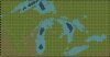
Bare map with hills, trees, and resources turned off:

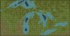
Map with hills and trees turned on:

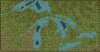
Map with all features turned on:

I laid out each hex using an overlay of Google Maps so the landmasses, rivers and lakes should be very accurate. Below are some pictures of the map with various layers turned on.
Bare map with hills, trees, and resources turned off:
Map with hills and trees turned on:
Map with all features turned on: