OMG! All 3 maps of 1900 I've already found are wrong, how can this be? I remember when I was at school and teachers were explaining us about the Paraguay War or War of the Triple Alliance. It was a war where Brazil, Argentina and Uruguay allied against the Paraguayan dictatorship because their Dictator wanted to increase Paraguay's borders on Brazil.
What was funny though is that
all maps were historically wrong on our official books. I found that because of this:
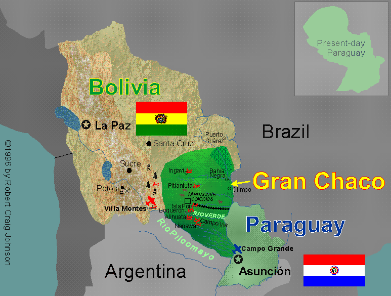
This is a map of the Chaco War (1932-1935) between Paraguay and Bolivia. Paraguay was the winner and got that huge part for it. But all maps displayed to us already had that part, and Paraguay was displayed exactly as it is today.
And all maps that I found now in my quick search do that as well.
This will be harder then it looks, but I may guarantee to you a good map of South America.
BTW, do you have an idea which countries of South America your map will have? Just to make things clear I'll give a list of possible candidates:
1- Arentina
2- Brazil
3- Colombia
4- Venezuela
5- Uruguay
6- Bolivia
7- Chile
8- Ecuador
9- Peru
10- Paraguay
I think Argentina, Brazil, Colombia, Venezuela, Peru and Bolivia are a must by their sizes. If you put less then 6, take away Bolivia first, then Venezuela and then Colombia.
If you may put more, Chile deserves for importance. Soon after Uruguay. Ecuador and Paraguay come next in any order.
The rest didn't appear until after 1950, Guyana and Suriname. And French Guyana is still french today.
Oh, and BTW searching for info I found a detailed site about it:
http://alabamamaps.ua.edu/historicalmaps/index.html
It's hard to view the maps, but at least is the most accurate I've seen up to now
