An Atlas of Rhye's World

Lord Oden

WarLord
Joined
Jun 20, 2001
Messages
105
Location
Ancient Lurker - Ole Texas Republic
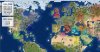
A great game needs a great map.

Therefore I give you Lord Oden's Atlas to Rhye's world v_W1.04.

Most great generals will not go to war with out the proper map and the thumbnails simply will not cut it.

This is a jpeg image (3746X2046 495Kb) stitched from several flying camera shots.

Unfortunately to meet the 500Kb limit for a forum post it had to be severely compressed.

However if Rhye or anyone else wishes I can send them the uncompressed 6Mb file to be released.

Merry Christmas

Lord Oden
 

Attachments

  • Atlas_Rhye_Clean3.jpg
    Atlas_Rhye_Clean3.jpg
    496.5 KB · Views: 12,746
Hey nice work there buddy :thumbsup:, perhaps one can develop it even more by noting the areas of civs and their leaders on the actual map, naming important seas and rivers and maybe even give the timelines for the continents' civs. Then we would have a respected 'Atlas' PDF to go with the mod.
 
Hey nice work there buddy :thumbsup:, perhaps one can develop it even more by noting the areas of civs and their leaders on the actual map, naming important seas and rivers and maybe even give the timelines for the continents' civs. Then we would have a respected 'Atlas' PDF to go with the mod.

I would be willing to mark all the civ areas since I've already done it for each civ in paint for my own purposes. But, I can't do rivers, timelines, leaders, etc. I would be willing to put regions on there, e.g. France must settle the Hudson/Quebec and I could label that region.

Also, if you need a larger image storage, use imageshack.
 
At first I didn't know what this was about, but now I realise it's a great idea. You could make it dynamic and display flip zones, specific city locations for UHV goals, final resource locations, etc. and it would be a wonderful resource.
 
At first I didn't know what this was about, but now I realise it's a great idea. You could make it dynamic and display flip zones, specific city locations for UHV goals, final resource locations, etc. and it would be a wonderful resource.

Well, maybe YOU could.:)
 
The world would be a darker place if everything relied on me doing something.
 
At first I didn't know what this was about, but now I realise it's a great idea. You could make it dynamic and display flip zones, specific city locations for UHV goals, final resource locations, etc. and it would be a wonderful resource.
Wow, this could be grand, EPIC :cool:. With the use of an interactive program (say Flash), we can make it so that you can pick the 'layer' you want to display, and view all the info. (ie: civs, flip areas, timelines, historical victories, uus/ubs/ups, etc..)

Maybe I would do it someday, but don't rely on me, I have promised too many people and I'm tied up big time :crazyeye:.
 
Now that would be awesome indeed. The map by itself now is fine, actually, but if you were to add flip areas and that.. it would be VERY useful.
 
Good, yall are getting the idea. I supplied the original base map. If anyone wants to take it and add starting locations, UHV control zones, changes in resources, whatever, feel free. This thread could become an actual Atlas containing many different maps.

I considered doing a second map with the resources icons active before I realized that they changed with time.

The flash idea or different layers idea maybe a better solution to showing the changing resources.

I just mainly use the map to get a "big picture" strategy.

That and use it to plan a few steps ahead when I am not playing the game (cough..at work).
 
Please, for the love of God don't use Flash. Supply it as an HTML and collection of images and use Javascript or something (switch on different overlays).

Edit: I'll try to put a mockup of an HTML/JS system in a bit:
http://zepto-angstrom.co.uk/scrap/rfcmap/index.html
That'll only work in Firefox and Safari and maybe IE7 but it can probably be made more compatible.

Edit2: Updated a bit. My poor machine doesn't seem to like images that big.
 
not entirely correct.
you should include the tiles specified in tExceptions as well

Should be fixed now. Let me know if you see any mistakes or would like more data put on it. I was thinking about putting some regions on there like Hudson Bay.
 
Dafiden, do you mind if I copy it, separate it out into different eras of spawns and maybe pretty it up a little (at the possible risk of legibility?
(Well, presumptively, I've already started: http://zepto-angstrom.co.uk/scrap/rfcmap/index.html but if you want me to stop, please tell me.)

Nah. Knock yourself out. What I've done is probably all I'm prepared to do, with the exception of adding things the same way that I've already done, e.g. victory regions.
 
I've started doing those as well but I'm still not certain that I'm reading the co-ords correctly. (Origin at 0,0 and BR,TL does not mean Bottom-Right, Top-Left ; took me long enough to work that out).
 
I've put up what I think are the areas applicable to Russia, Turkey and France. Apologies if it loads slowly. Low quality screenshot is also supplied:
 

Attachments

  • Picture 1.jpg
    Picture 1.jpg
    345.9 KB · Views: 1,383
I've put up what I think are the areas applicable to Russia, Turkey and France. Apologies if it loads slowly. Low quality screenshot is also supplied:

So, how did you get it to look nice? I used Adobe Photoshop Elements.

Also, you may have forgotten the Carthage core area exceptions in Tyre.
 
Back
Top Bottom