timerover51
Deity
So, is it safe to download the 0.97 version, or better to go back one or two?
So, is it safe to download the 0.97 version, or better to go back one or two?


I want to make a "palette" of all terrains so that as I make map images they will already be in the proper colors to convert. Something like what I did for BMP2BIC. On the TERR tab there are 14 terrains listed.With the LM versions that's 28 vs. the 36 in the quote. I can't think what the others might be. There are the separate graphics files, such as snow/forest mountains & plains/grassland forests, but afaik those are not treated as distinct terrains - only as visual variations. Hope this doesn't sound nitpicky. I know during that phase of the development we were all trying to work out what terrains were possible, even theoretically. I just want to make a palette guide that will hopefully be of general use.There are now a full 16 "basic" terrains, as well as 20 more "advanced terrains", which cover (unless I've missed some) all land-based terrains in Civ3 as well as the water option. All Landmark options are in Advanced Mode.
Hmm, so I had better download 0.97 now for my older Mac then. Got you, and thanks again for all of your efforts.
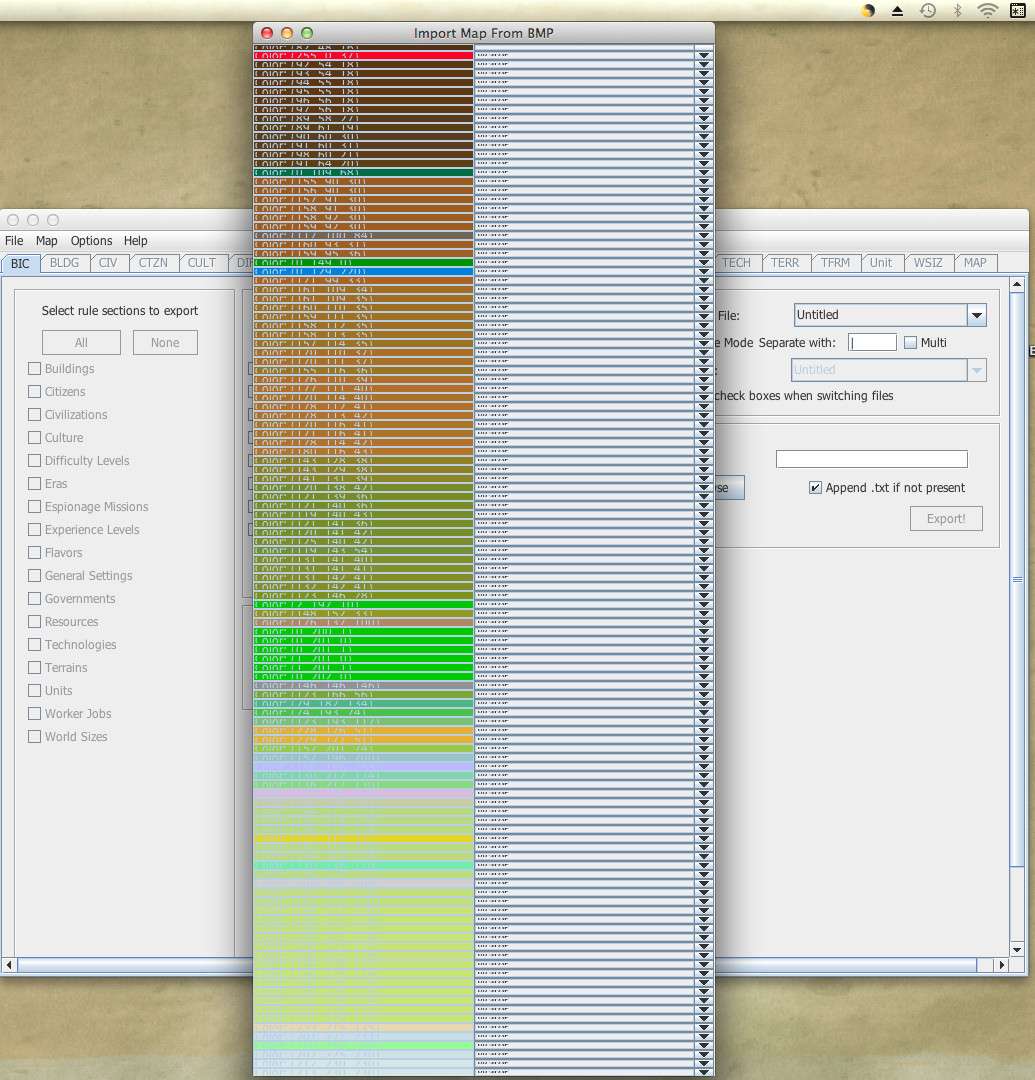
Thanks for the list & thorough explanation! I'll be making a little graphic table with my chosen colors. Eventually I want to update my old map-making tutorial with it, info about your editor, and some other streamlining of the process. In the meantime I could post the chart here if people would find it of use as an example.So, the editor's BMP import functionality assigns each color a terrain that's based on the graphics file that will be used, and also supports the landmark version of those. ... the option to be more specific is there if you do have source material that distinguishes that.
Automating initial water placement is well worth the freedom and range gained in mapping other terrains. I usually end up "paintbrushing" the water types away from the coast anyway.... The way the [editor] works is that all "Water" that borders land is coast; after that, all "Water" that borders only other water and coast is Sea, and finally all water that borders only other water and sea is ocean. There isn't currently a way to specify that a large area of water should all be coast or all be sea ...

 Sorry if the retyped replies are somewhat shorter! I also plan to edit this post to add to it so that I won't lose all the replies if it crashes again.
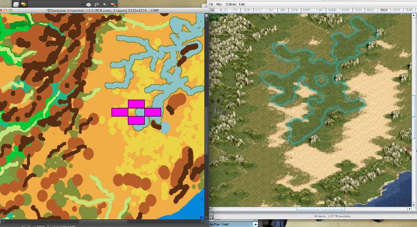
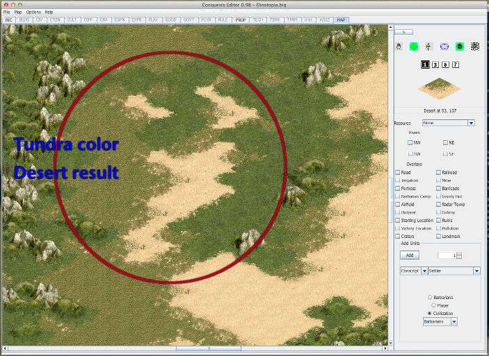
Decided to try a 16 color bmp, since the map had fewer terrains. An unexpected result -
Tundra color chosen in palette dialogue resulted in Desert on created map. It's important to note that the colors were very different pastel violet vs. orange-yellow:
Spoiler :
Also, tried a trick that should be helpful in editing. Left "Ocean" & "Coast" both as Water, but made "Sea" LM Water. Usually paintbrush the water in broad strokes anyway, so the LM markers will serve as a guide. First change LM to Sea then everything next to coast to Coast.
Spoiler :
not sure how well a biq survives zipping - just in case it's useful Dinotopia WIP
Blue Monkey said:worked out a palette, used it on a map wip, imported, associated terrains with colors, map creates just fine. I didn't like some of the distortions caused by the conversion - I need to think about proportions differently for this editor vs BMP2BIC. So I reworked the image - made sure the new version was indexed. This is what I get for the color assignment dialogue:
Spoiler:
Not good.
Tried -
quitting & restarting editor. Same result
trashing the temp files such as the bmpcolor txt, the log, the autosave. restart editor. same result.
re-indexing the image. restart editor. same result.
EDIT: While doing further experimentation, went bck and opened another bmp that had worked before. It was fine, so must be something about how I indexed that particular image, not with the editor.
working with GIMP 2.8.10p2 under OSX 10.9.5
Blue Monkey said:Thanks for the list & thorough explanation! I'll be making a little graphic table with my chosen colors. Eventually I want to update my old map-making tutorial with it, info about your editor, and some other streamlining of the process. In the meantime I could post the chart here if people would find it of use as an example.
Kestrel18 said:Following on from my last post above, about the Export to CSV feature minor bug.
One enhancement I would LOVE to see (in the fullness of time and if you ever feel so inclined) would be an "Import from CSV" feature for units.
This would enable modders to export the units statistics for an existing mod-pack/scenario biq, import the CSV to Excel, and then (for example) double all the Attack and Defence and Bombard stats (so as to allow greater nuance in creating and inserting new units), export again to CSV and then re-import into the biq with all the changed numeric values in one step.
It could also be used to modify any of the other numeric values currently exported by the editor (movement, hitpoint bonus, cost etc.)
The only other way I currently know to do this would be to change each and every numeric setting, step by step for each and every unit. (Does anyone know of another, more efficient way ?)
In the old Civ2, the statistics for units were held in a text file, so it was easy to perform such a global change with a bit of minor massaging.
An 'item' by 'item' editor such as was provided with Civ3 always seemed to be to be a bit of a backward step, even though the interface was prettier.
Great Editor !
One Minor Bug Report. Not sure if it has already been reported (with 28 pages of replies so far, it probably has) so apologies if I am double-reporting.
In the Option "Export to CSV" the "Prerequisites" column, when "Include Technologies" is ticked, the export only displays multiples of the first tech required for that subsequent tech advancement - For Example ;
Tech Name........ Era.............. Prerequisites
Mathematics......... Ancient Times.... Masonry and Masonry
Map Making.......... Ancient Times.... Writing and Writing
Horseback Riding.... Ancient Times.... The Wheel and The Wheel
The Republic.........Ancient Times.....Philosophy and Philosophy
Monarchy............ Ancient Times.... Warrior Code and Warrior Code
Construction.........Ancient Times.... Iron Working and Iron Working
Chivalry............ Middle Ages...... Monotheism and Monotheism
Invention............Middle Ages...... Feudalism and Feudalism
Democracy............Middle Ages...... Printing Press and Printing Press
...and so on.
For Mathematics (in standard 'vanillla' Civ 3 Conquests) it should be ; Masonry and Alphabet.
Cheers.
You're right on both counts. I can redo the smaller area with grass surrounding. I often use tundra as a placeholder for unusual terrain - my fault for forgetting the limitation. & the larger area was desert.I suspect what's happening is related to the plains nearby, and tundra not being allowed to border plains. The bmp-import process does have code to avoid any illegal-in-Civ3 neighboring terrain. ... Was the larger desert to the southeast supposed to be desert, or tundra?
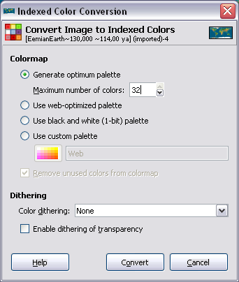
The bmp was meant to have 256 colors. Double-checked that when reindexing. But as stated in the edited comments - there may be a problem with the file since other bmps indexed from the same selection of colors both before and after worked fine.It looks like I need to either add a scroll bar to the color-mapping window, or add a limit on the number of colors, or both. It appears that the file in that screenshot really did have 256 colors; it's possible to limit the palette to a number between 16 and 256 in GIMP, and that's what I generally recommend and have been doing.
 ) . Could also post the palette itself I guess, if there's any interest. Pretty sure GIMP can export a palette. Got to think of tiles as pixels. One tile = one terrain = one color.