A lot of things about Africa
I spent a lot of time looking at Africa. Here are my thoughts and suggestions.
To explain what I did, I first covered the whole continent with culture following modern boundaries, taking the coastline as the only reference to know where each country stands. I compared each country to their real life counterparts.
I noticed two regions that don’t look quite like the real life counterparts: The Swahili Coast (it’s too short vertically) and Southern Africa (too small, vertically and horizontally, plus the Eastern coast doesn't look very accurate. I also noted some minor changes for the coastline in Western Africa, but didn't get to do those yet (will come later).
I also wanted to make better terrain for all the civs playing there. For now, I focused on Egypt and Ethiopia, and also looked at the terrain in Tanzania/Kenya thinking of the Swahili. I want to look also at Nigeria, Mali, Zimbabwe, South Africa, and the Congo, but didn't get to those yet.
As a disclaimer I did not look
at all at resource placements. I placed recommended cities. On the Nile, the Ethiopian highlands, the whole Eastern African coast, and eastern South Africa, I favored more rather than less cities, shifting several of them 1tile outside of their real position (but still being accurate) to accommodate this. I can also see how to fit less cities could work so I can also change everything to show that instead.
The Nile Valley
I moved the whole Nile valley 1W and reworked the river to include very pronounced bends all the way onto Sudan. The bends follow the actual course of the river but in an exaggerate way to increase the reach of the river. I also added a land tile (80,45) to expand the delta area.
I removed a mountain on the Red Sea coast (presumably there to block founding a city that can both be on the Nile and the Red Sea) and changed the whole coast into hills to represent the region’s topography better. I moved the The “bump” in northern Libya/Egypt that is home to Benghazi and Cyrene 1W as well.
These changes are all meant to increase the area available for cities. I tried to accommodate 5 in Egypt and 3 in Sudan. Some of the cities are shifted a tile from their real location, but I think it’s worth it. For example, Aswan should be 1E, Meroe 1E, and Khartoum 1NE. The move westwards allows for a larger Ethiopian area (see below).
The changes come at the expense of some of the desert, 1 tile of Libyan coast, and squishing a bit the South Sudan area.
I haven’t: checked the distribution of floodplains, someone else can do that, but here's how it looks like with the cultural borders updated to the changes:
Horn of Africa
There’s only one change in the coastline: adding a tile NE of Axum (85,36) to landlock the city. I moved Lake Tana 1W and redesigned the interior to increase the playing area (benefitting from the shift of the Nile). This does not increase the number of cities, but allows more land for Ethiopia to work and better represents the fertile Amhara and Oromo regions of the country. To enlarge the highlands, I converted some plains into grasslands hills (82,35 (ie, Gondar) and 81,34) in the west).
I also looked in detail at the whole mountain ranges of the Rift Valley, because the mountains seemed too much. From topography maps, it looks like many should rather be hills, so I left only the highest regions as peaks. In Ethiopia, I left a mountain on each side of the Ethiopian Rift, ie, one Southwest of Lake Tana representing the Shoa and Gojam highlands; one southeast representing the Arsi Bale highlands. I also turned the northeastern “funnel” shape of the Rift Valley as plains (ie, the area in front of Yemen). I removed the other mountains in the region (1 from the Somalian coast, 2 from the Turkana Pass) as they didn’t seem to be justified by the topography.
I also added plains and grasslands to Somalia, I was impressed after seeing pictures of the Jubba river and satellite images of the coastline. Mogadishu itself I made plains, but starting from the next tile all the Swahili coast all the way into southern Tanzania is grassland (and plains immediately after).
Here's what this looks like, with the cultural borders adjusted to the changes:
Great Lakes and Swahili Coast
Here I focused on the mountains, the terrain types and the shape of the coastline.
As I mentioned, Tanzania looks too short vertically compared to real life, so added an extra row to it (ie, I took a 12x11 square starting on 79,25 and shifted that 1S). I left the two islands (79,26 and 86,23) on their original locations. I added a land tile on 84,23.
As with the Horn of Africa region, I thought the mountains were too many, so I looked at topographic maps of there region. There were 8 mountains around Lake Victoria and Lake Malawi: 4 in Uganda / Kenya; two in Rwanda/Burundi, one on the Tanzanian shore of Lake Victoria, and one on the Tanzanian shore of Lake Malawi.
- For the mountains in Uganda/Kenya, I left only one representing the Eastern Rift on the Kenyan side. Uganda should be only hills and so should the better part of central Kenya.
- In Rwanda/Burundi, I left only the westernmost one, which blocks the access to the Congo basin. This allows allows having Kigali or Bujumbura (before all Burundi was a mountain).
- I removed one of the peaks in Tanzania, left the other one to represent the Robeho and Nguru mountains.
Based on satellite maps, I added grasslands and rainforest/forest mixes to Uganda, Rwanda and Burundi, as well as southeastern Tanzania/northeastern Mozambique. I added some grasslands to the Swahili coast (as mentioned above). The Tanzanian interior is a bit of grassland/plains mix now.
For cities, some are shifted from their best locations. Mombasa should be 1SW, Zanzibar/Dar es Salaam should both be a more south, but this configuration allows more of them. I marked all important trading ports and included major interior cities.
I haven't looked at rivers. Here's what it looks like with the other changes (cultural borders updated to map):
Southern Africa
The main problems I saw here were the shape of the eastern coastline, which was too plain, and that the region as a whole was too small. I took a 8x6 square starting on 73,16 and shifted that 1E. Then I took a 9x8 square starting on 53,70 and shifter that 1S. I also shifted Madagascar 1E to make room for all of this. 11x8 square on 85,22 moved 1E.
After the shifts, I reshaped the Mozambique coastline, and realized the region was still too thin, so added more plains tiles, on: 81,15; 80,14; 79,13; 79,12; and 78,11. I think the coast tile north of Cape Town does not look like the real coastline (I’d change it to land), but I’m leaving it as it is because I know it also looked like this in the original map.
The changes benefit South Africa, which can now have up to 5 cities. Mozambique can hold 4 ports. The changes are also very much in favor of Zimbabwe and Botswana. I placed Gaborone 1tile East of its proper location to give room to Pretoria/Joburg. Western Botswana is rather empty so the change is not too bad.
I haven’t: looked at the terrain, resources, relief, forests, rivers, etc. I indent to do all all of these, except the resources, over the weekend. Here's what it looks like for now:
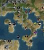
For comparison
Here's how Africa looks zoomed out, so you can see how the new shape looks like in relation to the rest of the continent.
Additional changes in Western and Central Africa coming later. Need to sleep now!
 1
1  and you can build most improvements on them; improvements take normal number of turns