Development Thread: Last Glacial Maximum Map (LGM)

Laskaris

Warlord
Joined
Nov 14, 2010
Messages
182
As we all know, Civilization IV came with an official Earth Ice Age map. Inspired by it, I started reading about this fascinating period in our planet's history. I had heard about the ice age, of course, but I had never studied it in any detail. I soon became thoroughly absorbed by the subject. I also realised that the original Civilization IV map, though fairly fun to play, contained a number of errors. I decided that I would try to create a better one, and a bigger one as well.

My map will portray the Earth as it looked like some 20.000 years before the present time, at the Last Glacial Maximum (LGM), the peak of the last ice age. The great thing about an Earth map like that is that it is both familiar and alien. You recognise all the continents and basic shapes, but there are giant ice sheets that cover large parts of Europe and North America. There are some additional land masses resulting from the lower sea levels, like Sundaland. There are different lakes and rivers. Most importantly perhaps, the vegetation looks totally different from what we have today. How would human civilization have developed if it had started developing during that time? It is a tantalising question.

A lot of our knowledge of the Last Glacial Maximum is still tentative. I will try to use the best scholarship that is available on the web, but on many things, as I know by now, there simply is no consensus in the scientific community. What was the exact extent of the ice sheets? Were there ice-dammed lakes in Siberia during the LGM or not? Where did trees grow, and how widespread were they? My design philosophy will be that, whenever there is an open issue like that, I will go with the option that is more interesting in terms of gameplay.

I originally planned to use Genghis Kai's Giant Earth Map (GEM) as a base. But as that was a typical Civilization map which unrealistically enlarged Europe and Japan, areas which are mostly tundra during the ice age, I have now decided th build my own map from scratch. The size will be comparable to the official Civilization IV Earth map, not gigantic. I might still do a gigantic map later on depending on how this first project works out and what feedback I get.

Since it will take me some time to make the map, I thought I would accompany the development with this thread here, which will allow me to gather feedback and suggestions while I go along. I hope that you will find the project interesting.

Development Chapters:
I. Coastlines
2. Climate and Vegetation
 
Sounds interesting.
Might I suggest that you post screen shots along the way?
Start with a screen shot of GEM, and every time you post to report progress, post a screenshot of how it looks now (in case you weren't planning to do so anyway).
 
Sounds interesting.
Might I suggest that you post screen shots along the way?
Start with a screen shot of GEM, and every time you post to report progress, post a screenshot of how it looks now (in case you weren't planning to do so anyway).

There will be plenty of screenshots along the way.

While we are on the the subject: how do you take a screenshot of a full map, like the one that is shown at the beginning of the GEM thread? I haven't figured that out yet.
 
Two suggestions:

Don't have any starting locations in the cold regions. All "civilizations" should be located in the warm regions of the world, while only barbarian units would roam the ice and tundra. So the cradle of civilization wouldn't be the rivers we're accustomed to, but some other ones. (Wasn't there some advanced culture in the Amazon waay back?)

Does the time frame of the map/mod/scenario include climate change? Because it would be possible to script this with some Python code - land rising from the sea, ice ever withdrawing towards the poles, tundra being replaced by plains and later grassland, terrain features like forests cropping up and covering the vast taiga, new resources spreading over the new territories inviting settling and exploration. This process could even be made somewhat random, so there would never be two identical games as far as the map development goes. But the end result would always be (more or less) the same - something reminiscent of the world atlas we know (but of course colder and more savage). So I guess we're probalby talking about a game that spans 20 000 BC to 10 000 BC or something. I'd imagine that civilization would have slower start in a less hospitable world, anyway.

And I could probable do the actual coding for this - if I have the time. It does sound like a fun project, anyway. :goodjob:
 
Don't have any starting locations in the cold regions. All "civilizations" should be located in the warm regions of the world, while only barbarian units would roam the ice and tundra. So the cradle of civilization wouldn't be the rivers we're accustomed to, but some other ones.

Yes, the starting locations of civilizations will be in hospitable regions. Obviously, you can't start out in the middle of the tundra or, even worse, an ice sheet.

(Wasn't there some advanced culture in the Amazon waay back?)

There are some theories which claim otherwise, but the common consensus is that there were no humans in the Americas during the Last Glacial Maximum. They only migrated there later - when the Bering Strait was still crossable, but when the North American ice sheet had receded enough to allow passage ("Mackenzie Corridor" along the eastern flank of the Rocky Mountains).

I am planning to do two versions of the map - one where there are no humans in the Americas, and one where humans have already migrated there.

Does the time frame of the map/mod/scenario include climate change? Because it would be possible to script this with some Python code - land rising from the sea, ice ever withdrawing towards the poles, tundra being replaced by plains and later grassland, terrain features like forests cropping up and covering the vast taiga, new resources spreading over the new territories inviting settling and exploration. This process could even be made somewhat random, so there would never be two identical games as far as the map development goes. But the end result would always be (more or less) the same - something reminiscent of the world atlas we know (but of course colder and more savage). So I guess we're probalby talking about a game that spans 20 000 BC to 10 000 BC or something. I'd imagine that civilization would have slower start in a less hospitable world, anyway.

And I could probable do the actual coding for this - if I have the time. It does sound like a fun project, anyway. :goodjob:

Thanks for the offer. It certainly would be a very interesting and dynamic game to have a global warming process like that. I thought about the idea myself already and I might work on it in the future. First of all, though, I will simply do the map, which is enough work in itself. Then I can think about other things.

So, the first version will be a kind of "static" ice age that doesn't go away. Let's say for the sake of the argument that the axis of Earth has a slightly different tilt, and that as a result, the Earth is caught in a neverending ice age that has conditions just like the Last Glacial Maximum.
 
If you wanna "explain" the lack of climate change, then you can always set the game to only span one millennium or something. Hardly noticeable on a "geological time scale"...
 
During the Last Glacial Maximum, huge masses of water were frozen in the ice sheets that covered much of northern Europe and North America. As a result, the global sea levels were approximately 120 meters (394 feet) lower than they are today. Coastlines looked different all around the world - in some places, where the shores are steep, there were only minor changes, but in others, where the sea is shallow, entire subcontinents existed that are now submerged.

You can find many maps on the web that depict the LGM coastlines, but most of them are pretty inaccurate, even the ones from scholarly sources (because they focus on other things than the exact shorelines). The best source that I have found, by far, is the open-source program NASA World Wind. There is a sea level-addon for it which has an option that shows the sea levels during the LGM, 120 meters below present. I also installed another addon that overlays present day coastlines and country borders. It makes for an excellent modding resource.

Take a look at Europe with LGM coastlines, with present day coastlines and country borders overlayed in yellow:


Most of the North Sea and the Baltic Sea is land. The British Isles are a part of continental Europe ("Oh no!", thinks the Englishman). The landmass reaches all the way north to the Shetland Islands. By comparison, there is not as much change in the Mediterranean. The most noticeable is that about half of the Adriatic is dry land. The Italian "boot" is less pronounced as a result. Corsica and Sardinia are connected and form one big island. The Bosporus Strait and the Dardanelles Strait are closed, so there is no connection between the Mediterranean and the Black Sea. The Black Sea was a huge freshwater lake during the LGM.

However, there was no land bridge between Spain and North Africa. The Strait of Gibraltar was narrower, but it was still there. This was one of the more obvious mistakes of the original CivIV Earth Ice Age map.

Here is a first look at my European coastlines from the world builder. The terrain I added is desert, which is just a placeholder, obviously. The "Dogger Bank" landmass in the north:


And a look at Italy and Greece:


I have a small lake north of Wales and some "Baltic Lakes" in what was the Baltic Sea. They will be frozen over because the whole area is covered by ice, anyway, but it adds a bit more visual variety to the terrain.
 
Obviously, the biggest difference between the Last Glacial Maximum and today was in the distribution of the climate zones and the vegetation. This is also the area where I feel that I can make the biggest improvements over the original CivIV Earth Ice Age map. That map was fairly accurate in some places, not so much in others. Generally, I feel that it had too many forests. The LGM was not just much colder than today, but also drier, and as a result, trees were rare.

That said, there is a lot of uncertainty about the exact climate and vegetation in various areas of the world during the LGM. We sometimes have conflicting fossil evidence, different computer simulations of the paleoclimate yield different results, and so on. So every global reconstruction is a pretty vague guess. I will use the sources which I consider the most reliable, and when faced with a choice, I will make the choice that promises the most interesting gameplay.

My main sources will be the Global land environments since the last interglacial website by the Oak Ridge National Laboratory and this paper by N. Ray and J.M. Adams.

Here is a look at the present-day potential vegetation of Europe (i.e. if there were no agriculture):

eur%28pre.gif


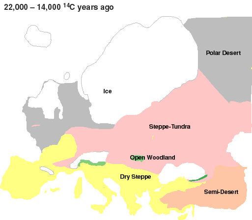
By comparison, Europe during the Last Glacial Maximum:

eur%2822-.gif


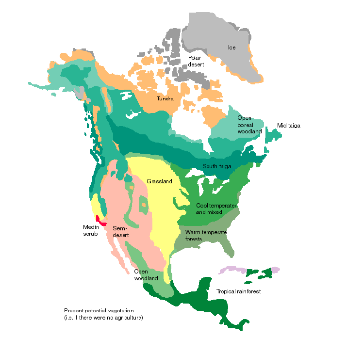
Present-day potential vegetation of North America:

NAprsnt.gif


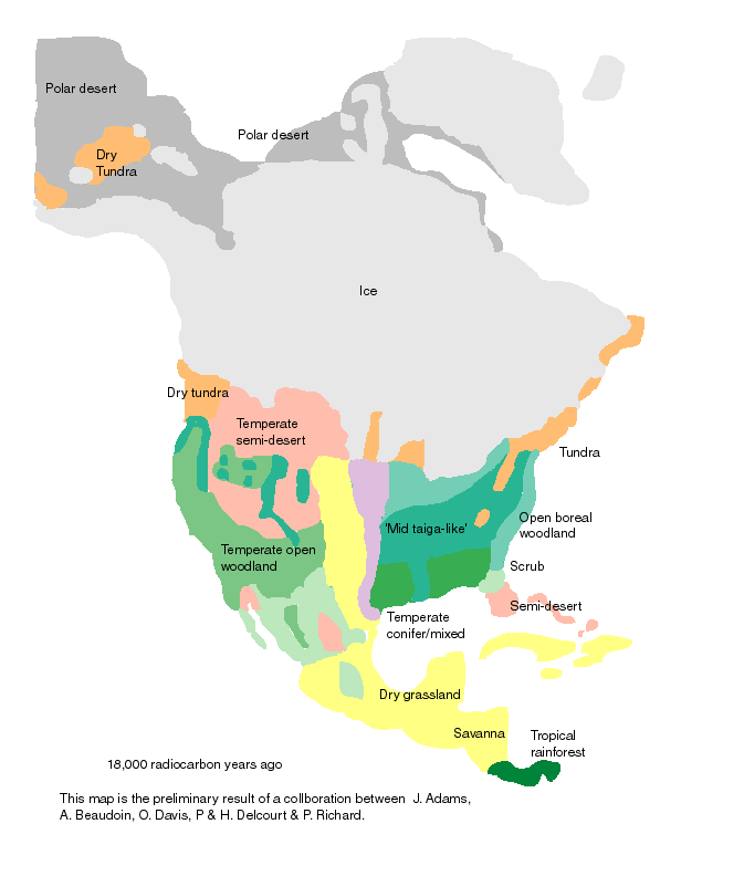
By comparison, North America during the Last Glacial Maximum:

NAL2215.gif


Does anyone fancy building a civilization on that map yet?
 
I have made a major change in my plans. On second thoughts, I have decided not to use Genghis Kai's GEM as a base.

GEM, like many other Civilization maps, enlarges Europe and Japan. This makes sense in a regular Civilization game where these areas of the world become very crowded. In a game set during the ice age, where most of Europe and Japan is tundra, it does not make sense at all. This is so obvious, I really should have realised it earlier. I am also unhappy with how geographically inaccurate the map is overall.

So, I have decided to make my own world map from scratch. Also, I will start with a smaller map than giant-size. I think that is more appropriate for a first map-making project. Later on, when I have the experience, I might still do a giant map.
 
Here's a thought: Do you really need all the Arctic and Antarctic regions, at all? Because if they're mostly covered with ice, those regions might as well be considered part of the polar regions. And for any future climate change scenarios you might as well make another map altogether.
 
Here's a thought: Do you really need all the Arctic and Antarctic regions, at all? Because if they're mostly covered with ice, those regions might as well be considered part of the polar regions. And for any future climate change scenarios you might as well make another map altogether.

That's a valid point and I have thought about it myself. However, I have decided against chopping off the north and south for three reasons:

1) I think the very point of an ice age map is to portray how different the world was from today. The player has to get a feeling for that. That is lost when you just chop off the north and south.

2) I still want surface ships, or at least submarines (depending on how much drift ice I add), to be able to go around the southern tip of South America. So in the south, I can't cut off much more than I would on a present-day world map.

3) If I do a full world map, I could also use it as a base for another one set during the present day.

So, I will cut off the map at roughly 60 degrees south and 75 degrees north, pretty standard for a Civilization map. With the kind of projection which most Civilization maps use, this would mean having huge masses of ice, because in those maps Greenland, Alaska etc. are unrealistically enlarged. However, I think I have found a great solution for this.

I will use an equal-area projection. Relations between the land mass area of the different continents will be preserved. Africa will really be much bigger than Europe. Greenland, Alaska and northern Siberia will be as small as they really are. And so on. It's the perfect projection for an ice age map, and one that I believe makes a lot of sense in Civilization, anyway (unless you are one of those players who insist on cramming 10 civilizations into Europe).

I will be using the so-called Hobo-Dyer projection.
 
Back
Top Bottom