Maps: Unit of Measurement

Gray Wolf

Winter Wolf
Joined
Jun 2, 2012
Messages
482
Location
Ravenswood
Ok, I cannot figure this out. Hopefully someone will know...

If a Map says it is 180x180 what is the unit of measurement for it? It can't be 180 pixels x 180 pixels. I looked for the answer everywhere and cannot find it.
 
Refers to the number of tiles.

Ok, I thought it could be tiles. But I'm trying to work something out...

See, I opened up a .BIQ file with a map and used Jing to cut a diamond tile out of a game map. Then I stripped all color out of the diamond and gave the diamond a yellow border.

Anyway, using Gimp and Filter/Map/Tile, you can generate a bunch of the tiles, however many you want. And my plan is to create a big Grid Layer of yellow diamond shapes. And make that a Grid Layer in Gimp. Then I want to add a real map image over top of the grid layer and save the image. Then I would have something good to go by to create the actual map inside Civ3Qedit.

So I'm trying to determine how many diamond tiles are needed for a particular width. And it seems like it is not a 1:1 ratio. For example, I just opened Kal El's 140 x 140 Earth map. And I counted the diamonds across (the width) and there are 70 diamond tiles going across...And I just counted the diamonds going down the height of the map and there are 70 diamond tiles going down...

So the 140 x 140 map is actually 70 tiles x 70 tiles.

Anyway, I'm trying to figure out a good way to make maps using a grid system within GIMP.

I'm not sure what my question is here. I think I figured it out. If I want a 180 x 180 map, I will need to generate 90 x 90 diamond shaped tiles.
This means that I will need to multiply the diamond image's width x 90 and it's height by 90 to get the filter/map/tiles height and width values.
 
Aren't the tiles counted in a zig-zag pattern since they are offset as a diamond pattern and not squares?

Well I'll be a monkey's uncle. :) You are very right. So that's why the 140 x 140 is actually 140 x 140 and not 70 x 70 like I said above.

That makes perfect sense.

But for the layer thing, I think I will need to use the math I described above (that counts the number of diamonds that go across linearly) which
w/b 90 for a 180 x 180 map image.

I'm going to keep playing around with this and figure out how to quickly make an empty tiled map as a layer in GIMP for whatever sized map a person wants to create.
 
I haven't been thinking right. All I have to do is this:

1. Create a map using GIMP.
2. Tile a diamond image to the same width and height of the map.
3. Add the diamond layer as a transparent layer over the map.
 
I haven't been thinking right. All I have to do is this:

1. Create a map using GIMP.
2. Tile a diamond image to the same width and height of the map.
3. Add the diamond layer as a transparent layer over the map.


** Potential Pitfalls

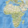
I did a post discussing the map design problems with understanding that tiles are single pixels even in game. One fundamental problem is that in .bmp the pixels are a square grid, while the Civ map uses a diamond shaped grid. Here's a post ,with discussion following on in further posts, illustrating the problems with converting a square, one pixel over another, image into the isometric tile-shaped maps of Civ. To get a decently shaped map the image had to be stretched taller, empty ocean colored bands added to make it square, then the empty ocean had to be cropped off, either in Map Tweaker or the editor, to make a usable map.


Grid Overlay Method
This Map Making thread has a good discussion of how to do a decent freehand map & works very well if the map is already a digital image, as you have. Be sure to read all two pages because several variations are discussed and the best ones (IMHO) come last. The biggest advantage is that you can do all kinds of shapes & sizes of maps. & The method doesn't depend on your level of artistic skill - just starting with a decent map & patient application of effort.
When I used the grid method I found it useful to create the grid with the tile dimensions I wanted, then scale to fit.

This is the grid I ended up making for myself using that automated site. I then added the rectangular part of the grid to make it easier to count 10x10 (5x5) blocks of tiles when designing the map.
 

Attachments

  • SquaredGrid.gif
    SquaredGrid.gif
    469.5 KB · Views: 99
When I used the grid method I found it useful to create the grid with the tile dimensions I wanted, then scale to fit.

This is the grid I ended up making for myself using that automated site. I then added the rectangular part of the grid to make it easier to count 10x10 (5x5) blocks of tiles when designing the map.

I read your map making notes and they were extremely helpful. I decided that I like the grid-layer method the best.

My approach is very similar to yours except I made a diamond.png file and then I use Gimp and do a Filter/Map/Tile command to make the diamond image tile itself to whatever size I need to cover my map.

So for example below, I tiled the diamond.png file to 510 x 520 (the size of my Africa map) and then added it on top of the Africa file as a layer.

Anyway, this seems to work ok as long as the tile command will tile to a very large size because most maps are going to have very large dimensions.

And another note about this. I think it would be better to print these out onto a4 sized paper so you can have a physical copy to work with rather than a digital copy... because I realized that it was a lot of trouble scrolling the digital image around and trying to count how many diamonds to the left/right/up/down something was at. It'd be a lot easier to just look at a physical copy sitting on your desk...
 

Attachments

  • Diamond.png
    Diamond.png
    394 bytes · Views: 45
  • Africa.jpg
    Africa.jpg
    53.2 KB · Views: 52
  • Tile Overlay.png
    Tile Overlay.png
    1 KB · Views: 58
  • Africa with Diamond Grid.jpg
    Africa with Diamond Grid.jpg
    60.8 KB · Views: 60
And another note about this. I think it would be better to print these out onto a4 sized paper so you can have a physical copy to work with rather than a digital copy... because I realized that it was a lot of trouble scrolling the digital image around and trying to count how many diamonds to the left/right/up/down something was at. It'd be a lot easier to just look at a physical copy sitting on your desk...
Yes. That is how I worked until I got better at using converters - Quintillus' editor is fairly flexible & gives good output even though it is a wip.
 
I am just an old school, MS Paint, Pixel by pixel map maker. Tedious, but exact. Usually have 2 images - 1 large, the other shrunk to the pixel-to-tile size. First pass I place all the tiles by pixel from the smaller image. Then I compare with the Larger image and tweak as needed. If a real place, Google Earth is great here. Then it is time to place things like Volcanoes and Rivers - Resources and Cities if needed.
 
I am just an old school, MS Paint, Pixel by pixel map maker. Tedious, but exact. Usually have 2 images - 1 large, the other shrunk to the pixel-to-tile size. First pass I place all the tiles by pixel from the smaller image. Then I compare with the Larger image and tweak as needed. If a real place, Google Earth is great here. Then it is time to place things like Volcanoes and Rivers - Resources and Cities if needed.

Sounds like you have a good system for making maps. It's all pretty hard to me, so I'll probably just use someone else's map.
 
Back
Top Bottom