molesworth
Warlord
In this and my next two posts I have attached three maps that might be of use to anyone designing a Norman Conquest era scenario. I have certainly found them useful for a Battle of Hastings scenario that I am working on. The maps show geographical feaures of England and Western Europe around about 1000AD and so would also apply to creation of Viking scenarios.
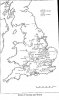
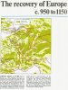
The "Swamp and forest" map shows the distribution of these features in Anglo-Saxon England and is taken from the 1996 edition of The Anglo-Saxon Chronicles edited by Michael Swanton. The "MedievalEuropeForest" map, attached to my next post, shows the distribution of forested areas in Western Europe. It is taken from The Times Atlas of World History. Unfortunately it does not include Western France. In my third post I will attach a map which covers this area.
I hope these maps might be of use in the creation of authentic scenarios.