Polar Maps

What Do You Think

  • Good Concept

    Votes: 66 65.3%
  • Silly Concept

    Votes: 12 11.9%
  • Probably won't use them

    Votes: 37 36.6%
  • Probably will use them

    Votes: 24 23.8%

  • Total voters
    101

Crayton

King
Joined
Jul 18, 2004
Messages
698
Location
FLORIDA
Cylindrical maps are all well and good, but how about polar maps. These 2 Map Scripts generate maps centered on one pole and extending to the other. Both maps have x and y wrapping.

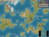
The Circle script generates a diamond-shaped pole in the center and at the four corners.

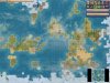
The Eye script generates a square pole in the center and one bordering the edge of the map.

Of course, both script generate tropical zones as well. Personally I enjoy the Circle script because the Eye script may have too much ice in the center.

Save these in your "PublicMaps" folder as .py , don't worry no files will be replaced. Post what you think and give suggestions for alterations or new maps. :)
 

Attachments

Nice to see somebody else who cares about map projections. I have been comparing cylindrical projections and it amazing how many different ways they space the latitudes. By spacing the latitudes differently, you can get equal area, conformal, and (partially) equidistant maps.

Polar co-ordinates are cool too! :goodjob:
 
I too am excited about the many possibilities when it comes to map-projections. Here are screenshots from the two scripts: Small Islands, Low Sealevel.
 

Attachments

  • circle.JPG
    circle.JPG
    79.8 KB · Views: 1,760
  • eye.JPG
    eye.JPG
    84.3 KB · Views: 1,526
This is quite interesting. I am interested in a torroidal world (N wraps to S, E wraps to W) for another game. These projections help with visualisation. I'm going to play around with it. Thanks.
 
How do you use this text document? Just put it in the Python folder in assets? I want to use it for a mod, except I will change the grid dimensions and only use Y wrap.
 
Put it in your "PublicMaps" folder. You should see existing files such as Archipelago, Balanced, Continents, etc.... Save these text files in this "PublicMaps" then change the extention to .py
a simple way to do this is to open the file and save it as, for example, Circle.py in the "PublicMaps" folder.

I hope this helps. To change the wrapping just scroll own to line 60 or so and change GetWrapX() to return False, or however you desire to change it. Have Fun.

EDIT: I said "Public Maps" too often. Sorry, I know you are not stupid ;)
 
No, I AM stupid. I had figured that out and was coming back to edit my question into something innocuous, like, "Great work, keep it up," before anybody saw it, but to my dismay you had answered. There is no excuse. I have loaded maps for mods there, I should have known. Thank you very much. Now, probably an inappropriate place to put such a question/request/idea:
is there any way to make the map generate differently in defined areas? What I mean is, something like latitude, except instead of just generating more ice and tundra at high latitude generate different kinds of maps. Like, a pangea in the area from x=0 to x=10 and an archipelago of small islands from x=11 to x=20.

P.S. Edited in Later: I think Oasis does something like that, I'll try to eventually figure it out from that, thanks.

PPS Even Later:
Plus there's practically a tutorial in the comments in
CvMapGeneratorUtil.
 
are YOU Warlord compatible?!?

Sorry. :D As far as i've seen so far any map script will work on any type of civ 4, no problems at all.
 
I like it, though I did make it square. Also pangea and massive continents seems to just give a massive blob of land crammed in one corner while the rest of the map is a vast empty ocean.

I'll be sticking to islands, this looks like it would make a great multiplayer map.
 
I took a look at the map, & I find worrying the following:

-No jungle
-No jungle-exclusive resources (sugar & dyes)

I do like how the landmasses are--their shape, topography (minus some mountain-blocked isthmuses) & hydrography.
 
Back
Top Bottom