Verge
Let's hug it out
The original Astronomy Picture Thread is buried deep in Off-Topic, so I thought it would be fun to start anew here in the Science/Technology forum Thunderfall has created for us! 
As the thread suggests, this is a place where you can share astronomy pictures that you have found in the news or simply find interesting enough to share. Where possible, try to include the subject--and perhaps a description--of the picture so we know what you're talking about.")
I'll start with some of the latest images from the HiRISE (High Resolution Imaging Science Experiment) camera that is currently taking pictures of Mars from the Mars Reconnaissance Orbiter. All of these images come from the official HiRISE website, at the University of Arizona.
Potential Landing Site in Nili Fossae

Clay Minerals in the Northwestern Bosporos Montes

Potential Landing Site Near Mawrth Vallis
Sources of Balsaltic Sand

The Aurorae Chaos

As the thread suggests, this is a place where you can share astronomy pictures that you have found in the news or simply find interesting enough to share. Where possible, try to include the subject--and perhaps a description--of the picture so we know what you're talking about.
I'll start with some of the latest images from the HiRISE (High Resolution Imaging Science Experiment) camera that is currently taking pictures of Mars from the Mars Reconnaissance Orbiter. All of these images come from the official HiRISE website, at the University of Arizona.
Potential Landing Site in Nili Fossae
The Nili Fossae are valleys that have cut into the ancient crust of Mars, exposing clay minerals. These minerals formed in the presence of water and may be the result of chemical reactions between hot water and rocks. If so, this could have been a favorable location for Martian life in ancient times.
This HiRISE image is part of a series in search for a safe place the Mars Science Laboratory rover can land. In the central part of the image, the terrain is a mix of sand dunes and relatively smooth rock exposures. There are some small knobs but very few large rocks in the area. Instead, the multi-colored rock exposures seem to be mostly a mosaic of flat fractured rock.
On the southern edge of the image, an impact crater is a potential hazard. In the northern part of the image, the scarp marking the boundary of the valley is visible.
Clay Minerals in the Northwestern Bosporos Montes
The Bosporos Montes make up part of the rim of the giant Argyre impact basin on Mars. The Compact Reconnaissance Imaging Spectrometer (CRISM) identified this as a location with clay minerals. Such minerals contain water and may have formed under conditions favorable for life.
This HiRISE image was taken to support the CRISM Team’s investigation of this area. While HiRISE does not have the ability to identify minerals the way CRISM can, the enhanced colors in this image are similar to those seen in other clay-containing parts of Mars.
The light-toned mesas and plains are crisscrossed with small fractures that could have formed as a muddy clay deposit dried. However, this material is strong enough to form boulders where it has been hit by impact craters.
Potential Landing Site Near Mawrth Vallis
Mawrth Vallis contains clay minerals that formed by chemical alteration of rocks by water. It is one of the short list of potential sites that the Mars Science Laboratory rover will land at, and the HiRISE team is working to find a safe place to land in this area.
This observation shows a wide variety of scientifically interesting terrains as well as some potential hazards for landing. The central part of the image is dominated by light-toned materials with curving fractures of many different sizes. These fractures do not have a preferred orientation, indicating that they did not form in response to some regional stress pattern.
Instead, they formed by some more uniform process, possibly the drying of a thick mud deposit or the gradual rebound of the area as the overlying material was eroded away. The scattered mounds and sand dunes may or may not prove to be a danger, but it is reassuring to see that many of the impact craters have been smoothed out with a filling of wind-blown sand.
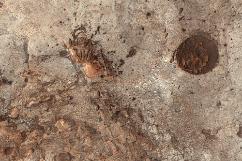
Sources of Balsaltic Sand
Sand dunes are among the most prominent wind-formed features found on Mars. Their morphologies depend on the winds and also on the local supply of sand grains, so they provide clues to the nature of both the Martian atmosphere and surface.
Dunes form through the accumulation of coarse sand grains carried by the wind by means of saltation, or bouncing along the surface. Monitoring the present day dune activity can help determine the timescale over which Martian rocks are eroded, as the impacting grains sandblast the surface over time. The sands of Mars must be continually replenished as the coarse grains are ground into fine dust by repeated impacts. Finding the hidden sources of fresh sand is a challenge for HiRISE.
This image was targeted at a point in Mitchell Crater in the southern highlands of Mars where sands abruptly appear and spread north. The sands seem to derive from the edge of an eroding mesa (shown here with an arrow; 8.66 kilometer, or 5.4 miles across). A close-up view of the terrain nearby suggests that boulders and sand have been excavated by erosion from beneath brighter, polygonally fractured ground (1.45 km, or 0.9 mi across).
This rocky layer may originally have been a lava flow; Martian lava flows are predominantly composed of basalt, which would account for the dark color of the sand. The polygonal pattern of the bright upper layer may be due to repeated freezing and thawing of the soil that buries the lava flow. The tracks of dust-devils are clearly visible on the smooth, sandy surface but largely vanish when they cross into the polygonally fractured terrain.
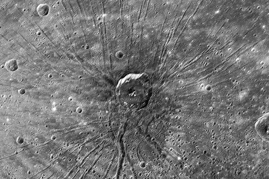
The Aurorae Chaos
This observation shows a portion of Aurorae Chaos, chaotic terrain east of the Vallis Marineris canyon system. Aurorae Chaos extends from Capri and Eos Chasmata on the west into Hydraotes and Aureum Chaos on the north and east.
Chaotic terrain is thought to form from subsurface collapse following volatile release. It is possible that the Martian crust was at one time enriched in ices that became gases or liquid at relatively low temperatures upon encountering a heat source or was violently shaken. These ices existed in spaces between soil particles. If a large volume of volatiles is suddenly released, then there is a large portion of the soil volume missing. The soil cannot support itself, so it collapses.
Since chaotic terrain is often located at the head of the Martian outflow channels (giant flood plains), it is also possible that the chaotic regions are the source of the fluids that formed the outflow channels. Aurorae Chaos connects to outflow channels via other chaotic regions.

")
 ) to move it.