KathleenArgent
Chieftain
- Joined
- Mar 7, 2018
- Messages
- 11
Hi folks!
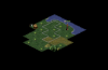
It's more something @TheNamelessOne should write himself, but since he's busy creating the new version of the Test of Time Patch Project, and he kindly allowed me to write something about what is coming up, I thought I could share something here which might be of considerable interest:
The next version of ToTPP, v0.16, will allow to draw arbitrary (bmp) images on top of the tiles of the Civ2 main screen.
I attached two screenshots where I played around with that - the graphics are terribly ugly of course, but I still find it very cool: I added an additional information table where one can assign tiles to a "territory". And if the neighboring tile is not of the same territory, then a border is drawn, in essence something similar to the Civ3+ cultural borders (at least if someone creates nicer looking graphics for that") )
)
The setting of the information itself is currently simply bound to a "key pressed", but that can of course be freely set in a scenario lua.
The beauty of the thing is that one can use that for dozens of possibilities of course - you could draw the Great Wall on tiles, or some other wonder, or have multi-tile cities, or what not. And it is completely independent of the underlying terrain, so you can utilize the terrains themselves in whatever way you want and then add bmps on top of it.
Hope some of you find that interesting enough to read this here
Best, Kathy
It's more something @TheNamelessOne should write himself, but since he's busy creating the new version of the Test of Time Patch Project, and he kindly allowed me to write something about what is coming up, I thought I could share something here which might be of considerable interest:
The next version of ToTPP, v0.16, will allow to draw arbitrary (bmp) images on top of the tiles of the Civ2 main screen.
I attached two screenshots where I played around with that - the graphics are terribly ugly of course, but I still find it very cool: I added an additional information table where one can assign tiles to a "territory". And if the neighboring tile is not of the same territory, then a border is drawn, in essence something similar to the Civ3+ cultural borders (at least if someone creates nicer looking graphics for that
)The setting of the information itself is currently simply bound to a "key pressed", but that can of course be freely set in a scenario lua.
The beauty of the thing is that one can use that for dozens of possibilities of course - you could draw the Great Wall on tiles, or some other wonder, or have multi-tile cities, or what not. And it is completely independent of the underlying terrain, so you can utilize the terrains themselves in whatever way you want and then add bmps on top of it.
Hope some of you find that interesting enough to read this here
Best, Kathy


 I expected a city with a boundary around it - but nevertheless it´s an interesting progress.
