michaelk156
Chieftain
- Joined
- Jul 24, 2010
- Messages
- 9
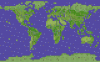
For the sake of added choice, I have created my own Earth map using Terraform. My aim was to make the continents and oceans accurate in terms of proportion. The map features Antarctica and Hawaii among other things not present on the other two Earth maps.
I would give a preview shot of the map, but I've included a little easter egg within it that would be given away if I were to show the whole map all at once. See if you can find it during play, I'm sure you'll be pleasantly surprised.")
Be sure to tell me what you think and how it holds up to the other two maps.
Edit: Slightly updated North America for improved accuracy. The revised attachments have replaced the older ones.
I would give a preview shot of the map, but I've included a little easter egg within it that would be given away if I were to show the whole map all at once. See if you can find it during play, I'm sure you'll be pleasantly surprised.
Be sure to tell me what you think and how it holds up to the other two maps.
Edit: Slightly updated North America for improved accuracy. The revised attachments have replaced the older ones.