abilard
Chieftain
Here is a map that is a modified version of UnCopain's excellent 107x87 Huge European Map. The changes that I made:
* Removed the bottom six rows... it was only Sahara Desert.
* Added Jordan River and Sea of Galilee
* Made the Dardenelles Navigable
* Made Venice an Island
* "Beefed" up Mountains: South Norway, Grampian Mountains (Scotland), Pyrenes, Systema Central (Spain), Systema Beticos (Spain), Alps, Balkan Mountains, Rhodope Mountains (Bulgaria), Northern Carpathians, Tatras Mountains (Poland).
* Added three historic Alpine passes using roads: St. Bernard's, Little St. Benard's, and Gotthard's.
* Changed hills around Bohemia... didn't "look" right to me.
* Made Agean Islands more "hilly"
* Added the oil fields of South Romania, Konigsberg, and East Slovakia.
This is only a map. No pre-set starting locations.
This is still a work in progress... more to come.
To see the original masterpice by UnCopain, visit th thread: http://forums.civfanatics.com/showthread.php?t=156846
View attachment ModifiedEurope.zip
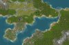
Alpine Passes:

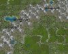
Dardenelles:

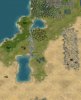
Sea of Galilee:

* Removed the bottom six rows... it was only Sahara Desert.
* Added Jordan River and Sea of Galilee
* Made the Dardenelles Navigable
* Made Venice an Island
* "Beefed" up Mountains: South Norway, Grampian Mountains (Scotland), Pyrenes, Systema Central (Spain), Systema Beticos (Spain), Alps, Balkan Mountains, Rhodope Mountains (Bulgaria), Northern Carpathians, Tatras Mountains (Poland).
* Added three historic Alpine passes using roads: St. Bernard's, Little St. Benard's, and Gotthard's.
* Changed hills around Bohemia... didn't "look" right to me.
* Made Agean Islands more "hilly"
* Added the oil fields of South Romania, Konigsberg, and East Slovakia.
This is only a map. No pre-set starting locations.
This is still a work in progress... more to come.
To see the original masterpice by UnCopain, visit th thread: http://forums.civfanatics.com/showthread.php?t=156846
View attachment ModifiedEurope.zip
Alpine Passes:

Dardenelles:

Sea of Galilee:


") btw: at bloody work most times, if I could Ill load up civ here...
btw: at bloody work most times, if I could Ill load up civ here...