Pickledtezcat
Chieftain
Here's a scenario I've been working on, My first for civ 4, though I used to make lots of stuff for civ 3 years ago on Civfanatics (can't remember my username or password though ") )
)
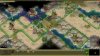
It's a modification of the 1000AD scenario bundled with the game, I've made a new world map, using an unusual projection method. I won't say any more as you may enjoy exploring a world where your traditional ideas of direction and orientation are completely switched around.
I've not done much playtesting on this one yet, but it seems to work OK. I used MapView 2.0 and The GIMP. Most cities are cut and pasted directly from the original scenario, but the map is all my own work. It's pretty huge (APROX 7000 plots), but the actual land area is cut down so if you're playing a European Civ you'd better get busy building colonies as the one or two cities you have at the start are not going to help you win the game.
I may post some other versions which can be played from the ancient era with 12 or 18 civs.
)It's a modification of the 1000AD scenario bundled with the game, I've made a new world map, using an unusual projection method. I won't say any more as you may enjoy exploring a world where your traditional ideas of direction and orientation are completely switched around.
I've not done much playtesting on this one yet, but it seems to work OK. I used MapView 2.0 and The GIMP. Most cities are cut and pasted directly from the original scenario, but the map is all my own work. It's pretty huge (APROX 7000 plots), but the actual land area is cut down so if you're playing a European Civ you'd better get busy building colonies as the one or two cities you have at the start are not going to help you win the game.
I may post some other versions which can be played from the ancient era with 12 or 18 civs.