It's possible that I should be posting this in the Utility Programs forum but I wanted to bring this to your attention anyway.
I got to know Rhye's BMP to WBS converter a few days ago and it occurred to me that it would be a good idea to find a hi-resolution image of the entire world and prepare a BMP file ready for conversion with Rhye's excellent little program.
What's the use of this? Given that there are already a number of good maps of the entire world, the purpose of my BMP files is not so much to make a full world map but rather to allow mapmakers to cut out *any* section of the world they want to make a map of, then convert it. This is great when you want a map of an unusual region or with an unusual combination of regions (say, South America including Western Africa). Then you just open my BMP files, cut out the section you want, then use Rhye's converter.
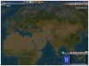
My BMP files are based on NASA's Blue Marble composite satellite image of the entire planet, 2048*1024 pixels (see attachment and screenshot).
Briefly about the limitations of this:
On the satellite image, ice, mountains and deserts have a number of white colors in common. Mountains in particular do not have distinct colors, since some are very green because of vegetation while others share many colors with deserts or tundra. The result is that there will be occasional patches of desert in the tundra and vice versa, and that mountain ranges are either partially or completely lacking. Same thing goes for forests and jungles. Some coastlines are also slightly distorted or may become distorted after the WBS conversion. Also no rivers or bonus resources are placed on the map at all. What all this means, basically, is that after the conversion you'll still have to edit your map to make minor correction to the coastline, the terrains, and of course to place rivers and resources.
Anyway, despite the limitations, what you'll get is a very quick rough map which will save you the hours and hours of work needed to make maps from scratch.
Quick instructions on how to use this:
1. Get Rhye's converter and learn how to use it (a nice .pdf help file is included)
2. Access each of the BMP files (height, terrain, feature) and crop the images to get the exact map you want; obviously you have to make sure you crop them using the exact same co-ordinates in all three.
3. Save the cropped images as separate files, then convert them with Rhye's converter. Steps 1-3 will take about 5 minutes and produce a nice sketch of a map!
4. Edit your WBS file with the worldbuilder or whatever map editor you like to make minor corrections and place rivers and resources.
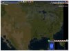
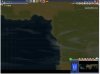
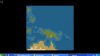
World height map
World terrain map
World feature map
Finally, a big thanks to Rhye for his excellent converter tool!
I got to know Rhye's BMP to WBS converter a few days ago and it occurred to me that it would be a good idea to find a hi-resolution image of the entire world and prepare a BMP file ready for conversion with Rhye's excellent little program.
What's the use of this? Given that there are already a number of good maps of the entire world, the purpose of my BMP files is not so much to make a full world map but rather to allow mapmakers to cut out *any* section of the world they want to make a map of, then convert it. This is great when you want a map of an unusual region or with an unusual combination of regions (say, South America including Western Africa). Then you just open my BMP files, cut out the section you want, then use Rhye's converter.
My BMP files are based on NASA's Blue Marble composite satellite image of the entire planet, 2048*1024 pixels (see attachment and screenshot).
Briefly about the limitations of this:
On the satellite image, ice, mountains and deserts have a number of white colors in common. Mountains in particular do not have distinct colors, since some are very green because of vegetation while others share many colors with deserts or tundra. The result is that there will be occasional patches of desert in the tundra and vice versa, and that mountain ranges are either partially or completely lacking. Same thing goes for forests and jungles. Some coastlines are also slightly distorted or may become distorted after the WBS conversion. Also no rivers or bonus resources are placed on the map at all. What all this means, basically, is that after the conversion you'll still have to edit your map to make minor correction to the coastline, the terrains, and of course to place rivers and resources.
Anyway, despite the limitations, what you'll get is a very quick rough map which will save you the hours and hours of work needed to make maps from scratch.
Quick instructions on how to use this:
1. Get Rhye's converter and learn how to use it (a nice .pdf help file is included)
2. Access each of the BMP files (height, terrain, feature) and crop the images to get the exact map you want; obviously you have to make sure you crop them using the exact same co-ordinates in all three.
3. Save the cropped images as separate files, then convert them with Rhye's converter. Steps 1-3 will take about 5 minutes and produce a nice sketch of a map!
4. Edit your WBS file with the worldbuilder or whatever map editor you like to make minor corrections and place rivers and resources.
World height map
World terrain map
World feature map
Finally, a big thanks to Rhye for his excellent converter tool!
")
