I have been working on a world map this past week, and was thinking that it would make things so much easier if Civ was played on a globe rather than a flat plain. There are lot of programmers here, what do you people think, would it be hard for Firaxis to do this?
The following is an interesting read on the subject - taken from an article online:
The fact that maps distort reality cannot be denied. It is absolutely impossible to depict a round earth on a flat surface without sacrificing at least some accuracy. In fact, a map can only be accurate in one of four domains: shape, area, distance, or direction. And in modifying any of these, our perception of the earth is affected.
There is currently a debate raging over which commonly used map projection is the best projection. Among a multitude of options, there are a few that stand out as the most recognized projections; these include the Mercator, the Peters, the Robinson, and the Goodes, among others. In all fairness, each of these projections has its strong points. The Mercator is used for navigation purposes because great circles appear as straight lines on maps utilizing this projection. In doing so, however, this projection is forced to distort the area of any given landmass relative to other landmasses. The Peters projection combats this area distortion by sacrificing accuracy of shape, distance, and direction. While this projection is less useful than the Mercator in some respects, those who support it say that the Mercator is unfair in that it depicts landmasses in the high latitudes as being much larger than they really are in relation to landmasses in the lower latitudes. They claim that this creates a sense of superiority among people who inhabit North America and Europe, areas that are already among the most powerful in the world. The Robinson and the Goodes projections, on the other hand, are a compromise between these two extremes and they are commonly used for general reference maps. Both projections sacrifice absolute accuracy in any particular domain in order to be relatively accurate in all domains.
Is this an example of maps creating reality? The answer to that question depends on how we choose to define reality. Reality could either be described as the physical actuality of the world, or it could be the perceived truth that exists in peoples minds. Despite the concrete, factual basis that can prove the verity or the falsehood of the former, the latter may very well be the more powerful of the two. If it werent, those - such as human rights activists and certain religious organizations - who argue in favor of the Peters projection over the Mercator would not be putting up such a fight. They realize that how people understand the truth is often just as important as the truth itself, and they believe that the Peters projections areal accuracy is - as the Friendship Press claims - fair to all peoples.
Interesting huh? (I am a geek what can I say)
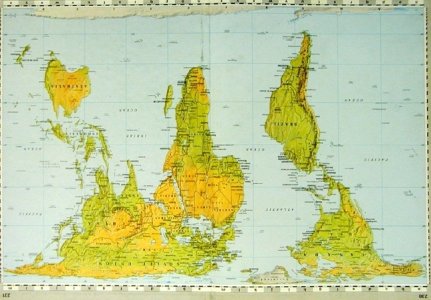
Anyway this got me thinking to change my map to an "Upside down Peters projection map", it would be cool cause we dont think of the world that way, though why not? In Australia they have maps where the World is upside down... its all relative...
here is an image of what it would look like - let me know what you people think:
The following is an interesting read on the subject - taken from an article online:
The fact that maps distort reality cannot be denied. It is absolutely impossible to depict a round earth on a flat surface without sacrificing at least some accuracy. In fact, a map can only be accurate in one of four domains: shape, area, distance, or direction. And in modifying any of these, our perception of the earth is affected.
There is currently a debate raging over which commonly used map projection is the best projection. Among a multitude of options, there are a few that stand out as the most recognized projections; these include the Mercator, the Peters, the Robinson, and the Goodes, among others. In all fairness, each of these projections has its strong points. The Mercator is used for navigation purposes because great circles appear as straight lines on maps utilizing this projection. In doing so, however, this projection is forced to distort the area of any given landmass relative to other landmasses. The Peters projection combats this area distortion by sacrificing accuracy of shape, distance, and direction. While this projection is less useful than the Mercator in some respects, those who support it say that the Mercator is unfair in that it depicts landmasses in the high latitudes as being much larger than they really are in relation to landmasses in the lower latitudes. They claim that this creates a sense of superiority among people who inhabit North America and Europe, areas that are already among the most powerful in the world. The Robinson and the Goodes projections, on the other hand, are a compromise between these two extremes and they are commonly used for general reference maps. Both projections sacrifice absolute accuracy in any particular domain in order to be relatively accurate in all domains.
Is this an example of maps creating reality? The answer to that question depends on how we choose to define reality. Reality could either be described as the physical actuality of the world, or it could be the perceived truth that exists in peoples minds. Despite the concrete, factual basis that can prove the verity or the falsehood of the former, the latter may very well be the more powerful of the two. If it werent, those - such as human rights activists and certain religious organizations - who argue in favor of the Peters projection over the Mercator would not be putting up such a fight. They realize that how people understand the truth is often just as important as the truth itself, and they believe that the Peters projections areal accuracy is - as the Friendship Press claims - fair to all peoples.
Interesting huh? (I am a geek what can I say)
Anyway this got me thinking to change my map to an "Upside down Peters projection map", it would be cool cause we dont think of the world that way, though why not? In Australia they have maps where the World is upside down... its all relative...
here is an image of what it would look like - let me know what you people think:

")


