As an earth scientist myself, I thought it would be interesting to explore the ideas behind the continents chosen. I heartily recommend the book
Supercontinent by Ted Nield if you have an interest in the ideas behind supercontinents, both mythical and scientific, past and prospective future.
They split into rough categories:
Current Political Continents
- Africa
- Asia
- Europe
- Australia
- Antarctica
...I hope I don't have to explain these
Combined Geographical Continents
- America is the contiguous landmass combining North and South America, ignoring the Panama Canal.
- Eurasia similarly combines the rather arbitrarily/politically defined Europe and Asia. We could also include Africa since there is a contiguous landmass there if we ignore the Suez Canal.
Geological Regions/Cratons
Cratons are old, thick and stable regions of the Earth's lithosphere (the combined crust and upper mantle, that form the tectonic plates involved in continent assmebly and breakup). They have survived many cycles of collision and rifting, and are now generally found in the interiors of tectonic plates.
- Laurentia, aka the North American Craton forms much of the core of the USA, Canada, and Greenland. It has been a separate continent in the past but is now confined to the North American tectonic plate.
- The Congo Craton, alongside the West African, Tanzanian, Zimbabwe and Kaapvaal cratons, form much of the modern continent of Africa. This is an odd choice since these cratons were formed 3.6-2.0 billion years ago and have been stable ever since, never a separate continent. Maybe there will be other cratons in the game?
Former Continents and Supercontinents in Geological History
A lot of the names come from supercontinents, both proposed and established. The Earth is believed to undergo periodic cycles where the tectonic plates combine into huge supercontinents, which then fragment, over vast stretches of geological time.
In the beginning, there was... what exactly? There are two (incompatible) theories:-
- Ur (good thematic name for Civ there) is around 3 billion years old and was probably the only continent on Earth at the time. Most of the Earth's crust was (and is) the denser, thinner oceanic crust. The lighter minerals had to fractionate out over time (in volcanic process) to form the landmasses we know and love.
- Vaalbara, if it existed, is a good 600 million years older, and comprised the Kaapvaal craton in southern Africa, the oldest crust on the planet (between 3.6-2.5 billion years old).
Then there is
Kenorland, at 2.7 billion years old is possibly the earliest proper "supercontinent", comprising what would later become Laurentia,
Baltica, western Australia, and more.
More cratons were accreting into continents,
Arctica, which would combine with Baltica and east Antarctica to form
NENA (Norther Europe and North America) and
Atlantica.
The patriotically named
Columbia formed around 2.1-1.8 billion years ago and assembled together nearly all the Earth's continental blocks. These once again accreted to form...
...Rodinia around 1 billion years ago. The exact configuration of these ancient supercontinents aren't known, and the evidence for them consists of select geological and palaeomagnetic observations. Rodinia, inevitably broke up and its pieces later reassembled to form...
...the
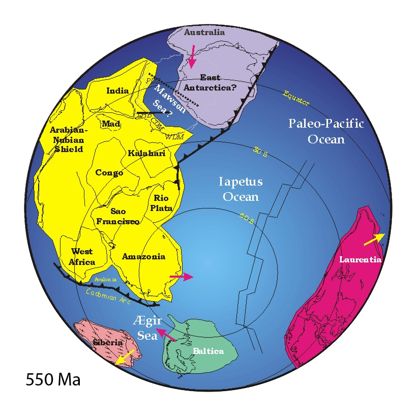
Vendian supercontinent (AKA
Pannotia) around 600-550 million years ago. This was a mayfly in geological terms, breaking apart 50 million years later, as the ancient Iapetus Ocean separated Laurentia and Baltica all over again.
Avalonia is an ancient microcontinent and the reason the rocks in England and Ireland are suspiciously similar to those in Newfoundland and New England. It ended up colliding with Baltica and Laurentia to form
Euramerica and then be firmly sandwiched in what would later become Pangaea.
Kazakhstania, is today a small geological region in the middle of Asia, which formerly was an ancient microcontinent comprising volcanic arcs and small continental terranes. This collided with...
...Siberia to form the Altai mountains. The combined continent then collided with Baltica to form the Ural mountains and complete the formation of...
...
Pangaea, the most recent supercontinent. At a sprightly 300 million years old, it is beloved of Civ players who hate navies.
This didn't satisfy those who wanted to play Norway, and insisted that the supercontinent be broken up into:-
Gondwana(land) which would become the landmasses in the Southern Hemisphere alongside India and Arabia, and...
...Laurasia which would give us the rest of the landmasses in the Northern Hemisphere.
Cimmeria is a string of microcontinents that decided they didn't want to be part of Gondwana any more and accreted to Eurasia instead as parts of Anatolia, Iran, Afghanistan and Tibet.
Proposed Future Supercontinents
These are highly speculative, since the actual dynamics of plate tectonics is highly complex and these formations depend on rifting and subduction processes carrying on in exactly the same way for the next hundreds of millions of years.
- Amasia, the creatively named fusion of America and Asia, a possible result of the subduction in the Pacific and the continued rifting of the Atlantic, which appears to be attempting to sieze the title of "World's Largest Ocean".
- Novopangaea could possilbly form via the closure of the Pacific Ocean, collision of Australia with Asia, and northward migration of Antarctica. Postulated by Roy Livermore of the University of Cambridge.
- Alternatively, Pangaea Ultima (or Proxima), will see the next 250 million or so years widen the Atlantic and Indian oceans such that Australia and Antarctica find themselves sandwiched between Asia and the Americas. Postulated by Christopher Scotese (University of Texas at Arlington).
Mythical Continents
These certainly never existed, and never will, but are much more fun than stuffy geology.
- Atlantis, everyone's favourite lost world, was invented by Plato in an allegory of the hubris of nations. Despite having angered the gods and been plunged into the Atlantic Ocean, later writers would take the idea and run with it. 19th century pseudohistorians would become a little obsessed with the supposed factuality of this story and try to find it.
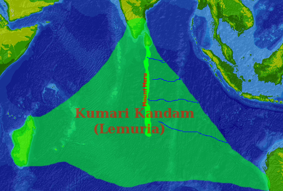
- Lemuria was borne from a confusion over the finding of lemur and related primate fossils in Madagascar and India, but not in mainland Africa. They were correct in their proposal that Madagascar and India had once been part of a larger continent (it was Pangaea), but wrong that this continent must have diseappeared Atlantis-like into the Indian Ocean. Interestingly, the idea of Lemuria captured the imaginations of Tamil writers, who coincidentally had their own mythological idea of the sunken landmass Kumari Kandam. Tamil revivalists, wishing to differentiate themselves from Hindi world, seized these ideas and turned into a pseudo-scientific theory.
- Finally, Mu, a kind of Pacific Atlantis was proposed by Augustus le Plongeon whose overactive imagination held that the Egyptians and the Maya, both seeming to build pyramids, must have originated as refugees from the shattering of their home continent. The idea, while thoroughly debunked, can still be found on the likes of Spirit Science.
")