Flash's Terra map

Flash1

Prince
Joined
Feb 5, 2003
Messages
350
Location
Carbondale, Il
Hello all,
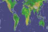
I'm making a terra sized Earth map. It will be 128 x 80. I found a new mercator Topographical map I like and scanned and cropped it into 4 pieces.

I have a few questions?
How do I find plot 0,0?
Any ideas for features I should consider?
How many civs?

I attached a preview map of piece 1a of the eastern Hemisphere

 
The above map makes a 58 x 70 section.
And it covers roughly 60degree by 60degrees.
 
part 2 of map. it is section 2a
 
I like this, but I have some issues. I realize memory equals limitations but to get a real Earth like playable game there are details of the land that need to be there. The problem is that those details can't be there in a 256*256 field. That literially would leave no vastness of the oceans. I've been able to expand the map a little beyond the 256*256 but not much. I have no ideas currently for a work around but I am looking it some possibilities. Some answers though are provided for extending the time table and changing resource\tech percentages. But as to the actual map. I am thinking maybe a America's and a Asia map. Then contecting the two on the ends. Kinda like those civ mods of old that used a space map and earth map. I might be off a bit here but something like this could posibily be used. Or just find a method to expand the 256*256 to something like 600*400. Which might be possible if you disable some graphic stuff. I'm going to try that one right now.
 
Right now this project is for a Terra sized map of 128x80. There is a mod by Low that will make a 160 x 80 map but there are memory issues that the game has or I would make this map 160 x 80. I would prefer something about 256 x 128.
 
two seperate maps would be great too (Old World/New World).
 
Okay here are the last two sections. The cover 60 degrees north and upward. they have been compressed.

Map 1b is 58 x 10
Map 2b is 70 x 10
 
I saw this on one of these forums but couldn't locate the actual link. So here's a FTP link from my IE history

ftp://ftp.ngdc.noaa.gov/GLOBE_DEM/pictures/

Take a look at the file

ftp://ftp.ngdc.noaa.gov/GLOBE_DEM/pictures/GLOBALeb3colshade.jpg

I've already taken the image and produced a bmp file that is along the lines of the BMPC186 BMP to WBS for the portion related to Height. The BMP is almsost 80 megs. Ouch... But I am getting fast at editing it. Just a thought for those out there. I figure it's the best detailed and can be scaled down to even the largest map or smallest. Oh and there's no text to deal with on the image. Enjoy

Tbear2520
 
tbear,
you rock.

I'd seen the second map before and it was redone for CTP2. I always wondered what the original map looked like. I can't thank you enough. If i do a 256 x 128 map I'll use this one.
 
Change of plans. Thanks to the Atlas Project. I'm doing a 180 x 130 map. If this one will run, then I'll consider as my pet project the gigantic 256 x 128 map.

The idea is to bring each 10 degrees of latitude from 60 degrees North latitude to 60 degrees South latitude to equal 10 plots.

Each 20 degrees of logitude equals 10 plots
 
Great initiative, and I like your approach to compress the polar regions.

Dunno if you have it, but an application like photoshop can very easily put a 180x130 raster on any image, might be useful for classification or to get an impression what it'll be like.

Of course, I'm glad Atlas could help :)

(edit: I gave it a quick try and I must say Africa comes out pretty huge... See attachment
this is resized to 180x120 at 1 deg latitude/2 deg longitude per pixel)
 

Attachments

  • world2.jpg
    world2.jpg
    26.8 KB · Views: 1,309
Thanxx junuxx,
That looks like part of a map I found edited for CTP2.
I resized and cropped it to 225 x 110.
 
*Reserved*
 
Well here's the altered Earth with Height. I could add more hills and mountains in places like Alaska. But it's taken alot to get it to where it is now even.


It's a screen shot in a openoffice - MS-Word 2000 doc file.

It's 4 megs as a jpg. Ouch

TBear2520
 

Attachments

@tbear:

I think the Alps, the Pyrenees, the Balkans and lots of the Andes are missing..?
Saving as a gif should help to reduce size btw.
 
Junuxx, thanks for the tip on the gif. I'll try that. Currently I'm at work and won't have time for a couple of days.

Yea I will have to go back and adjust some hills and mountains a little bit. The color's didn't quite seperate or show them much. I spent all day :crazyeye: trying to get rid of little color spots throughout the map. In the end hopefully it will all be worth it. ;)

Got to go for now.

TBear2520
 
tbear2520 said:
Well here's the altered Earth with Height. I could add more hills and mountains in places like Alaska. But it's taken alot to get it to where it is now even.


It's a screen shot in a openoffice - MS-Word 2000 doc file.

It's 4 megs as a jpg. Ouch

TBear2520
One Question on SUPER Map, a Small land on top so we can do polar trips from US to euope?
 
panza105 said:
One Question on SUPER Map, a Small land on top so we can do polar trips from US to euope?

Yea I've been thinking that. I really don't get much play time though. But maybe Saturday I will tackle it some more. I was thinking maybe some Ice along the top but I haven't worked just the right idea in my head yet.

Tbear2520
 
Are you guys true explorers or just Exkimos? Just joking.

Interesting concept though.
 
Back
Top Bottom