Exsanguination
No longer here
How to Make Accurate Maps by Exsanguination
Programs used:
-Civ3Edit.exe
-Abode Photoshop 6.0
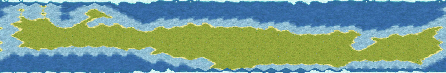
We are going to recreate this map (on a 60x20 map for simplicity). The actual picture's dimensions are 600x200.
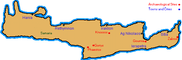
1) Plot out and find the coordinates of key points on the map:

Find the pixel coordinates for each point (I generally find 4-5 coordinates, map them in civ3edit, then go back). To do this in PS6: 1) Turn on "rulers" (ctrl+r); 2) "Show Info" (click the "info" tab in the navigator window; or go window=>show info); 3) move your cursor (make sure it is the pointer) over the decided points, and look in the "info" window for the (x,y) coordinates; 4) write them down!
Here are the first 6 on this map(enlarged, also seen as marked with a black dot on above map):
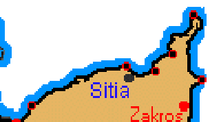
(596,110)
(591, 72)
(578, 94)
(569, 104)
(551, 102)
(497, 125)
3) Now, VERY IMPORTANT: Notice that the above coordinates won't fit on a 60x20 map. how will they? Reduce the (x,y) values ("numbers" for you non-math people) by the suitable factor: in this case, 10.
Where did I get that number? Notice the original map is 600x200, and the game map is going to be 60x20. What is the "magnitude" of change (I can't really explain this well, I'll try to if you don't understand)? - 10.
So now, the coordinates become:
(59.6,11.0)
(59.1, 7.2)
(57.8, 9.4)
(56.9, 10.4)
(55.1, 10.2)
(49.7, 12.5)
And of course, you can't put decimals on the civ3edit map. Solution? ROUND. So now, we change the coordinates again! They become:
(60, 11)* => (59, 11)
(59,7)
(58, 9)* => (58, 8)
(57, 10)* => (57, 9)
(55, 10)* => (55, 9)
(50, 13)* => (50, 12)
*We didn't have much luck with this map. Notice that the coordinates become both an odd and even number - this can't be done using the isometric Civ3 display. The only way to get around this is to look at map and decide whether or not to move either coordinate one up, or down (or across). This is one of the inaccuracies of this method of map making.
3) Plot the points in civ3edit! (tip: turn on "grid coordinates" in civ3edit. It will be kind of hard without it on).
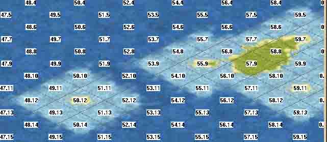
4) Connect the dots. Check your map for the details. If you are real picky, you can plot out even more points in between those already plotted.
5) Do this all your selected points. You would get a map of Crete looking like this:
6) You're done!
***Note: You probably notice that this map is actually pretty bad (not accurate). This is due to the extraeme size constraints - I only made this for an example. To see a better example of this method, see this thread, where I made a map for the Alexander the Great Scenario. This is a very accurate map - and, as you can tell, it is much larger.
If you have any questions, comments, or concerns, feel free to post them!
Programs used:
-Civ3Edit.exe
-Abode Photoshop 6.0
We are going to recreate this map (on a 60x20 map for simplicity). The actual picture's dimensions are 600x200.
1) Plot out and find the coordinates of key points on the map:
Find the pixel coordinates for each point (I generally find 4-5 coordinates, map them in civ3edit, then go back). To do this in PS6: 1) Turn on "rulers" (ctrl+r); 2) "Show Info" (click the "info" tab in the navigator window; or go window=>show info); 3) move your cursor (make sure it is the pointer) over the decided points, and look in the "info" window for the (x,y) coordinates; 4) write them down!
Here are the first 6 on this map(enlarged, also seen as marked with a black dot on above map):
(596,110)
(591, 72)
(578, 94)
(569, 104)
(551, 102)
(497, 125)
3) Now, VERY IMPORTANT: Notice that the above coordinates won't fit on a 60x20 map. how will they? Reduce the (x,y) values ("numbers" for you non-math people) by the suitable factor: in this case, 10.
Where did I get that number? Notice the original map is 600x200, and the game map is going to be 60x20. What is the "magnitude" of change (I can't really explain this well, I'll try to if you don't understand)? - 10.
So now, the coordinates become:
(59.6,11.0)
(59.1, 7.2)
(57.8, 9.4)
(56.9, 10.4)
(55.1, 10.2)
(49.7, 12.5)
And of course, you can't put decimals on the civ3edit map. Solution? ROUND. So now, we change the coordinates again! They become:
(60, 11)* => (59, 11)
(59,7)
(58, 9)* => (58, 8)
(57, 10)* => (57, 9)
(55, 10)* => (55, 9)
(50, 13)* => (50, 12)
*We didn't have much luck with this map. Notice that the coordinates become both an odd and even number - this can't be done using the isometric Civ3 display. The only way to get around this is to look at map and decide whether or not to move either coordinate one up, or down (or across). This is one of the inaccuracies of this method of map making.
3) Plot the points in civ3edit! (tip: turn on "grid coordinates" in civ3edit. It will be kind of hard without it on).
4) Connect the dots. Check your map for the details. If you are real picky, you can plot out even more points in between those already plotted.
5) Do this all your selected points. You would get a map of Crete looking like this:
6) You're done!
***Note: You probably notice that this map is actually pretty bad (not accurate). This is due to the extraeme size constraints - I only made this for an example. To see a better example of this method, see this thread, where I made a map for the Alexander the Great Scenario. This is a very accurate map - and, as you can tell, it is much larger.
If you have any questions, comments, or concerns, feel free to post them!
 .
.")

") .
. The whole point of this tutorial is to make accurate maps! Would you care to elaborate on what you mean?

 I am simply afraid that when I post my finished map people will start complaining that Italy look more like a penny loafer and not a boot, especially those that love the Roman Civ:die: