darkpanda
Dark Prince
- Joined
- Oct 28, 2007
- Messages
- 845
Navigating through the CIV code that renders the map reminded me of an old post where I talked about a particular map rendering glitch:
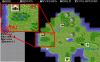
I was talking about the fact that, although contiguous plains, mountains, forest or even desert benefit from graphics that show them as a single mass, it was not the same for jungle and swamp (and tundra and arctic too, btw), which are still using the single square graphics even when there are multiple contiguous squares.
Well, I found out that this behaviour is coded with an explicit limit within the CIV code, although the reason remains a mystery... It could be due to a limitation in the graphics capabilities or memory...
Anyway, it can be fixed with a simple mod:
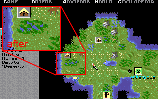
You can see the difference in the pictures below:

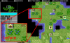
- for some reason, Civ does not use this mechanism for all terrain types; for example arctic and jungle always use the single tile graphics, even when there are adjacent arctic/jungle tiles:

I was talking about the fact that, although contiguous plains, mountains, forest or even desert benefit from graphics that show them as a single mass, it was not the same for jungle and swamp (and tundra and arctic too, btw), which are still using the single square graphics even when there are multiple contiguous squares.
Well, I found out that this behaviour is coded with an explicit limit within the CIV code, although the reason remains a mystery... It could be due to a limitation in the graphics capabilities or memory...
Anyway, it can be fixed with a simple mod:
Code:
offsets:
   EN 47401: 0x30D0E
   EN 47403: 0x30525
   EN 47404: 0x30525
   EN 47405: 0x30D25
   EN 47501: 0x30D0E
   FR 47405: 0x32134

original bytes: 83 7E FC [COLOR="Red"]06[/COLOR]
 patched bytes: 83 7E FC [B][COLOR="Blue"]0A[/COLOR][/B]
You can see the difference in the pictures below: