Northwest Europe (Huge, 150x110)

Craig_Sutter

Deity
Joined
Aug 13, 2002
Messages
2,773
Location
Calgary, Canada
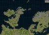
I've created a map of NW Europe including British Isles, Northern France and Germany, Denmark and a large part of Scandinavia. Also the Faroes and Shetlands.

Jungle represents Marshland.

The map is skewed about 40 degrees from true north to fit in the areas I wanted.

This is a work in progress, eventually to be a mod. Please let me know of any map errors. I'm uncertain about which areas to make grassland, and would love anyone to point me to climate/and or soil/vegetation maps of these areas to determine thinks like grassland/plains, and what should be tundra.

Resources are randomly placed. Feel free to randomize them on your own.

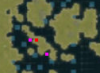
Versions: 1.00 - Added Goody Huts (67 views)
 

Attachments

  • North West Europe Screenshot.JPG
    North West Europe Screenshot.JPG
    150.1 KB · Views: 4,304
  • Northwest Europe.zip
    Northwest Europe.zip
    61.1 KB · Views: 1,566
Hi, the map is great! very realistic~

but the starting locations are a bit weird.
was playing as Chinese and started at the western edge with all hills and trees, isolated by mountains, also french and incas were 6 tiles away, with similar landscapes :/
 
Checked my WBS file... no starting locations are set. Neither in the individual civilizations player settings, nor assigned as locations in specific plots.

I guess you just got a bad random draw.

Let me know if the terrain is too strange. I tried to be as accurate as possible based upon about 50 different maps. But still, I'm certain there are some oddities.

As well, I'm a little unhappy with all the plains-forested-hills in Scandanavia... I wish to make many more tundra hills there, and match some grassland to hills in places where cities have developed. I'll submit new versions after I've thought on things more, and gathered more info.

Also working on a Anglo-Saxon/Viking scenario. Still mulling over ideas - likely be from about 450 AD to 1150 AD or so. Current civs I'm considering are Vikings - Denmark/Sweden/Norway/Trondelag; Anglo-Saxons - Saxons/ Angles/Jutes/Northumbrian Angles, Franks and Normans, Germans (Saxons), Celts - Welsh/Irish/Dumnonia/Dalriada Scots/Picts, and non-player Roman-Celts (comprise of British Romans and Gualish Romans). Religions: Druidic, Nordic Pantheism, Arian Christian, Christian, Celtic Christian and Roman Catholicism. The Christian sects are more differentiated by closeness to Rome and the Pope than by religious differences.

One idea for Nordic Pantheism is to have Berserkers replace missionaries that don't spread the religion, but are limited in number, and are combat units, rather.

Anyhow, I'm still in the planning stages. And have many other ideas I want to consider.

Next stage, though, is creating civilizations, and adding cities to the map.
 
Wow this is a great map!:clap:
 
Craig_Sutter said:
Let me know if the terrain is too strange. I tried to be as accurate as possible based upon about 50 different maps. But still, I'm certain there are some oddities.

As well, I'm a little unhappy with all the plains-forested-hills in Scandanavia... I wish to make many more tundra hills there, and match some grassland to hills in places where cities have developed. I'll submit new versions after I've thought on things more, and gathered more info.
.

Well, living in Sweden myself, I can let you know there's no tundra around here. It all thaws from one year to the next. Sweden was also the prime source for timber in europe for a very long time, albeit this started well after your projected period of play. Just FYI. :)
 
Yeah, I realize there likely isn't a lot of tundra in Sweden... but what is the terrain in the highland areas? There really aren't enough terrain types to reflect reality, I suppose, but the plain/hills covered by timber that comprises much of my map in the area of Sweden just seems wrong. I'm inclined to think the terrain might be like the Canadian shield in nature, a lot of rock, and so, in such case, I think that Tundra may be a better reflection of such than Plain.

And I don't get me wrong, but I want Swedish beavers...:) . Northern forests seem proper territory for these, however, tundra forests, I believe, are the only kind that provide for such resources. Hence, I'm still reflecting on how to adjust the terrain.
 
If anyone wishes to make a scenario, by the way, I'm very willing to do city placement... it's relatively easy, and I will be doing it for my own scenario, eventually. I assure accuracy.

A viking scenario is a good idea. I've been leaning towards a larger time period (500-1100 AD), but I'll gladly scavange anyone else's efforts for source material that would fit into my scenario.
 
Just a note, below the islands of Funen and Zealand in Denmark there is a large island, IMO that should be split into smaller islands to fit with reality.
 
You're correct of course. It's unfortunate that the game does not allow one to depict narrow courses of water correctly, such as straits. The squares of the islands in question are linked by the corners, and are meant to be seperate islands, but I can't show that effect properly. There are several places where I had to chose between removing islands completely, and putting open water where there is, in reality, land, or on the other hand, keeping the islands in question even though it created unrealistic connections between a string of islands. Sometimes, due to scale, islands had to be amalgamated, or even joined to very close landmasses. These consessions to the nature of the mapmaking process make for a map that differs from reality in any number of ways. This is most notable in the Danish islands, as you pointed out, and in the many islands west of Scotland. In some cases, I chose to one option, in others, the other.

In the next version of the map, I'll look at the specific instance you cite, and see if I can juggle the islands in the area, or remove some, to reflect reality in a different way... my thoughts are that I may remove one of the island portions to the far west of the landmass in question (the middle one), but leave the rest linked as the two large islands in the east of the chain, on my maps at least, appear to be very very close to each other, close enough to be considered almost one for the purposes of the scale of this game. In future, when I do a scenario, the city of Nykoping will be between those two, anyhow, and for all intents and purposes, will create a strait between the islands that can be transversed by ships of the owner of the city.

Are you from the area in question? What are your thoughts? I want the best and most accurate map possible, so any guidance to helpful maps or info would be appreciated.
 
This really is an amazing map. I am a sucker for any kind of European map with a lot of space in the British Isles and Northern Europe. I love to re-enact the civilizations there.
 
Craig_Sutter said:
You're correct of course. It's unfortunate that the game does not allow one to depict narrow courses of water correctly, such as straits. The squares of the islands in question are linked by the corners, and are meant to be seperate islands, but I can't show that effect properly. There are several places where I had to chose between removing islands completely, and putting open water where there is, in reality, land, or on the other hand, keeping the islands in question even though it created unrealistic connections between a string of islands. Sometimes, due to scale, islands had to be amalgamated, or even joined to very close landmasses. These consessions to the nature of the mapmaking process make for a map that differs from reality in any number of ways. This is most notable in the Danish islands, as you pointed out, and in the many islands west of Scotland. In some cases, I chose to one option, in others, the other.

In the next version of the map, I'll look at the specific instance you cite, and see if I can juggle the islands in the area, or remove some, to reflect reality in a different way... my thoughts are that I may remove one of the island portions to the far west of the landmass in question (the middle one), but leave the rest linked as the two large islands in the east of the chain, on my maps at least, appear to be very very close to each other, close enough to be considered almost one for the purposes of the scale of this game. In future, when I do a scenario, the city of Nykoping will be between those two, anyhow, and for all intents and purposes, will create a strait between the islands that can be transversed by ships of the owner of the city.

Are you from the area in question? What are your thoughts? I want the best and most accurate map possible, so any guidance to helpful maps or info would be appreciated.

I am from Denmark, so I know a bit about it. I forgot to mention, it's a great map you've created.
There is a lot of water in the top of the map to make room for the Shetland Islands, you could squeeze that a bit to make room for some more land in the southern part of the map (for example, I think Berlin is just south of the southern edge of the map).

About the area in Denmark, you could remove the square marked with red in the first attached image, and possibly also add some land in the squares marked with pink. That way, the landmass to the left can represent the islands of Ærø and Langeland, and the land to the right will be Lolland, Falster and Møn. (You can see that on the second image.)
 

Attachments

  • North West Europe Screenshot.PNG
    North West Europe Screenshot.PNG
    25.7 KB · Views: 282
  • danmark.JPG
    danmark.JPG
    51.2 KB · Views: 207
Thank-you. I'll make those adjustments as soon and release a new map in the next couple of days. Appreciate the input.

I realise Berlin is just slightly south. My focus was on other areas in view of scenarios I'm thinking of doing... however, if there is enough demand I could expand the map size easily enough, or as you say, remove the Shetlands. I was more focused on a viking scenario however, so the Shetlands are more relevant to that. I was, as well, looking at an expansion northward to Iceland, though that would make the map 150x180, much expanded for little gain in land, and possibily unplayable. I'm satisfied with the dimensions for now, though.

Anyhow, thanks for the advice.
 
Well, given the use the AI is making of the small islands you could surely skip the Shetlands and make the map smaller. As far as I know only humans are able to understand the Shetlands strategical value, so it would be an unfair advantage over the (already stupid enough) AI.
 
I'm currently working on an identical map, but 105x77. If it doesn't seem to be playable due to being too large, then I'll drop the Shetlands. If I can ever get Ktswoll's civ map editor working again (it stopped working on my machine for some reason), cutting part of the map is rather easily done with that program.

I'll post the new map as soon as its playable.
 
Back
Top Bottom