1204 states

Kyriakos

Creator
Joined
Oct 15, 2003
Messages
78,218
Location
The Dream
Anyone have a map, or other info, about the states that were formed in the Byzantine Empire lands, and surrounding areas, in 1204?

I decided to put the other scen on hold, since it is too big of a task, and will instead work on this smaller-scale scenario :)

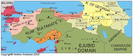
Here is the map of the area i am interested in:

minimap.png


The states i currently have are:

Greek

Empire of Nicaea
Empire of Trebizond
Despotate of Epirus
Principality of Theodoros

Latin

Empire of Constantinople
Kingdom of Thessalonike
Dutchy of Athens
Principality of Achaia
Palatinate of Cephalonia
Dutchy of Negroponte
Venice

Crusader states

Principality of Antioch
County of Tripoli
Kingdom of Cyprus

Other chirstian orthodox

Kingdom of Bulgaria
Kingdom of Serbia
Kingdom of Cilicia
Kingdom of Georgia
Great Wallachia

Muslim

Sultanate of Rum
Sultanate of Khelat
Mameluke domain

The thread for the scenario development is http://forums.civfanatics.com/showthread.php?t=365729
 
I found this map of 1204 with a quick Google search:

4cde.jpg


It features some cities, so it might be helpful.
 
Thank you for the map :)

Anyone know who owns Rhodes and that purple part of the Peloponnesos?

Also i would like to fragment the Rum sultanate, since i have a few civs left to place. Any map of them would be very usefull :)
 
Rhodes and the city of Monemvasia/Malvasia were acquired by Venice during the Fourth Crusade.
 
You're right, Monemvasia was only under Latin from 1249-1263. But Modon is too far on the western coast ...
 
Cephalonia was simply a vassal of Naples at this time. Considering you have a wee bit of the Boot on the map, it might be better just to make it all the Kingdom of Naples.
 
Monemvasia was just run by its own garrison. It simply held out a long time against the Latins after the fourth crusade.

Rhodes was its own independent Despotate under the despot Leo Gavallas.
 
Adrianople, as you can see from the map, is within the territory of the Latin Empire at Constantinople. The independent bit to the west of Adrianople is the [wiki]Duchy of Philippopolis[/wiki].
 
What are that Principality of Theodoros and that Sultanate of Khelat? I've never heard of them and they're not on the map.

I also can't see what the Mamelukes are doing on your list.

Rulers in 1204:

Nicaea: Theodore I Lascaris
Trebizond: Alexius I
Epirus: Michael I Comnenus Ducas
Rhodes: Leo Gavallas

Latin Empire: Baldwin I
Kingdom of Thessalonica: Boniface of Montferrat
Duchy of Athens: Otto de la Roche
Principality of Achaia: William of Champlitte
Palatinate of Cephalonia: Mateo I Orsini (as part of Sicily)
Lordship of Negroponte: Jacques d'Avesnes (but after one year, the lordship was split in three)
Venice: Enrico Dandalo (until 1205) or Pietro Ziani (after 1205)

Antioch and Tripoli: Bohemond IV
Cyprus: Amalric of Lusignan (until 1205) or Hugh I (after 1205)

Bulgaria: Kaloyan the Romanslayer
Serbia: Stefan II Nemanjic
Cilicia: Leo I
Georgia: Queen Tamar
Great Wallachia: Part of Epirus

Rum: Kilij Arslan III (until 1205) or Giyath al-Din Kaykhusraw I (after 1205)
 
Thanks a lot :)

Theodoros is the successor state in the southern tip of the crimean peninsula.
The khelat sultanate was in a map i found of 1204, it is a part of the eastern asia minor, eastern than the rum seljuks.

What should be there instead of Mamelukes?

Also, do you have any knowledge of splits in the rum seljuks? Since i have 6 more civ spots i can fill :)
 
The Ayyubids are what you should have instead of the Mamelukes.

I don't think that there's any room on your map for anything east of Rum. I can't find a "Khelat Sultanate" on any of my maps.

You could put in [wiki]Mengucek[/wiki] (under Fahrettin Behramşah).

However, apart from Mengucek, the Rum Seljuks were not actually split at all in 1204, and they were actually pretty powerful. In 1246 it was split for the first, and Wikipedia has a good account of this, but it might be better just to make it unplayable or give it a government with lots of corruption. Plenty of excellent scenarios don't have 31 civs.
 
Look at this.

I can't find Khalat anywhere else and so, as it was a protectorate of Georgia, I'd say it's probably easiest just to include it within Georgia.
 
Another question is capitals.

Aside for the obvious ones (the ones giving their name to the respected nation) do you know the others?

I am particularly interested in:

Despotate of Epirus (Arta?)
Rum seljuks (i guess Iconion)
Kingdom of Cilicia
Kingdom of Georgia (the map only has a part of it)
Rhodes (there is room for two cities there, would it be Lindos?)
Venice (in this map, perhaps Chania?)
Kingdom of Bulgaria
Kingdom of Serbia
Ayyubids (again the map has a small part of their domain)
Principality of Achaia (Patrae?)
Cyprus
Great Wallachia (this isnt the wallach state in Greece, in maps it doesnt exist at 1204, it is the wallach region in the northernmost part of the map.)
 
In the same order as your list,

Arta,
Iconion,
Sis,
Tblisi (but Tskhumi perhaps on your map),
Rhodos,
Candia,
Tarnovo,
Stari Ras,
Aleppo or Damascus,
Andravida,
Nicosia,
is there really room? I'd fill it with barbarians; the Vlachs of the time were semi-nomadic if not entirely nomadic.


Another thing: Argos and Nauplia and Corinth were an independent Greek state until 1212 under Leo Sgouros with the capital at Nauplia.
 
Thank you :)

And what name would Argos-Nauplion-Corinth have as a state?

Btw i made the map, years ago. Currently i am working on the cities, building and terrain gfx :)

poleis.png
 
Back
Top Bottom