lindsay40k
Emperor
Edit: check my sig for the latest version. Bigger than my first map, more balanced and better looking. Ya ta!
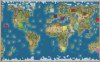
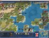
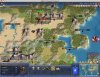
This is my first map upload, I hope people enjoy it. Download it here, unpack it, and pop it into the PublicMaps folder in your Civilization IV Beyond the Sword directory (in Documents) to play the Scenario.
I wasn't happy with a number of things about the Earth 18 Civs map that comes with BTS. The Inca seem to always gets trapped, the Aztec conquer the USA before the Old and New Worlds meet, and Western Europe is very densely populated.
I started with a list of civs I and my usual gaming partners like to play; Japan, Carthage, France, Mali, Persia, Inca, England, Rome, Russia, Egypt, Zulu.
I added the Khmer, Mongols, Aztecs, Maya and Native America (renamed to the Sioux) to fill out space and keep things interesting.
I then added a trio of civs with mixed-up leaders & colours, and renamed them to various indigenous peoples who inhabit areas left empty by the list of civs available. (I'm sure there are many mods that would have enabled more seamless representation of these nations, however my goal was to stay strictly mod-free for the same of simplicity.)
The Mali became the Narinjerri of Australia, who seemed suited to an early unit. They were given Fishing and Hunting. Mansu Musa seemed a good match for the renowned inventor and preacher David Unaipon, so no need to change him. I chose the spelling of their name most accessible to dyslexic players.
The seaworthy Vikings became the Polynesians, who are masters of Hunting and Fishing and whose wardancers might have become Berzerkers had their economy developed differently") The land-grabbing Zara Yaqob quickly unites the Pacific islands as Kamehameha I.
The land-grabbing Zara Yaqob quickly unites the Pacific islands as Kamehameha I.
The enlightened Gandhi stands in as Tagak Curley, the Inuit civil rights leader. His people are herein virtually identical to Native America, except that they prefer Hunting to Agriculture.
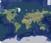
The name New Terra didn't seem to be taken except by a mapscript, so I presumed it would be OK to use it for a mapname. Let me know if I've stepped on your toes and I'll change it")
Various concepts informed the map:
- The New World shall be the only source of Corn and have many Calendar resources, yet lack Iron, Horse or Wheat. No Crossbows, Pikes or Knights shall await colonists and conquistadors eager for new food sources - but a prescient Sitting Bull may prioritise Gunpowder and "unite" the indigenous peoples.
- African civs and the Khmer have access to two Ivory; one to keep, one to trade. Persia can grab one in India.
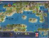
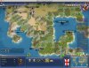
- Ocean-hopping by popping borders to reach another landmass three tiles away is a common feature. The Polynesians island-hop with ease, thanks to CRE (, and Australia and whilst Old World civilizations who settle the tips of the land and learn the seas may make contact with the Americas, actual trade and conflict is impossible without oceanfaring vessels.
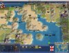
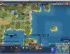
- Resources all placed where a real-world source exists, with a balance between ancient and modern centres of production and a mind for on game balance.
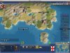
- The geography aims not to give civs obvious great advantages if it's avoidable. Where civs are vulnerable to early rushes, hills and rivers are used to make Capitals a tough nut to crack.
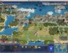
- The map is crafted with aesthetics in mind, and with plenty of landmark tags to fill it with flavour and give players pride in their national geographical landmarks - and taunt rivals from whom they wrest control of natural wonders such as the Bering Strait, Mount Sinai, or the Devil's Mountain. (Teachers! My map has - admittedly specious at best - educational value!)
I look forward to any feedback that might help make the map more entertaining and balanced, and at some point making larger versions that follow the same design philosophy.
Credits:
Earth 18 Civs map for the basic forms of British Isles, Ireland and Japan.
Earth2 mapscript for doodling the basic shapes of continents.
WellMad for tech help and playtesting.
AmyColt for inventing Polynesia, persuading me to include England and France, and playtesting.
This is my first map upload, I hope people enjoy it. Download it here, unpack it, and pop it into the PublicMaps folder in your Civilization IV Beyond the Sword directory (in Documents) to play the Scenario.
I wasn't happy with a number of things about the Earth 18 Civs map that comes with BTS. The Inca seem to always gets trapped, the Aztec conquer the USA before the Old and New Worlds meet, and Western Europe is very densely populated.
I started with a list of civs I and my usual gaming partners like to play; Japan, Carthage, France, Mali, Persia, Inca, England, Rome, Russia, Egypt, Zulu.
I added the Khmer, Mongols, Aztecs, Maya and Native America (renamed to the Sioux) to fill out space and keep things interesting.
I then added a trio of civs with mixed-up leaders & colours, and renamed them to various indigenous peoples who inhabit areas left empty by the list of civs available. (I'm sure there are many mods that would have enabled more seamless representation of these nations, however my goal was to stay strictly mod-free for the same of simplicity.)
The Mali became the Narinjerri of Australia, who seemed suited to an early unit. They were given Fishing and Hunting. Mansu Musa seemed a good match for the renowned inventor and preacher David Unaipon, so no need to change him. I chose the spelling of their name most accessible to dyslexic players.
The seaworthy Vikings became the Polynesians, who are masters of Hunting and Fishing and whose wardancers might have become Berzerkers had their economy developed differently
The land-grabbing Zara Yaqob quickly unites the Pacific islands as Kamehameha I.The enlightened Gandhi stands in as Tagak Curley, the Inuit civil rights leader. His people are herein virtually identical to Native America, except that they prefer Hunting to Agriculture.
The name New Terra didn't seem to be taken except by a mapscript, so I presumed it would be OK to use it for a mapname. Let me know if I've stepped on your toes and I'll change it
Various concepts informed the map:
- The New World shall be the only source of Corn and have many Calendar resources, yet lack Iron, Horse or Wheat. No Crossbows, Pikes or Knights shall await colonists and conquistadors eager for new food sources - but a prescient Sitting Bull may prioritise Gunpowder and "unite" the indigenous peoples.
- African civs and the Khmer have access to two Ivory; one to keep, one to trade. Persia can grab one in India.
- Ocean-hopping by popping borders to reach another landmass three tiles away is a common feature. The Polynesians island-hop with ease, thanks to CRE (, and Australia and whilst Old World civilizations who settle the tips of the land and learn the seas may make contact with the Americas, actual trade and conflict is impossible without oceanfaring vessels.
- Resources all placed where a real-world source exists, with a balance between ancient and modern centres of production and a mind for on game balance.
- The geography aims not to give civs obvious great advantages if it's avoidable. Where civs are vulnerable to early rushes, hills and rivers are used to make Capitals a tough nut to crack.
- The map is crafted with aesthetics in mind, and with plenty of landmark tags to fill it with flavour and give players pride in their national geographical landmarks - and taunt rivals from whom they wrest control of natural wonders such as the Bering Strait, Mount Sinai, or the Devil's Mountain. (Teachers! My map has - admittedly specious at best - educational value!)
I look forward to any feedback that might help make the map more entertaining and balanced, and at some point making larger versions that follow the same design philosophy.
Credits:
Earth 18 Civs map for the basic forms of British Isles, Ireland and Japan.
Earth2 mapscript for doodling the basic shapes of continents.
WellMad for tech help and playtesting.
AmyColt for inventing Polynesia, persuading me to include England and France, and playtesting.