albie_123
Modding In Secret
Played with the new patch.
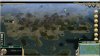
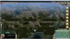
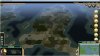
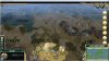
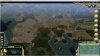
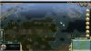
Still far too many oases on deserts, in fact I've noticed no change. Wheat is now spawning all over deserts as well. Overall, deserts on this mapscript are a joke. They're better than any other terrain to build a city on.


(Two different maps, both deserts found within a few turns.)
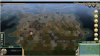
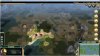
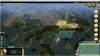
There has also been no change to the band of jungle and marshes at the equator on every continent, every single time I play the mapscript.
On an unrelated note, ruins are NOT being got by the AI. I sometimes find plenty one tile or two tiles away from an AI's borders at turn 100.
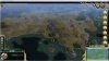
To be honest, so far my experience with this mapscript has been pretty average, and I'll be playing with Continents Plus until the desert and jungle issues get sorted.
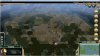
Still far too many oases on deserts, in fact I've noticed no change. Wheat is now spawning all over deserts as well. Overall, deserts on this mapscript are a joke. They're better than any other terrain to build a city on.
(Two different maps, both deserts found within a few turns.)
There has also been no change to the band of jungle and marshes at the equator on every continent, every single time I play the mapscript.
On an unrelated note, ruins are NOT being got by the AI. I sometimes find plenty one tile or two tiles away from an AI's borders at turn 100.
To be honest, so far my experience with this mapscript has been pretty average, and I'll be playing with Continents Plus until the desert and jungle issues get sorted.

")

") They're also not so rare that you can't get lucky with them - I saw quite a good desert that had two quite close to each other and some luxuries.
They're also not so rare that you can't get lucky with them - I saw quite a good desert that had two quite close to each other and some luxuries. Thal, strong suggestion to implement this in the next patch.
 ), it's a really great mapscript, and easily my new favourite!
 food and 1
  gold unimproved + fresh water bonus to all adjacent is a powerful tile indeed.