Compiling the terrain "can" be "simple". Depends on how well they blend to begin with. Also depends on how comfortable you are using layers, selecting by color, & indexing.
1) create a file in RGB mode,
not indexed mode, with the terrains as layers.
2) select and remove the terrain you don't want from the top layer, so that the terrain you do want shows on the layer below.
For example, if you want the grassland from one file but coast from another, create an RGB mode file with the xggc.pcx from both terrain sets as layers. Let's say the grass you want is on the top layer, with the coast below. On the top layer select everything that is coast. Cut it. The coast from the other layer (the coast you want) should now show through.
It doesn't matter which terrain is on top - it's just a matter of cutting away what you don't want, so that the other shows through. You must repeat this process for each pcx. In the files that have 3 terrains - such as the xdgp - you can use terrain from 3 different sets. If you want it to blend just make sure you always use the one terrain from the same set. For example, all desert in all files should come from one original set.
3) Merge layers or flatten the image. Then index. Save the image as a pcx with the proper name.
- - - - -
Done. Simple, right? Except for two problems that happen at step 3.
The
first problem & simplest to solve is when the colors of a terrain don't quite match between your final pcx files. For example, the grassland in the xggc may not look quite the same as the grass in the xpgc, making it not look weird on the map especially where tiles from each are next to each other. This problem happens because during the indexing process a slightly different set of colors were selected for each file.
I believe it was Vuldacon who suggested a relatively simple solution. Make a master file with all the relevant files next to each other on a single layer. Index it. Then use that palette for the individual pcx files. Several different ways to do that last step. you'll have to figure out which way is easiest for you.
The
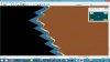
second problem is a bit trickier to solve. When you combine terrains the transitions may be too abrupt. The transition between grass & plains, for example, might look too much like a bordering edge rather than them blending into each other.
The solution here is to patiently use a blending filter. If you look at the firaxis terrain or Ares' beta you will notice some greens from the grass & browns from the desert scattered into the other terrain. There are several filters (such as noise>spread) that will work. Select only the transition area you want to blend, then apply the filter. You could do this in RGB mode, but I've found it simpler to work with the indexed file since I can see the final result right away. It may take several attempts to get the look you want, and you may need to adjust some parameters at each place you want to blend, so this step can be very time consuming.
- - - - -
Balthasar & Ares are both quite accomplished. Both have constructed terrains combining elements from other sets. Balthasar has produced several terrain sets in the time that Ares' remains officially a beta even though it looks finished to most of us (8+ years).
Depending on how comfortable you are with the tools and techniques, and how much you must get into the two major problems, the process can be simple or complex, easy or difficult, so there's no way to predict how long it will take "the average person". Depends on how closely the original sets match, what you need to do to combine them, and how satisfied you are with the results.