You are using an out of date browser. It may not display this or other websites correctly.
You should upgrade or use an alternative browser.
You should upgrade or use an alternative browser.
Hurricane Katrina becomes Category 4
- Thread starter Ginger_Ale
- Start date
SeleucusNicator
Diadoch
So has it made the turn towards NO officially?
Quasar1011
King of Sylvania
Okay, the 5 p.m. bulletins from the hurricane center are coming in now...
---------------------------------------------------------
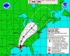
HURRICANE KATRINA DISCUSSION NUMBER 24
NWS TPC/NATIONAL HURRICANE CENTER MIAMI FL
5 PM EDT SUN AUG 28 2005
KATRINA IS MAINTAINING A CLASSIC PRESENTATION ON SATELLITE
IMAGES...AND CATEGORY 5 INTENSITY. THE CENTRAL PRESSURE MEASURED
BY A NOAA HURRICANE HUNTER PLANE AT 1755Z AND 1923Z WAS 902
MB...WHICH IS THE FOURTH LOWEST ON RECORD IN THE ATLANTIC BASIN
BEHIND HURRICANE GILBERT OF 1988...THE LABOR DAY HURRICANE OF
1935...AND HURRICANE ALLEN OF 1980. HAVING SAID THAT...DATA FROM
THE STEPPED-FREQUENCY MICROWAVE RADIOMETER INSTRUMENT ON BOARD THE AIRCRAFT SUGGEST THAT THE SURFACE TO 700 MB FLIGHT LEVEL WIND RATIO IS NOT QUITE AS LARGE AS WE TYPICALLY USE...AND THE INITIAL
INTENSITY IS ADJUSTED SLIGHTLY TO 145 KT. HURRICANES DO NOT
MAINTAIN SUCH GREAT INTENSITY FOR VERY LONG. HOWEVER THERE ARE NO
OBVIOUS LARGE-SCALE MECHANISMS...SUCH AS INCREASED VERTICAL
SHEAR...TO WEAKEN KATRINA. THE HURRICANE IS LIKELY TO MAKE
LANDFALL WITH CATEGORY 4 OR 5 INTENSITY.
THERE IS NOT MUCH CHANGE TO THE TRACK FORECAST PHILOSOPHY. INITIAL
MOTION IS ABOUT 315/11. KATRINA IS EXPECTED TO GRADUALLY TURN
NORTHWARD INTO A BREAK IN THE SUBTROPICAL RIDGE ASSOCIATED WITH A
LARGE MID-LATITUDE CYCLONE NEAR THE GREAT LAKES. THE 12Z GFDL
HURRICANE MODEL'S TRACK HAS SHIFTED A LITTLE WESTWARD...AS HAS THE
LATEST NOGAPS RUN. THE OFFICIAL FORECAST IS SLIGHTLY TO THE WEST
AND SLIGHTLY FASTER THAN THE PREVIOUS NHC TRACK. THIS IS VERY
CLOSE TO BOTH THE DYNAMICAL MODEL CONSENSUS... AND TO THE LATEST
FSU SUPERENSEMBLE TRACK. AMONG OUR MOST RELIABLE MODELS...ONLY THE
U.K. MET. OFFICE IS SIGNIFICANTLY TO THE EAST OF THE OFFICIAL
FORECAST TRACK. IT SHOULD BE NOTED THAT THE SMALL CHANGE IN THE
OFFICIAL FORECAST TRACK IS ESSENTIALLY AT THE NOISE LEVEL. ONE
SHOULD NOT FOCUS ON THE EXACT TRACK...PARTICULARLY IN THE CASE OF A
HURRICANE AS LARGE AS THIS ONE. DESTRUCTIVE EFFECTS WILL LIKELY BE
FELT WELL AWAY FROM THE CENTER AND IT IS NOT POSSIBLE TO SPECIFY
WHICH COUNTIES OR PARISHES WILL EXPERIENCE THE WORST CONDITIONS.
ON THE BASIS OF AIRCRAFT FLIGHT LEVEL AND SFMR SURFACE WIND
DATA...THE WIND RADII HAVE BEEN EXPANDED EVEN MORE OVER THE
NORTHERN SEMICIRCLE. HURRICANE FORCE WINDS ARE FORECAST TO SPREAD
AT LEAST 150 N MI INLAND ALONG THE PATH OF KATRINA. CONSULT INLAND
HURRICANE AND TROPICAL STORM WARNINGS ISSUED BY NATIONAL WEATHER
SERVICE FORECAST OFFICES.
FORECASTER PASCH
FORECAST POSITIONS AND MAX WINDS
INITIAL 28/2100Z 26.9N 89.0W 145 KT
12HR VT 29/0600Z 28.3N 89.8W 145 KT
24HR VT 29/1800Z 30.6N 89.9W 130 KT...INLAND
36HR VT 30/0600Z 33.4N 89.2W 60 KT...INLAND
48HR VT 30/1800Z 36.0N 87.5W 35 KT...INLAND
72HR VT 31/1800Z 41.0N 81.5W 30 KT...INLAND
96HR VT 01/1800Z 48.0N 72.5W 25 KT...EXTRATROPICAL
120HR VT 02/1800Z...ABSORBED
---------------------------------------------------------
HURRICANE KATRINA DISCUSSION NUMBER 24
NWS TPC/NATIONAL HURRICANE CENTER MIAMI FL
5 PM EDT SUN AUG 28 2005
KATRINA IS MAINTAINING A CLASSIC PRESENTATION ON SATELLITE
IMAGES...AND CATEGORY 5 INTENSITY. THE CENTRAL PRESSURE MEASURED
BY A NOAA HURRICANE HUNTER PLANE AT 1755Z AND 1923Z WAS 902
MB...WHICH IS THE FOURTH LOWEST ON RECORD IN THE ATLANTIC BASIN
BEHIND HURRICANE GILBERT OF 1988...THE LABOR DAY HURRICANE OF
1935...AND HURRICANE ALLEN OF 1980. HAVING SAID THAT...DATA FROM
THE STEPPED-FREQUENCY MICROWAVE RADIOMETER INSTRUMENT ON BOARD THE AIRCRAFT SUGGEST THAT THE SURFACE TO 700 MB FLIGHT LEVEL WIND RATIO IS NOT QUITE AS LARGE AS WE TYPICALLY USE...AND THE INITIAL
INTENSITY IS ADJUSTED SLIGHTLY TO 145 KT. HURRICANES DO NOT
MAINTAIN SUCH GREAT INTENSITY FOR VERY LONG. HOWEVER THERE ARE NO
OBVIOUS LARGE-SCALE MECHANISMS...SUCH AS INCREASED VERTICAL
SHEAR...TO WEAKEN KATRINA. THE HURRICANE IS LIKELY TO MAKE
LANDFALL WITH CATEGORY 4 OR 5 INTENSITY.
THERE IS NOT MUCH CHANGE TO THE TRACK FORECAST PHILOSOPHY. INITIAL
MOTION IS ABOUT 315/11. KATRINA IS EXPECTED TO GRADUALLY TURN
NORTHWARD INTO A BREAK IN THE SUBTROPICAL RIDGE ASSOCIATED WITH A
LARGE MID-LATITUDE CYCLONE NEAR THE GREAT LAKES. THE 12Z GFDL
HURRICANE MODEL'S TRACK HAS SHIFTED A LITTLE WESTWARD...AS HAS THE
LATEST NOGAPS RUN. THE OFFICIAL FORECAST IS SLIGHTLY TO THE WEST
AND SLIGHTLY FASTER THAN THE PREVIOUS NHC TRACK. THIS IS VERY
CLOSE TO BOTH THE DYNAMICAL MODEL CONSENSUS... AND TO THE LATEST
FSU SUPERENSEMBLE TRACK. AMONG OUR MOST RELIABLE MODELS...ONLY THE
U.K. MET. OFFICE IS SIGNIFICANTLY TO THE EAST OF THE OFFICIAL
FORECAST TRACK. IT SHOULD BE NOTED THAT THE SMALL CHANGE IN THE
OFFICIAL FORECAST TRACK IS ESSENTIALLY AT THE NOISE LEVEL. ONE
SHOULD NOT FOCUS ON THE EXACT TRACK...PARTICULARLY IN THE CASE OF A
HURRICANE AS LARGE AS THIS ONE. DESTRUCTIVE EFFECTS WILL LIKELY BE
FELT WELL AWAY FROM THE CENTER AND IT IS NOT POSSIBLE TO SPECIFY
WHICH COUNTIES OR PARISHES WILL EXPERIENCE THE WORST CONDITIONS.
ON THE BASIS OF AIRCRAFT FLIGHT LEVEL AND SFMR SURFACE WIND
DATA...THE WIND RADII HAVE BEEN EXPANDED EVEN MORE OVER THE
NORTHERN SEMICIRCLE. HURRICANE FORCE WINDS ARE FORECAST TO SPREAD
AT LEAST 150 N MI INLAND ALONG THE PATH OF KATRINA. CONSULT INLAND
HURRICANE AND TROPICAL STORM WARNINGS ISSUED BY NATIONAL WEATHER
SERVICE FORECAST OFFICES.
FORECASTER PASCH
FORECAST POSITIONS AND MAX WINDS
INITIAL 28/2100Z 26.9N 89.0W 145 KT
12HR VT 29/0600Z 28.3N 89.8W 145 KT
24HR VT 29/1800Z 30.6N 89.9W 130 KT...INLAND
36HR VT 30/0600Z 33.4N 89.2W 60 KT...INLAND
48HR VT 30/1800Z 36.0N 87.5W 35 KT...INLAND
72HR VT 31/1800Z 41.0N 81.5W 30 KT...INLAND
96HR VT 01/1800Z 48.0N 72.5W 25 KT...EXTRATROPICAL
120HR VT 02/1800Z...ABSORBED
Attachments
Well at least theyve had over a days warning to get the hell out, shouldnt be too many people left in the new orleans area.
According to an article about it in today's paper, 100000+ people have no transportation out of the city/area.
'Tis not going to be pretty.
farting bob said:Well at least theyve had over a days warning to get the hell out, shouldnt be too many people left in the new orleans area.
Wonder how big the waves are getting in the gulf of mexico right now? Earlier this ear scientists measured a 90ft wave, and rekon waves got to about 120ft in other places (for comparison the big wave in the perfect storm was 100ft, if youve seen the film you'll realise how bloody massive 120ft storm waves must be), and this guy is much bigger and badder than when they measured those waves.
Seems like the Gulf of Mexico would be too shallow to come up with waves that big...
Is there any estimate of storm surge heights yet?
Specifically "Many residents of the city have not been able to escape the city due to lack of own transportation or money." which makes me wonder why the government did not charter trains out of public funds?Speedo said:According to an article about it in today's paper, 100000+ people have no transportation out of the city/area.
'Tis not going to be pretty.
UK petrol prices have been rising in response to the closure of 21 oil rigs in the gulf.
Quasar1011
King of Sylvania
IglooDude, storm surge is a phenomenom associated with the eye of a hurricane as it makes landfall. So no, we won't know any storm surge heights, until Katrina actually begins to come ashore, which will be Monday.IglooDude said:Is there any estimate of storm surge heights yet?
We do have data from past storms, and predictions for this one. But seeing as how a category 5 hurricane has never hit New Orleans, this is all speculation and educated guesses until it happens.
SeleucusNicator
Diadoch
stormbind said:Specifically "Many residents of the city have not been able to escape the city due to lack of own transportation or money." which makes me wonder why the government did not charter trains out of public funds?
Ridiculous. This isn't Europe; if there indeed is any passenger rail infrastructure going out of New Orleans, it is likely to be very shoddy and incapable of handling that number of people effectively or efficiently.

PresidentMike
Technical Fool
IglooDude said:Is there any estimate of storm surge heights yet?
Reports estimate the storm surge will reach between 20-28 ft. But as Quasar pointed out, we won't have any definite numbers until after the storm hits. This is only the third catagory 5 hurricane ever to hit the U.S., and the first storm since Betsy (in 1965) to hit the city, so it really is anyone's guess.
I visited my brother in New Orleans several weekends ago. It's a good thing I went when I did: I got to see the city before it's destroyed. My brother hit the road to Houston and is clear of the storm, but there probably won't be much left when he returns.
Don't know if anyone has pointed this out, but expect gas prices to rise in the aftermath of the storm. There's an awful lot of oil infrastructure down there, and I wouldn't be surprised if the damage is heavy.
Dida
YHWH
- Joined
- Sep 11, 2003
- Messages
- 3,434
The city will be fine, the people will be fine, don't worry. I lived in Hong Kong for several years, several typhoon hit the city every year, usually minimal damage and nobody dies, just need to take shelter or get out, it's not like the earth is going to explode anytime soon.
of course, this probably indicates that people in the southern USA should learn to stop building homes from plaster boards now.
of course, this probably indicates that people in the southern USA should learn to stop building homes from plaster boards now.
PresidentMike
Technical Fool
Dida said:The city will be fine, the people will be fine, don't worry. I lived in Hong Kong for several years, several typhoon hit the city every year, usually minimal damage and nobody dies, just need to take shelter or get out, it's not like the earth is going to explode anytime soon.
of course, this probably indicates that people in the southern USA should learn to stop building homes from plaster boards now.
I'm not sure you appreicaite that New Orleans, unlike Hong Kong, is about 10 feet *below* sea level. This is also a catagory 5 hurricane: storms don't get any stronger than this. Basically, the equation breaks down as follows:
City built in swamp + Unusally powerful storm = disaster
This storm is going to flood the city and the surrounding low country. Damage is going to be heavy, but hopefully the evacuation will limit the number of casaulties.
They're rare to hit that area at such force...I agree, much of the standard fare is hype, but this isn't.
Yeah umm, we got the hell out of there (Mandeville which is on the northshore of lake Ponchartrain right across from New Orleans). We avoided almost all of the traffic caused by the mass migration of people out of New Orleans and got to Lafayette in about 5 hours. Interstate 10 (which we avoided) was literally a parking lot.
I'm seriously afraid our house might not be there when we get home.
I'm seriously afraid our house might not be there when we get home.
MarineCorps
Explosion!
CIVPhilzilla said:Only one scenario poses any threat to me and even if it does take that path the worst I'll get is a nasty thunderstorm. I hope for the best for the people in New Orleans and other areas expected to be hit had.
Waters to cold up here in Maine so I am very safe.

A cat. 5. Yet another first in my life. I've had the tv tuned to MSNBC all day,