Richard Bartle
Chieftain
- Joined
- May 27, 2002
- Messages
- 12
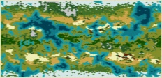
This is a 160x160 Civ3 map of Venus, based on radar scans of that planet's surface. It works best with 8-16 civs.
I put sea level at the median height, which means that roughly 50% of the map is sea and 50% is land. This in turn means that there is more land available than for a normal map of this size, so I increased the optimal number of cities such that you can create big empires without suffering from crippling corruption. This is the only rule change.
Terrain and resources follow Earth standards, although this could never be considered truly "realistic" (coal and oil deposits would be hard to explain even on a terraformed Venus).
Have fun!
Richard