Ultima Thule (Large PTW) - the frozen North!

JAbbate

Chieftain
Joined
Aug 28, 2001
Messages
19
Are you up to the challenge of The Great White North? This Large PTW map is centered at the North Pole and extends down to roughly 60 degrees North latitude. Most of it is within the Arctic Circle and there's nothing much besides Tundra, Pine Forests, and Mountains. There are set starting locations for up to 9 civs. Resources are balanced and placed realistically as much as possible.

You'll probably have to come up with a new game plan to survive here, cities are going to be small unless you can put them on the coasts. I've tried to make this map difficult but still enjoyable: I'd appreciate any comments, suggestions, etc. I've game-tested the map as the Vikings (it seemed appropriate) - any ideas as to which civ you think would be the best to play here?

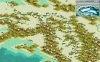
Enjoy (there's a screen shot in the next post)

This is the revised file Thule11.zip (old version was downloaded 88times)
 

Attachments

Here's a piece of North America
 

Attachments

  • ultima thule.jpg
    ultima thule.jpg
    46.2 KB · Views: 1,052
I really like the concept, but there's some kind of bug where I can't get from the far left of the map to the far right (or vice versa.) In other words, when playing a normal map, one can travel to the west edge of the map, and 'come out' on the east side. This map just stops me on the edges. Any solutions for this?
 
It's supposed to be like that. Why would you sail from Alaska to Iceland in a minute? This map is obviously flat, as it is supposed to be. Welcome to CFC, btw.
 
You're right, of course, Finland isn't all tundra which is why there is a spot of green in the south. Unfortunately for Finland, making it greener unbalanced play badly - nothing personal, you understand...:)
 
Originally posted by Hookah
its canada!

:confused:

Hmm? I see a lots of green grass around me. And I live in Canada.

This map looks great BTW. Wonderful job.
 
I think you should put some grasslands near each start location, make it a little easier.
 
this is such a fun map. its just so cool being on the ice it makes it hard byt v fun :)
 
Here in Michigan we know all to well the power of the ice age.
The Porkcupine Mountains were once part of a great volcanic range that has been thought to have had a max elv from 3,000 to 6,000 feet tall. But when the ice came to the midwest, it turned the proud peaks into mere foothills barely 2,000 feet high and made 5 of the biggest lakes on earth. Lake Superior is over 1,000 feet deep and somehow the largest freshwater lake in the world. It is not in surface area that title belongs to the Caspian Sea.
 

Attachments

  • porkie1.jpg
    porkie1.jpg
    16.9 KB · Views: 770
Ultima Thule has been revised to version 1.1. I've made some changes to the map and resource placement and have added two new resources: Seals as a bonus, and Polar Beasrs as a luxury. This should give a better picture of the tundra economy. See the first post in this thread for the revised file.
 
Map looks great :thumbsup:

Could someone convert this to *.biq for me? My editor is not being very helpfull, as it keeps saving it as a *.bix, even though it says it'll save it as *.biq. Perhaps it's a bug? :hmm:
 
Raw is War?:

- Don't know why the editor is giving you a problem but here's the biq version of Ultima Thule. Enjoy.

Joe
 
Don't know why the editor is giving you a problem but here's the biq version of Ultima Thule. Enjoy.

Thanks alot Joe :)
 
Back
Top Bottom