• We are currently performing site maintenance, parts of civfanatics are currently offline, but will come back online in the coming days. For more updates please see here.
Hypnotech3's Huge Earth

300x300 PTW real world map - no resources, just terrain 2016-10-05

hypnotech3

Chieftain
Joined
Dec 21, 2003
Messages
14
Location
Canada
Hi all,

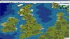
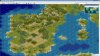
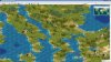
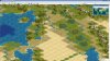
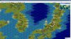
Never posted here before. I've just done up a 300x300 real world map for Civ3 PTW (*.bix).

I love El Mencey's and Marla Singer's huge real-world maps, but wanted to try something different. I felt there was a lot of "wasted space" on these maps - huge oceans, huge arctic areas, huge jungles, and so on where you won't get civilizations as much - so I decided to fudge a map of my own, with these areas shrunk.

I started with an Equirectangular Projection (same as Platte-Carree, I guess) - but then I did the following (in MS Photo, believe it or not):

- trimmed away all the arctic and antarctic (north of 75N and south of 60S);
- shrunk the far north (>55N) and far south (>45S) by 50%;
- shrunk the tropical region (20N to 20S) by 50%;
- shrunk the Atlantic (from Newfoundland to Ireland) by 50%;
- shrunk the Pacific (from Vancouver I. to Japan) by 50%.

As a result, this map shows only 45% of the true earth's surface area - thus it's got a lot more concentration on the temperate zones, which is what I was aiming for.

The map is unfortunately still a bit too big - you'll probably run into the 512 cities problem, as there's about 15000 settleable squares (if you disallow building cities in deserts, tundra and mountains). It also could be argued that it's too easy to go east-west on this map - I don't mind, as it seems most real-world civs have travelled east-west more than north-south.

Anyway, this map has no resources on it. I play a modified DYP rules pack, so me giving you my resources would just be confusing. But I wanted to give you guys this map, to say thanks for the years I've played on El Mencey and Marla's maps.

I hope the attachment is here....
 
I hope the attached file below is a screenshot - the minimap of the world, plus the area from Bulgaria to Crete and Greece to the Caucasus.
 

Attachments

  • untitled.jpg
    untitled.jpg
    188.5 KB · Views: 1,363
That is one big map.

You could take another screen picture with the map zoomed out to get more area in one pict.
 
I think that was at max zoom.

Anyway, the pic was mainly there to show the minimap, and the fact that I have multiple kinds of terrain.
 
Yup, I did it all the hard way.

1) download a high-quality Equirectangular projection jpg from Wikipedia.
2) Used trim, cut and paste (along with re-sizing) in MS Photo to assemble a new jpg shaped the way I like it.
3) Brought it into AutoCAD as an image, drew a civ grid over it, and printed it out.
4) Did each square by hand in the map editor. Coiasts first, then filled in.
5) Did the terrain by looking in atlases. Relief maps and agricultural use maps together.
6) Looked up some other stuff on Wikipedia to get details of various countries.
 
I've been looking for a big map such as this one to replace the one i've been using since a few months after civ3 came out ;) The city limit problem wont be a problem because I limit settler production in my mod.

Only one issue with this map, although its much larger than my 180x180 map, mine has some important areas of the world enlarged, making them bigger than in your map, especially great britain, italy, greece, japan, and scandinavia.

Im considering working on this map, although it will take some time away from working on other areas of my mod. Want to ask you if you're still working on improving it or if you're done with this one? ;)
 
I've been adding resources since the last post, but haven't otherwise changed it much. I probably won't upload a newer version, since as I said I not only play the Double Your Pleasure (for PTW) mod, I've even changed that quite drastically for my own enjoyment.

If I do upload another, it'll be based on a different projection (probably), and a little smaller (maybe 320x240) to fix the city limit problem. I really, really hate running into that, and I'm a bit embarassed that this map was just a tiny bit too big.

If you want to use my map as a starting point and do things to it, knock yerself out. My entire existence is open-source.
 
Ok I'll keep that in mind ;)

If you start on that smaller version let me know how it goes, if I choose to use your map I'll only start working on it in a few days, may post here an updated version with altered coastlines and above mentioned enlarged areas, then start working on the resources which are different in my mod so i would keet that private until its ready for consumption :)

Btw, I use a very modified version of satyajedi's earth map, dont know if you'll find it here but maybe on apolyton, its old ;) I think accuracy is not the most important, why play in a map where you have huge oceans and an european continent that will soon get too crowded for the european civs?...

Thanks
 
Enlarged areas in Europe & Japan would indeed be welcome, simply for gameplay's sake.

That looks like a killer map, overall! WOW! (And the amount of work it took sounds mindboggling...)
 
I think I'll do some work on it, i'll post the changes here, but not before the end of the week. Wont add any resources though, they're different in my mod.
 
I think accuracy is not the most important, why play in a map where you have huge oceans and an european continent that will soon get too crowded for the european civs?...

I guess my map is an attempt at "modified accuracy". I'm assuming that all parts of the earth are important, but the per-acre usefulness of land on certain parts of the planet is lower than in other parts. So, I made the tropics smaller because while it's conducive to growing food maybe, it's not been proven conducive to building many advanced civilizations. Same for the arctic. And as for the oceans, I always thought it was silly that it should take a trireme from 500 to 700 AD to sail from Scotland to Labrador - the oceans are there for barriers only, they can be a fair bit smaller without hurting gameplay. And why would Greenland need more than 1 square, unless we're playing "Arctic Seal Hunting" or "Sid Meier's SimIceHotels"?

As for the european civs, in my own homebrew mod I only have Britons, Euskadi, Iberians, Mycenae, and generic "Indo-Europeans". I long ago decided to spread the starting civs out more because of the dumb things that happen when civs start too close (e.g. everyone decides to send 1 settler to Siberia).
 
Agreed, I give higher movement costs in oceans in my mod, also make them impassable for wheeled units and give the wheeled flags to all pre caravel ships (except the viking longboat and one other), so you wont see any galleys reaching america ;)
 
I think I'll do some work on it, i'll post the changes here, but not before the end of the week.
Take your time, I'm not in any rush. Have fun!
 
Ok here it is, I call it revision 1, there might be others by myself or someone else. What I did, from what I can recall:

Touched iceland a bit;
Did significant changes to great britain and ireland;
Scandinavia as well, made it less horizontal;
Touched some parts of northern russia and germany;
Significant changes to the iberic peninsula, portugal just wasnt there;
Touched italy, greece and the surrounding islands quite a bit;
Slight modifications all over asia minor and the near east which include:
Eastern mediterranean coast, terrain more friendly (for the Phoenicians);
Fertile crescent, less deserts around the rivers, im sure they named it fertile crescent because it had fertile land; :p
Couple of rivers is southern iran, terrain more friendly (for Elamites or Persians);
Added a big river is Saudi Arabia, read the other day some scholar uncovered evidence of a possible ancient river in that area, terrain slightly more friendly (for the Nabateans of Arabs);
Small changes in north africa;
Some changes in india;
Slight modifications in china;
Some in korea;
Significant changes to japan;
Slight modifications to oceania's islands, mostly coastlines;
Some in australia and new zealand as well;
Few in south africa;
Lots of changes in south america, there was a huge chunk missing in eastern brazil, changed the rivers;
Some modifications in central america and the caribbean;
Some modifications in north america as well.

And thats it. I kept it PTW so there are no volcanoes or marshes, and didnt work on resources. If anyone wants to continue work on this, please post here soon because i'll soon continue work on this map but it will be tied to my mod and wont post here since i have customized resources and some terrain.
 

Attachments

Yep it is :)
Probably not a good idea to play on it using default rules, because you'll get tons of cities very quickly. But if using with a mod that limits expantion, it should be very cool. Im planning on only allowing settlers to be built up to a certain tech, then have settlers be auto produced by certain wonders.

Here are some screen shots of the map in some interesting locations:
 

Attachments

  • 1.jpg
    1.jpg
    329.7 KB · Views: 422
  • 2.jpg
    2.jpg
    336 KB · Views: 338
  • 3.jpg
    3.jpg
    342.5 KB · Views: 331
  • 4.jpg
    4.jpg
    342.6 KB · Views: 339
  • 5.jpg
    5.jpg
    324.4 KB · Views: 337
It´s a nice map but still looking somewhat too small in some important regions. Did you have a look on the Aeldrik world-map in Rocoteh´s WW 2Global ?
 
Back
Top Bottom