Globex
President Scorpio
- Joined
- Mar 16, 2007
- Messages
- 437
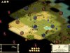
Look at my dotmap below.
The blue dots are where I am planning to build cities
The orange dots are where I think my cites are going to be but I am unsure because of my limited knowledge of the surrounding terrain.
Are my city placement abilities good, okay, below par?
Have any tips to help improve my city placement skills or any comments on the map?
Edit: For some reason, I can't upload the image.
I click upload and the window says that the uploading is done but the file isn't attached.
Edit: I got the image uploaded.
Thank you Tone for pointing me towards the announcement.
Thanks Overseer for pointing me to photobucket and imageshack (too lazy to make an account right now but will if I find the need to upload images more frequently)
")
") )
)