Colony Information Screen

sedna17

Emperor
Joined
Mar 12, 2008
Messages
1,091
I haven't had time to make contributions to this mod for a while, but I've enjoyed playing the latest betas. Thanks to the rest of the team for all their amazing work.

One thing I find annoying in the late game is keeping track of colonies. The Top 5 Cities/Wonders screen provides the information about which wonders have been built, but not in a particularly useful way. If I'm attempting to build 5 colonies I want to know which areas are still largely unpopulated so that I can take advantage of the production bonus from having North American/South American/etc. access.

I have the basic code for a new screen working now. Each empty colony slot shows up on the map, and when someone founds a new colony the color changes and their flag goes up there. Obviously this example is just with some dummy data so I didn't have to run a game until the colonial era. Hovering over the colony circle shows the civopedia entry so you can browse for likely targets.


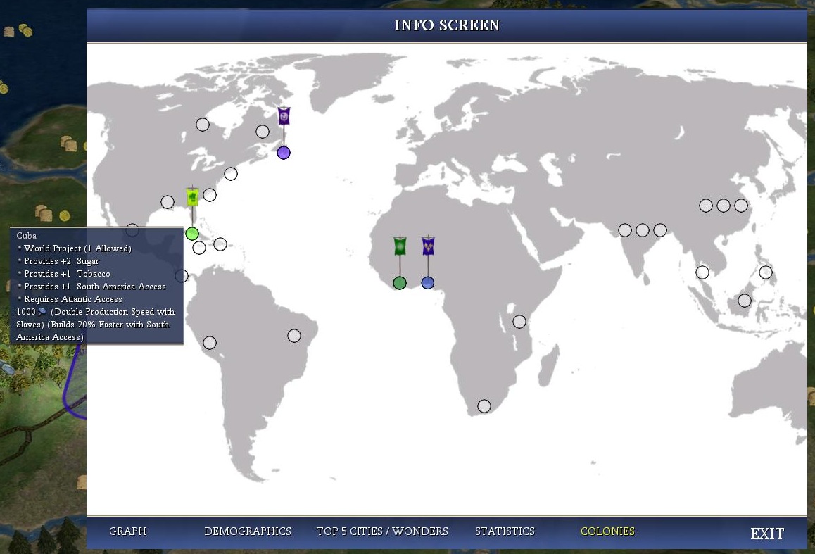
Do people approve of including this? I'll take suggestions for additional features, but there are only a limited set of things that are easy with the interface API, so keep that in mind.
 

Attachments

  • ColonyScreen.JPG
    ColonyScreen.JPG
    155.4 KB · Views: 833
Couple of comments:

- it looks awesome
- it will be useful
- it will give more "flavor" the whole colonization aspect of the game
- it will not interfere with anything of what we are doing in the rest of the mod
- you should go ahead and add this

Are you coming back to full time coding for the final stretch?
 
I think it's a great idea. Good way to keep track of it. Similar to building a space shuttle or something along those grounds.
 
Couple of comments:

- it looks awesome
- it will be useful
- it will give more "flavor" the whole colonization aspect of the game
- it will not interfere with anything of what we are doing in the rest of the mod
- you should go ahead and add this

Are you coming back to full time coding for the final stretch?

It's awesome. I can't wait until this will be included.

Wow, this is amazing
Agree with everything the others said :king:
 
Wonderful idea. Perhaps a ~17th century map would be more flavourful?

It's also a good idea, but not necessary at all
Maybe if we can find an ideal 17th century map for this, and it won't be too much extra work for Sedna
 
I'm afraid I won't be coming back to coding full time. I'll try to do odds and ends here and there.

Swapping in another map is not too hard. I just need to identify new coordinates in the map. The old maps here do look nicer and are more atmospheric. Only the first one (http://2.bp.blogspot.com/_KEOd_sgYs.../s1600/Kopie+(3)+von+OrteliusWorldMap1570.jpg) is big enough.

The only problem with the older maps is that in some of them it becomes hard to identify/place real places. In the above example the Hudson Bay and the Philippines are both poorly drawn. I could certainly place markers for those colonies, but it certainly wouldn't be as obvious. The classic trade off between clarity and reality.

I'll update the SVN with my current stuff (modern map) tonight after I finish a few things. There are still some "hack-y" parts that will make this screen a pain to keep up-to-date. Specifically:

  1. The flags are easy to add in XML-driven way. The circles, surprisingly, are not. I actually have a different colored circle graphic for each civ. I think our civ list is fairly settled, but of course this system makes things difficult for modmods that want to extend or change the civ list. I need to see if I can find a better way.
  2. The coordinates for the colonies are defined in Python. We already have lots of constants defined in the Python files, so this isn't too much of a problem, but it is one more thing to update if/when we change the list of colonies.
  3. I current "cheat" in the Python to draw the Indian and Chinese colonies three times. This information is in the XML though, so I just need to figure out how to access it.
 
The flags are easy to add in XML-driven way. The circles, surprisingly, are not. I actually have a different colored circle graphic for each civ. I think our civ list is fairly settled, but of course this system makes things difficult for modmods that want to extend or change the civ list. I need to see if I can find a better way.
[/LIST]
The colored circle is nice but the flag would be enough to identify the owner. I think for modmodders it would be ok if you could add a default color that is used whenever a civ has no own circle graphic. So that the screen would not break when you add a new civ. Not all civs build colonies anyway.

Great work :goodjob:
 
This is a fantastic idea
 
The only problem with the older maps is that in some of them it becomes hard to identify/place real places. In the above example the Hudson Bay and the Philippines are both poorly drawn. I could certainly place markers for those colonies, but it certainly wouldn't be as obvious. The classic trade off between clarity and reality.

http://www.upa.pdx.edu/IMS/currentprojects/TAHv3/Content/Maps/World_Map_1799.jpg

Perhaps this would be ideal then? 1799, almost completely accurate, but still has the "old map" feel.
 
The idea is awesome, but I think I prefer the modern map. The problem with old maps that only a few or none of them are compatible with a proper UI, which is one of the best features of the map you currently have.
 
I also prefer the current (modern gray one). It is the most clearest of them all and the most accurate. And IIRC, the buttons of the colonies are based on this map. So the buttons and the map will correspond.

An idea: A link from the map to the civilopedia. When you click on the dot of a colony, you'll automatically open the civilopedia page of the corresponding colony.

@ Sedna
Is it possible to move the new added artfiles into the FPK (when you are finished ofcourse) or will they not work properly in the PFK like the wondermovies?
 
Thanks for your suggestions Morholt, but I'm going to stick with the modern map for now. You'll be happy to know that there is now a fallback icon for civs without their own custom-colored button, so at least this shouldn't break your modmod.

An idea: A link from the map to the civilopedia. When you click on the dot of a colony, you'll automatically open the civilopedia page of the corresponding colony.

This should be easy to add.

@ Sedna
Is it possible to move the new added artfiles into the FPK (when you are finished ofcourse) or will they not work properly in the PFK like the wondermovies?

They should work inside the FPK, though I haven't tested it. I'll move them there when I'm happy that everything is complete.
 
Wow that is impressive!

Can't wait for this to be added in.

On something of a side-note, this map illustrates the lack of actual South American and Australian colonies, something I didn't really think about before. But seeing as how the mod stretches all the way to the year 1800, you guys may want to add a couple more colonies (just an idea).

First Australian colony was settled in 1788AD, but the bulk of the colonization happened after the time period of the mod.

For South America, we do include most of the territory, it is just that it is divided into only two parts (unlike the Northern part, which is more fractured).
 
I just got the latest SVN version. Looks great.

I am wondering if it will be better to add all the flags in Europe too so that it stands out. Just the flags on the approximating spawn locations, statically as part of the background image. Maybe without the circles underneath, just simple flags.

Then you will see Europe with all the flags on top of each other and the sparsely spread colonies all over the world.
 
Top Bottom