Provolution
Sage of Quatronia
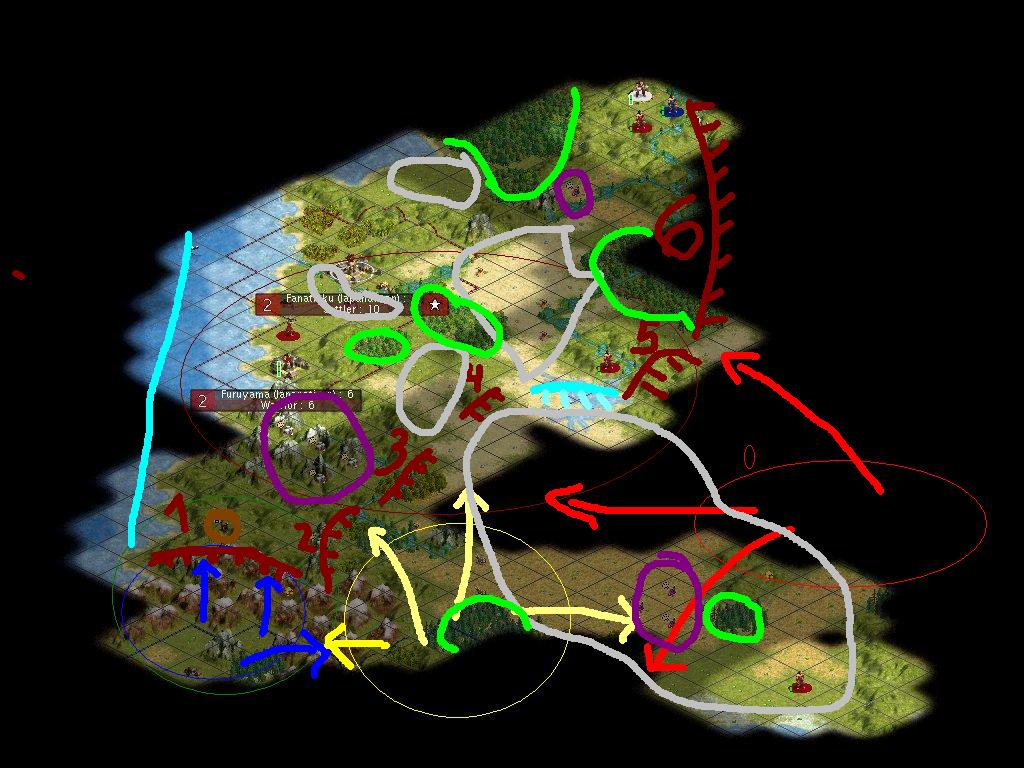
This FOREIGN AFFAIRS MAP, Intelligence Report 2350 BC is developed by the Japanatican Expansion & Security Team (JEST), which has done us the favor in developing this complementary intelligence map for the help in developing a holisitical doctrine around assuring expansion, strategic resources and defensible
borders for Japanaticas 2nd Term.
First of all, in order to understand the map legend.
Ellipses:
Dark Red: Japanatica (Militaristic, Religious)
Light Red: Imperial Rome (Militaristic, Commercial)
Yellow: Zulu (Militaristic, Expansionist)
Dark Blue: Babylonia (Scientific, Religious)
Grey areas are open plains, grasslands and deserts, cavalry terrain
Green areas are forests/Jungles, ambushing/defense terrain
The remaining areas are mostly hills and ountains, fortifiable terrain
The Dark Red Numbered Border Positions (NBO) are marked as red lines with spikes on them, and these are numbered from One to Six, in slight overlap with the Domestic Ministry Migration and Urbanization Plan.
Brown marks strategic resource, here horses, for the cavalry
Violet marks the luxury spots, within our reach diamonds and wines.
In this plan, it is important to consider tha domestic expansion and military development will impact foreign relations and vice versa. I am proud to announce that Japanatica has changed from an initial posture of appeasement, where we gave away 20 gold for 3 turns of Bronze research, and changed that into a stunning diplomatic success. For our knowledge of the wheel, we managed to negotiate pottery and warrior code, bringing us so much closer to our designated goal of enlightened monarchy. We are 12 turns away from iron working, and may develop a sound strategy to occupty Iron for a city in two turnchats. I will ask specifically to line up a settler specifically for buildiing an iron ore city for that turnchat.
An extension to the already fledgling relationship with the Zulus, was that they offered their workforce for a bargain price of 30 gold, effectively doubling the Japanatican workforce with unskilled Zulu Labor.
I am proud to announce that Japanatica is already a multiethnic nation.")
The main vision of this plan, is to do as Emperor Augustus, Dividem et Rulem, and build a defensible border till the Samurai is complete in Term 2.
Finally, I agree with the Domestic plans in general as laid out, and line up with Fier Canadien in that we must envelop from the center, by building a city there, and then expand immediately to halt Babylonian expansion north to the
Gem Mountains (Yotsubishi Yama). The strategy would be to develop defensivle systems 4, 3, 1, 2 and then finally 5 and 6 in that order.
This is a long term strategy from Foreign Affairs designated to build better relations with the Babylonians in the South, and to assure that the Romans will fight the Zulus for the Southern Grape Plains, the Famous Grapes of Wrath Steppes. In this system, fortifications on the hills, using the Huge Lake as a defensible border and a mobile reserve of cavalry, will keep our defense
needs until the day of the samurai, converting the mobile cavalry reserve into
Samurai, 100 % in line with Minister Sarevok and General Falcon02's plans.
This strategy is also fully compatible with plans drafted by Domestic Minister Noldodan, in drafting specialized resurce cities.
This strategy is also fully compatible with the science department, as this plans focuses cities near commerce bringing diamonds and rivers.
Finally, culture would have a major impact in defining overlapping zones, so I am curious to see how the Ministry of culture can embed plans for our easily built temples into this equation. I am all open minded, and propose this general strategy open to all ministers and citizens to provide fresh ideas.
And I am perfectly fine with roles, no Minister needs to pretend to be a Citizen and vice versa. That is the end of this intro.
Please speak your mind people, the floor is open.
borders for Japanaticas 2nd Term.
First of all, in order to understand the map legend.
Ellipses:
Dark Red: Japanatica (Militaristic, Religious)
Light Red: Imperial Rome (Militaristic, Commercial)
Yellow: Zulu (Militaristic, Expansionist)
Dark Blue: Babylonia (Scientific, Religious)
Grey areas are open plains, grasslands and deserts, cavalry terrain
Green areas are forests/Jungles, ambushing/defense terrain
The remaining areas are mostly hills and ountains, fortifiable terrain
The Dark Red Numbered Border Positions (NBO) are marked as red lines with spikes on them, and these are numbered from One to Six, in slight overlap with the Domestic Ministry Migration and Urbanization Plan.
Brown marks strategic resource, here horses, for the cavalry
Violet marks the luxury spots, within our reach diamonds and wines.
In this plan, it is important to consider tha domestic expansion and military development will impact foreign relations and vice versa. I am proud to announce that Japanatica has changed from an initial posture of appeasement, where we gave away 20 gold for 3 turns of Bronze research, and changed that into a stunning diplomatic success. For our knowledge of the wheel, we managed to negotiate pottery and warrior code, bringing us so much closer to our designated goal of enlightened monarchy. We are 12 turns away from iron working, and may develop a sound strategy to occupty Iron for a city in two turnchats. I will ask specifically to line up a settler specifically for buildiing an iron ore city for that turnchat.
An extension to the already fledgling relationship with the Zulus, was that they offered their workforce for a bargain price of 30 gold, effectively doubling the Japanatican workforce with unskilled Zulu Labor.
I am proud to announce that Japanatica is already a multiethnic nation.
The main vision of this plan, is to do as Emperor Augustus, Dividem et Rulem, and build a defensible border till the Samurai is complete in Term 2.
Finally, I agree with the Domestic plans in general as laid out, and line up with Fier Canadien in that we must envelop from the center, by building a city there, and then expand immediately to halt Babylonian expansion north to the
Gem Mountains (Yotsubishi Yama). The strategy would be to develop defensivle systems 4, 3, 1, 2 and then finally 5 and 6 in that order.
This is a long term strategy from Foreign Affairs designated to build better relations with the Babylonians in the South, and to assure that the Romans will fight the Zulus for the Southern Grape Plains, the Famous Grapes of Wrath Steppes. In this system, fortifications on the hills, using the Huge Lake as a defensible border and a mobile reserve of cavalry, will keep our defense
needs until the day of the samurai, converting the mobile cavalry reserve into
Samurai, 100 % in line with Minister Sarevok and General Falcon02's plans.
This strategy is also fully compatible with plans drafted by Domestic Minister Noldodan, in drafting specialized resurce cities.
This strategy is also fully compatible with the science department, as this plans focuses cities near commerce bringing diamonds and rivers.
Finally, culture would have a major impact in defining overlapping zones, so I am curious to see how the Ministry of culture can embed plans for our easily built temples into this equation. I am all open minded, and propose this general strategy open to all ministers and citizens to provide fresh ideas.
And I am perfectly fine with roles, no Minister needs to pretend to be a Citizen and vice versa. That is the end of this intro.
Please speak your mind people, the floor is open.


") *
*