You are using an out of date browser. It may not display this or other websites correctly.
You should upgrade or use an alternative browser.
You should upgrade or use an alternative browser.
Gigantic Accurate Earth Map (232 x 112)
- Thread starter Laskaris
- Start date
I like the look of Lambert cylindrical equal-area projection.
Good work on the map even if it is way to large for me to play on it.
The Lambert equal-area projection is a nice one, yes. Personally, from an aesthetic point of view, I prefer the Hobo-Dyer equal-area projection which I used here. To me, the height / width aspect ratio of the Hobo-Dyer projection of about 2.0 looks better than the 3.14... aspect ratio of the Lambert projection. But that really is a question of personal taste.
I plan to release a Eurasia cutout of the map eventually, which will make at least a large part of it playable for people who can't play the full map because their PC can't handle it.
RodneyG668
Chieftain
- Joined
- Feb 16, 2013
- Messages
- 1
does this map start each civ. in its proper location?
does this map start each civ. in its proper location?
Yes, civilizations start in their historically accurate starting locations. The only exceptions to this are some "filler" civilizations in the map versions for basic Civilization and Warlords, where I placed the English in South Africa, for instance.
The 18 civilization version for Beyond the Sword has the following civilizations, all in their accurate starting locations: Arabian, Aztec, Babylonian, Carthaginian, Celtic, Chinese, Egyptian, Ethiopian, Greek, Incan, Indian, Japanese, Khmer, Malinese, Mayan, Mongolian, Native American, and Zulu. The 12 civilization version for Beyond the Sword has: Arabian, Babylonian, Carthaginian, Celtic, Chinese, Egyptian, Greek, Indian, Japanese, Khmer, Mongolian, and Ottoman (the Ottomans start out in Central Asia, which actually makes sense for a Turkic civilization).
MotezumaMan
Warlord
I love it! The only thing that kind of disappointed me was the lack of the Haida Gwaii (Queen Charlotte) islands and Vancouver Island, these are major islands in Canada; Victoria, located on Vancouver Island is the capital of British Columbia.

I love it! The only thing that kind of disappointed me was the lack of the Haida Gwaii (Queen Charlotte) islands and Vancouver Island, these are major islands in Canada; Victoria, located on Vancouver Island is the capital of British Columbia.
Haida Gwaii is on the map, it's the island at x=30, y=99. Vancouver Island is there as well, but very abstracted: the peninsula at x=34, y=97. Because Vancouver Island is so close to the mainland, and because I wanted to get the Strait of Georgia and the Juan De Fuca Strait to the east and north-east in, that's how it turned out at this map resolution. It's a mountain tile, which depicts the ultra-prominent peak of Golden Hinde. I might have taken a hill to make it settleable, but as a rule, I modelled ultra-prominent peaks as mountains on this map.
Anyway, I'm glad you like the map despite its flaws. Thank you for your comment.
volandemord
Chieftain
- Joined
- Jan 31, 2013
- Messages
- 13

Download the Gigantic Accurate Earth Map
Warning: This truly is a gigantic map in size and will strain your PC. At 232 x 112 = 25984 plots, it is significantly bigger than Genghis Kai's Giant Earth Map (210 x 90 = 18900 plots) and slightly bigger than Carter's Earth Map (192 x 120 = 23040 plots). In other words, you will need a good amount of RAM to run this map!
About this map:
The Gigantic Accurate Earth Map has the same design philosophy as my older, smaller Accurate Earth Map. It uses a cylindrical equal-area projection to represent all the continents and oceans with their correct size relative to each other, and I spent a great amount of time placing the terrains, rivers and resources as accurately as possible. The bigger size of this map, 232 x 112 plots compared to "only" 132 x 64 of the old one, allowed for an even finer scale. Here is a bigger screenshot for a closer look at the Gigantic Accurate Earth Map:
Spoiler :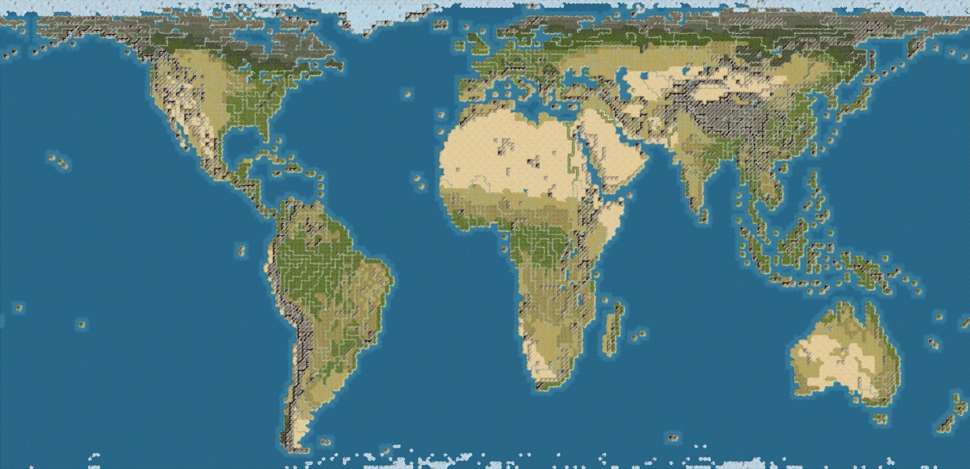
Obviously, it is impossible to make a perfectly accurate Earth map for Civilization. The Earth is a globe, so any representation of its surface on a plane is a compromise of one form or another, accurately representing some of the properties of the Earth's surface at the expense of distorting others. That is why geographers have invented various different map projections for different purposes.
Rather than a boast of perfect accuracy, calling my maps "Accurate Earth Maps" is simply a declaration of intention and design philosophy. Unlike many other Earth maps for Civilization IV (including the official one), mine do not feature an artificially enlarged Europe and Japan or an artificially reduced Pacific ocean. Instead, I went for as much geographical accuracy as possible, within the limitations of the game. The result are some Earth maps that, in my view, are very interesting and unique. And while they don't allow you to cram half a dozen civilizations into Europe, they make for a great game in other ways.
Because cities and the plots they occupy are in many ways the core of the game, I decided that preserving area was the most important aspect of geographical accuracy in Civilization, rather than preserving shape or distance. I used a cylindrical equal-area projection with standard parallels at 37.3 degrees north and south of the equator (sometimes known as the "Hobo-Dyer projection"). All continents and oceans are depicted with their correct areas relative to each other. Australia really is three quarters the size of Europe, Africa really is 14 times the size of Greenland, and so on.
I did a lot of research on terrain, river and natural resources placement. I used a vegetation map from NOAA (National Oceanic and Atmospheric Administration) for the biomes, and The World Ultras Homepage for a list of all the mountains with a prominence of more than 1500 meters (which in my map became mountains instead of mere hills). For resources, I used essays like Forecasting Coal Production Until 2100 by Evans and Mohr to get figures of worldwide coal reserves at the beginning of the industrial age, and then distributed that resource accordingly. I placed oases at geographically appropriate locations like Tafilalt in Morocco or (a bit of an inside joke, but accurate nonetheless) Las Vegas in the US.
I created the map using Civ 4 Map Editor and MapView 2.0. As a basis for the map, I primarily used the maps from the Natural Earth III website, which I converted to the cylindrical equal-area projection with a map projection program called Geocart 3 and overlayed one on top of the other with Adobe Photoshop Elements.
As you can see, a lot of work went into this map. I hope that you like the result. Have fun, and don't hesitate to send feedback and comments!
Inside the .zip archive:
There are nine maps inside the .rar archive. Three for basic Civilization IV, three for the Warlords expansion, and three for the Beyond the Sword expansion. For each version of the game, there is one "blank" map with no civilizations set, one that has 18 civilizations already set up around the globe, and one that has 12 civilizations already set up in Eurasia and North Africa, but none in sub-Saharan Africa or the Americas, to give you more of a new world to explore and more of that Guns, Germs and Steel feeling.
Most of the civilizations start out in their historically accurate starting locations. For the maps for basic Civilization and Warlords, I also had to place some in non-accurate starting locations to get a better distribution, like the English in South Africa or the French in Indochina. The 18 civilization version for Beyond the Sword has the following civilizations, all in their accurate starting locations: Arabian, Aztec, Babylonian, Carthaginian, Celtic, Chinese, Egyptian, Ethiopian, Greek, Incan, Indian, Japanese, Khmer, Malinese, Mayan, Mongolian, Native American, and Zulu. The 12 civilization version for Beyond the Sword has: Arabian, Babylonian, Carthaginian, Celtic, Chinese, Egyptian, Greek, Indian, Japanese, Khmer, Mongolian, and Ottoman (the Ottomans start out in Central Asia, which actually makes sense for a Turkic civilization).
To use the maps, you need to extract the appropriate files to the appropriate PublicMaps folder. For basic Civilization IV, extract the *.Civ4WorldBuilderSave files to the PublicMaps folder inside your Civilization IV directory. For Warlords, extract the *.CivWarlordsWBSave files to the Warlords\PublicMaps folder. For Beyond the Sword, extract the *.CivBeyondSwordWBSave files to the Beyond the Sword\Public Maps folder.
an excellent map was done I only Africa changed the deserts did less than
volandemord
Chieftain
- Joined
- Jan 31, 2013
- Messages
- 13
Laskaris and you could not impose this map on fashions with new resources fashion RedForce.SB 1.4.6 thanks in advance
an excellent map was done I only Africa changed the deserts did less than
Laskaris and you could not impose this map on fashions with new resources fashion RedForce.SB 1.4.6 thanks in advance
Regrettably, I have no idea what you are trying to say there. I guess English is not your native language (it isn't mine, either). If you word your comments in a way that makes sense, I will be glad to answer any questions you might have.
Sync
Warlord
Excellent earth map, the best one I've seen.
If you don't mind me saying though, I think the United Kingdom is actually smaller than what is displayed on your map.
Great work though.
If you don't mind me saying though, I think the United Kingdom is actually smaller than what is displayed on your map.
Great work though.
Thanx for the map, I like it.
The only thing I would wish for would be a Revolution Mod with more than 18 Civilizations and some Customization like on the GiantEarthMap (for example, ships having +1 movement points.) Anyway, I can do it for myself once I have some time.
The only thing I would wish for would be a Revolution Mod with more than 18 Civilizations and some Customization like on the GiantEarthMap (for example, ships having +1 movement points.) Anyway, I can do it for myself once I have some time.
Thank you for your comments. I'm glad that you like the map.
The island of Great Britain is about 20% larger than it should be while the island of Ireland is some 10% smaller. As is necessary when you translate a map with a square overlay into a game map where a square is either 100% land or 100% water, small inaccuracies are introduced, especially when you try to make the shape of an island like Great Britain recognizable. Still, the overall error in area for the British Isles is small, only 12%.* You must have pretty good eyes to spot that!
(*The map is 232 x 112 tiles, with Antarctica cut off. A full world map in this resolution, including Antarctica, would have 232 x 118 = 27376 tiles. The Earth's surface is 510,072,000 km2. So, one tile of the map represents approximately 18,632 km2 (510,072,000 km2 divided by 27376 tiles). The islands of Great Britain and Ireland together have an area of about 314,269 km2 (229,848 km2 for Great Britain and 84,421 km2 for Ireland). 314,269 km2 divided by 18,632 km2 is 16.87, which means that the islands should occupy about 16.87 tiles in the map. They occupy 19 tiles (15 for Great Britain and 4 for Ireland), which means that, yes, they are together some 12% larger than they should be.)
You are free to modify the map and re-publish it. If you do, please give me credit for the original.
If you don't mind me saying though, I think the United Kingdom is actually smaller than what is displayed on your map.
The island of Great Britain is about 20% larger than it should be while the island of Ireland is some 10% smaller. As is necessary when you translate a map with a square overlay into a game map where a square is either 100% land or 100% water, small inaccuracies are introduced, especially when you try to make the shape of an island like Great Britain recognizable. Still, the overall error in area for the British Isles is small, only 12%.* You must have pretty good eyes to spot that!
(*The map is 232 x 112 tiles, with Antarctica cut off. A full world map in this resolution, including Antarctica, would have 232 x 118 = 27376 tiles. The Earth's surface is 510,072,000 km2. So, one tile of the map represents approximately 18,632 km2 (510,072,000 km2 divided by 27376 tiles). The islands of Great Britain and Ireland together have an area of about 314,269 km2 (229,848 km2 for Great Britain and 84,421 km2 for Ireland). 314,269 km2 divided by 18,632 km2 is 16.87, which means that the islands should occupy about 16.87 tiles in the map. They occupy 19 tiles (15 for Great Britain and 4 for Ireland), which means that, yes, they are together some 12% larger than they should be.)
The only thing I would wish for would be a Revolution Mod with more than 18 Civilizations and some Customization like on the GiantEarthMap (for example, ships having +1 movement points.) Anyway, I can do it for myself once I have some time.
You are free to modify the map and re-publish it. If you do, please give me credit for the original.
kristopherb
Protective/Charismatic
Great map, I can quickly open this map in a short amount of time (60s ish). I've yet to properly start a game with it yet but I assume most of the lag will come later. Either my new laptop is good or the lag will come later in the game.
still good map
still good map
Wonderful. I'm wondering, how can I get 30 civs to play at once on this map?
The extra civs components only seem to work for random maps.
I'm afraid I don't know the answer to that. I am a mapmaker and my expertise with other areas of modding is limited.
Your best bet probably is to ask the creators of the extra civs components how their work can be used with specific maps (instead of random ones), and maybe they can help you.
strategyonly
C2C Supreme Commander
The extra civs components only seem to work for random maps.
What is the Extra civ comp?
It's nice to see a discussion about map projection on this forum and for the purposes of Civ IV an area preserving map seems to be the "correct" choice as one of the most fundamental rule of the game is that "land is power".
I have to point out though that the degree of forestation you chose is most likely not accurate if the goal was to give a picture of earth without human influence. I think there is a consensus among historians that nearly all land bordering the Mediterranean was covered by forests in prehistorical times. With the advent of iron working these forrests were used to power smelting operations throughout Europe, Northern Africa and the Levante. Additionally there was an ever increasing demand for wood in the ship building industry and for general purposes of an exploding population such as clearing land for farming. There have been suggestions that extensive deforestation influenced, if not caused, the decline of the Roman Empire. This is admittedly shaky though.
I have to point out though that the degree of forestation you chose is most likely not accurate if the goal was to give a picture of earth without human influence. I think there is a consensus among historians that nearly all land bordering the Mediterranean was covered by forests in prehistorical times. With the advent of iron working these forrests were used to power smelting operations throughout Europe, Northern Africa and the Levante. Additionally there was an ever increasing demand for wood in the ship building industry and for general purposes of an exploding population such as clearing land for farming. There have been suggestions that extensive deforestation influenced, if not caused, the decline of the Roman Empire. This is admittedly shaky though.
I have to point out though that the degree of forestation you chose is most likely not accurate if the goal was to give a picture of earth without human influence. I think there is a consensus among historians that nearly all land bordering the Mediterranean was covered by forests in prehistorical times. With the advent of iron working these forrests were used to power smelting operations throughout Europe, Northern Africa and the Levante. Additionally there was an ever increasing demand for wood in the ship building industry and for general purposes of an exploding population such as clearing land for farming. There have been suggestions that extensive deforestation influenced, if not caused, the decline of the Roman Empire. This is admittedly shaky though.
Yes, the biome distribution of the map is based on climate maps of the present day rather than the prehistoric / ancient era. Moreover, one of the weaknesses of Civilization, in regards to creating accurate maps, is that the game does not distinguish between different types of forests. Because I don't really like representing Mediterranean forests / shrub with the standard warm forest feature that is already used for everything ranging from temperate mixed forests to monsoon forests, I opted for representing the Mediterranean climate as simple, forest-less plains.
You have a point, though - I could have added more forests around the Mediterranean. In future map projects, I will do that.
RyanTheGreat
Warlord
Laskaris, would you consider making a map that is in between the sizes of your 2 maps? I love your maps and think that from a gameplay perspective a size smaller that your gigantic map but larger than your standard map would be perfect. Cheers