Heightmaps CIV4ArtDefines_Terrain.xml

Vadus

pretend the impossible
Joined
Nov 23, 2003
Messages
374
Location
Northern Germany
The Great Apple said:
Hmmm - if you check out CIV4ArtDefines_Terrain.xml there are no links to .nif files in there. As I said above, I think they're all done by heightmaps.

I picked that up in a thread, and I want to go a bit deeper to this topic.
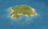
So it is right, that an isle, like on the attached image, is nothing but a bunch of height coordinates ?

Here the according extract from the CIV4ArtDefines_Terrain.xml
Code:
<TerrainArtInfo>
	<Type>ART_DEF_TERRAIN_GRASS</Type>
	<Path>Art/Terrain/Textures/GrassBlend.dds</Path>
	<Detail>Art/Terrain/Textures/GrassDETAIL.dds</Detail>
	<Button>,Art/Interface/Buttons/BaseTerrain/Grassland.dds,
          Art/Interface/Buttons/BaseTerrain_TerrainFeatures_Atlas.dds,
         3,1</Button>
	<LayerOrder>4</LayerOrder>
	<TextureBlend01>8,0</TextureBlend01>
	<TextureBlend02>1,0</TextureBlend02>
	<TextureBlend04>6,0</TextureBlend04>
	<TextureBlend08>5,0</TextureBlend08>
	<TextureBlend03>2,0</TextureBlend03>
	<TextureBlend06>10,0</TextureBlend06>
	<TextureBlend12>12,0</TextureBlend12>
	<TextureBlend09>9,0</TextureBlend09>
	<TextureBlend07>3,0</TextureBlend07>
	<TextureBlend14>14,0</TextureBlend14>
	<TextureBlend13>11,0</TextureBlend13>
	<TextureBlend11>4,0</TextureBlend11>
	<TextureBlend10>7,0</TextureBlend10>
	<TextureBlend05>13,0</TextureBlend05>
	<TextureBlend15>
         15,0 16,0 17,0 18,0 19,0 20,
         0 21,0 22,0 23,0 24,0 25,0 26,0 27,0 28,0 29,
         0 30,0 31,0 32,0
        </TextureBlend15>
</TerrainArtInfo>
So can anyone explain me, how I get an isle like below from such numbers ?
My goal is to create half spheres from this current isle form :scan:
 

Attachments

  • grassIsle.png
    grassIsle.png
    408 KB · Views: 210
ok, placing many grassland isles in the ocean shows that there are only some diffierent kinds of isle-forms. I counted 5 forms, from which there where more than one isle.
So maybe the first 14 TextureBlends are describing this different forms, which would be not nice, because then there is no easy possibility to change the isle form itself, only it's coastline ...
 
You can't edit the heightmaps via the XML. They have their own little greyscale images in the art directory somewhere.

I'll find the actual directory, but I need to unpak everything first. :)

Here we go: Civ4\Assets\Art\Terrain\heightmap has all the heightmaps.
 
so I guess all heighmaps greyscales for the flat terrain like grassland or plains are stored here ?
Assets\art\terrain\heightmap\flats

This folder has some tga's , but opening them with Paint Shop Pro 8 show me a whole grey picture, but only in one single color. Only the palette is full of greyscales ...

And I can't belive, that the curved coastline of a grassland isle is made from this grey texture files ? :confused:

EDIT : oh, well .. I see there are some better looking tga's in Assets\art\terrain\heightmap\coasts .
So the more brighter a pixel in that tga is, the more higher will the correspoding spot in the isle's coast be in the game ?
 
Vadus said:
so I guess all heighmaps greyscales for the flat terrain like grassland or plains are stored here ?
Assets\art\terrain\heightmap\flats

This folder has some tga's , but opening them with Paint Shop Pro 8 show me a whole grey picture, but only in one single color. Only the palette is full of greyscales ...

Well, the terrains are suppose to be flat. ;) So having it all the same color makes sense.


Vadus said:
EDIT : oh, well .. I see there are some better looking tga's in Assets\art\terrain\heightmap\coasts .
So the more brighter a pixel in that tga is, the more higher will the correspoding spot in the isle's coast be in the game ?

I think you may be looking for the .tgas in coastblendmasks. The only experiance I have with editing these is trying to make everything flat. It didn't work out so well.

Good Luck. :)
 
What, the, does the XML do?
 
vbraun said:
I think you may be looking for the .tgas in coastblendmasks. The only experiance I have with editing these is trying to make everything flat. It didn't work out so well.

Yes, same by me .. I changed all flat tga heightmaps to a more sphere like one but the flat terrain in the game is still flat :sad: So uses the game really these heightmaps??

attached my current flat heightmap

@Padmewan : I don't know !! to cryptic :confused:
 

Attachments

  • flat1_2.png
    flat1_2.png
    266 bytes · Views: 143
I have no idea what I wrote.

Is anyone in a position to contact Firaxis about this? This could end up being a graphics-engine "out of our control" thing?
 
Back
Top Bottom