Hurricane Dennis

Oh great, were going to get the remains of this hurricane too?
 
Gas Price Gouging Reported In Areas :mad:
By GARRETT THEROLF gtherolf@tampatrib.com

Published: Jul 9, 2005

TALLAHASSEE - Gov. Jeb Bush told reporters early Saturday morning that the state is receiving widespread reports of price gouging for gasoline as spot shortages took hold in the western Panhandle because of Hurricane Dennis.

``If there is gouging, I can assure you that the state will be taking action,'' Bush said. ``It's more than anecdotal information.''

Witnesses to the gouging were urged to report it to the state through a hotline at (800) HELP-FLA.

Florida law states prohibits a ``gross disparity`` from the average price of essential commodities during the 30 days immediately prior to the emergency. This applies unless the increase is attributable to additional costs incurred by the seller or to national or international market trends.

Violators of the price gouging statute are subject to civil penalties of $1,000 per violation up to a total of $25,000 for multiple violations committed in a single 24-hour period.

Widespread gasoline shortages causing long lines at the remaining pumps were also reported throughout the western panhandle as many residents filled tanks on their way out of town and as others stockpiled supplies.

Officials said the shortage was the result of distribution problems and not an underlying inability to bring gasoline into the state.

The Gulf of Mexico produces about 8 percent of the country's oil supply, and last year's Hurricane Ivan put some of that capacity out of operation for months.
 
Perfection said:
What about an electrical superstorm?
AHHH!!! Not the electrical superstorms!!!! That brings up painfull memories of thoes The Core flash ads o_O.
 
Speaking of superstorms, some stats for you to mull over:

Number of Hurricane Names Retired by Decade

1950s: 9
1960s: 11
1970s: 8
1980s: 7
1990s: 15
2000s: 13 – so far (not including Dennis, which will be retired, and any others 2005-2009)

Most Active Hurricane Seasons
Bold - Within the last ten years.
Italics - Within the last five years.


1. 1933 Season - 21 storms
2. 1995 Season - 19 storms
3. 1969 Season - 18 storms
4. 2003 Season - 16 storms
5. 2004 Season - 15 storms
6. 2001 Season - 15 storms
7. 2000 Seaonn - 14 storms
8. 1998 Season - 14 storms
9. 1990 Season - 14 storms
10. 1996 Season - 13 storms

Also of note:

Only Hurricane to develop in the South Atlantic: Catarina, 2004
Only Hurricane to strike Nova Scotia: Juan, 2003
Only Tropical Storm to develop between late December and early June: Ana, April 2003
Earliest Category 4 Hurricane: Dennis, July 2005
Strongest Hurricane to develop in July: Dennis, 2005
Largest Hurricane to develop in the Atlantic: Floyd, 1999
Most Hurricanes to Strike Florida in One Year: 4 (Charley, Frances, Ivan & Jeanne), 2004
2nd, 3rd, 4th and 8th costliest (respectively) Hurricanes to hit the US: Ivan, Charley, Frances, Jeanne, 2004

More intense hurricane seasons all the time :(
 
CivGeneral said:
Oh great, were going to get the remains of this hurricane too?

and also:

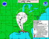
SATELLITE IMAGES INDICATE A TROPICAL WAVE LOCATED ABOUT 1450 MILES
EAST OF THE LESSER ANTILLES HAS CHANGED LITTLE IN ORGANIZATION THIS
AFTERNOON. CONDITIONS APPEAR FAVORABLE FOR SOME SLOW DEVELOPMENT
TO OCCUR OVER THE NEXT COUPLE OF DAYS AS THE WAVE MOVES WESTWARD AT
10 TO 15 MPH.

Wasting no time it seems with a second system forming.
 
2nd, 3rd, 4th and 8th costliest (respectively) Hurricanes to hit the US: Ivan, Charley, Frances, Jeanne, 2004

What was the first, Andrew? Or that large hurricane that hit Galveston in 1900?
 
Yes, Andrew was the costliest. The Galveston Hurricane killed a lot of people but resulted in relatively little property damage. Of course, the highest loss of life goes to the "Great Hurricane of 1780" (~22,000 people killed, mostly on Barbados or on French and British warships fighting in the Caribbean). However, loss of life is a poor measure of strength as modern hurricanes kill relatively fewer people due to better safety precautions, faster alerts and extensive evacuations, not because they are weaker.

Oh, and Dennis is back to Category 4 strength, maximum sustained winds ~135 mph (this from weather.com as weather.gov doesn't update over night).
 
The below chart compares the forecast tracks of different weather computer models. Seems like they are concentrating on where I lived last year: Mobile, Alabama.

Hope WillJ is okay.
 

Attachments

  • dennis13.gif
    dennis13.gif
    15.6 KB · Views: 104
Cuivienen said:
Also of note:

Only Hurricane to develop in the South Atlantic: Catarina, 2004
Only Hurricane to strike Nova Scotia: Juan, 2003
Only Tropical Storm to develop between late December and early June: Ana, April 2003
Earliest Category 4 Hurricane: Dennis, July 2005
Strongest Hurricane to develop in July: Dennis, 2005
Largest Hurricane to develop in the Atlantic: Floyd, 1999
Most Hurricanes to Strike Florida in One Year: 4 (Charley, Frances, Ivan & Jeanne), 2004
2nd, 3rd, 4th and 8th costliest (respectively) Hurricanes to hit the US: Ivan, Charley, Frances, Jeanne, 2004

More intense hurricane seasons all the time :(

Your statement about Nova Scotia is not true. In fact, the below snippet from an article says the opposite:

"Why did a category-two Hurricane hit Nova Scotia?
An explanation of the unusual intensity of Hurricane Juan

Prepared by Chris Fogarty
Hurricane Researcher, Canadian Hurricane Centre
October 24, 2003
It is not rare for hurricanes to strike Nova Scotia (once every three years lately), but usually they are barely hurricane strength when they reach our shores. Hurricane Juan made landfall on September 29th, 2003 as a marginal category two hurricane with maximum sustained wind speeds of 85 knots (158 km/h). Based on hurricane records during the past 100 years, it appears that such a strong hurricane in Nova Scotia occurs only once in 50 years."

So, what was unusual about Juan, was its intensity. But even that was not totally unprecedented for Nova Scotia... just not in most of our lifetimes.
 
I should have been clearer - this was the first time a Hurricane struck ONLY Nova Scotia. Hurricanes have hit Nova Scotia after striking along the US coast in the past.
 
Hurricane Dennis Discussion Number 25
Nws Tpc/national Hurricane Center Miami Fl
11 Am Edt Sun Jul 10 2005

Reconnaissance Wind And Pressure Data...as Well As Satellite
Imagery...indicate That The Earlier Intensification Trend Has
Ceased. Most Recent Estimated Pressure Was 930 Mb...and The
Highest Recent Flight-level Winds Were 131 Kt. Based On These
Observations...the Initial Intensity Is Lowered Slightly To 120 Kt.
Although Dennis Is Now Moving Over Waters Of Somewhat Lower Heat
Content...it Is Moving Rapidly Enough That Only Modest Changes In
Intensity Are Likely Before Landfall. Dennis Is Expected To Make
Landfall Near The Threshold Between Saffir-simpson Categories Three
And Four.

After An Earlier Northward Wobble...dennis Is Now Back On A
North-northwest Heading...340 Degrees...but At A Faster Forward
Speed. This Moves The Timing Of Landfall Up A Few Hours...to
Mid-afternoon...although Hurricane Force Winds Will Arrive A Couple
Hours In Advance Of The Center. The Official Forecast Track Has
Been Adjusted About 30 Miles To The East As A Result Of The Earlier
Northward Jog...and Lies On The Right-hand Side Of A Tightly
Clustered Guidance Envelope. Late In The Forecast Period...the
Remnants Of The Hurricane Are Expected To Stall In The Vicinity Of
The Ohio Valley.

Forecaster Franklin

Forecast Positions And Max Winds

Initial 10/1500z 29.4n 86.7w 120 Kt
12hr Vt 11/0000z 31.5n 87.8w 85 Kt...inland
24hr Vt 11/1200z 33.9n 88.8w 50 Kt...inland
36hr Vt 12/0000z 35.8n 89.3w 30 Kt...inland
48hr Vt 12/1200z 37.5n 89.0w 25 Kt...inland
72hr Vt 13/1200z 38.5n 88.0w 25 Kt...dissipating
96hr Vt 14/1200z 39.0n 86.5w 20 Kt...remnant Low
120hr Vt 15/1200z 39.0n 86.0w 20 Kt...remnant Low
 

Attachments

  • dennis14.gif
    dennis14.gif
    42.8 KB · Views: 53
This is the latest radar loop of the central gulf coast and inland areas, showing Dennis approaching:
 

Attachments

  • dennis16.gif
    dennis16.gif
    456.6 KB · Views: 53
Quasar1011 said:
The below chart compares the forecast tracks of different weather computer models. Seems like they are concentrating on where I lived last year: Mobile, Alabama.

Hope WillJ is okay.
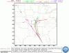
Looks like Memphis is going to get it as well. Hope my sister decides to visit my parents in Wisconsin.
 
Yes, YNCS, Memphis is already under a flood watch, which would be the darker blue colour:
 

Attachments

  • Dennis17.jpg
    Dennis17.jpg
    34.9 KB · Views: 47
Dennis photo from Guantanamo, Cuba:
 

Attachments

  • dennis18.JPG
    dennis18.JPG
    38.2 KB · Views: 48
Back
Top Bottom