Hurricane Dennis

I was south of Tampa Bay for Hurricane Charlie, and let me say it was not fun. Instead of going to a shelter, my family, hurricane newbies, stayed on our condo (on the second floor) out on a strip island. Luckily, that was a smart move, as the hurricane passed right below us.
 
Not Category 5... It never got there. It's over Cuba now and has briefly dropped to 135 mph winds. Once it crosses Cuba it will almost certainly restrengthen to 150 mph winds and eventually to the earliest Category 5 hurricane recorded (and the only one ever in July).
 
Not likely... It's already more than halfway across Cuba and conditions are very favorable for it to restrengthen. It may only be Category 4, but I doubt that it will make landfall as anything less than that.
 
The latest radar from Cuba:
 

Attachments

  • cienfuegosa.gif
    cienfuegosa.gif
    114.7 KB · Views: 94
Enhanced infra-red satellite photo. Bottom-right of picture, is Dennis over Cuba.
 

Attachments

  • dennis7.jpg
    dennis7.jpg
    96.8 KB · Views: 102
wow.......i had to leave FL earlt because of that stupid hurricane
 
This is getting scary.... :eek:

There's actually a mandatory evacuation here, but we ain't leavin'!
 
Radar loop of south Florida and Cuba, showing Dennis exiting the Cuban coast. It appears to have moved very close, or over Havana...
 

Attachments

  • dennis8.gif
    dennis8.gif
    385.9 KB · Views: 75
Weather Channel's website says it dropped to Category 2, although that fails to cheer me up.
 
Smellincoffee, this was expected. Dennis moved over the rugged terrain of Cuba. But now it is back over warm water, and has re-intensified to a category 3 hurricane. Here is the latest discussion bulletin from the NHC:

HURRICANE DENNIS SPECIAL DISCUSSION NUMBER 22
NWS TPC/NATIONAL HURRICANE CENTER MIAMI FL
7 PM EDT SAT JUL 09 2005

WHAT A DIFFERENCE 2 HOURS MAKES! AIR FORCE AND NOAA HURRICANE
HUNTER AIRCRAFT INDICATE THE CENTRAL PRESSURE OF DENNIS DROPPED 11
MB IN AN HOUR AND A HALF. THE MAXIMUM FLIGHT-LEVEL WINDS REPORTED
N OF THE CENTER WERE 105 KT...AND THERE WERE LIKELY STRONGER WINDS
IN THE NORTHEASTERN QUADRANT THAT THE AIRCRAFT DID NOT SAMPLE.
THIS SPECIAL ADVISORY UPGRADES DENNIS TO A 100 KT CATEGORY 3
HURRICANE BASED ON THE AIRCRAFT DATA.

THE TRACK FORECAST IS UNCHANGED FROM THE PREVIOUS PACKAGE. IT IS
UNCLEAR HOW LONG THE CURRENT INTENSIFICATION WILL CONTINUE...BUT
THE INTENSITY FORECAST IS REVISED TO SHOW 12 HR OF RAPID
STRENGTHENING FOLLOWED BY SLOWER STRENGTHENING UNTIL LANDFALL. THE NEW INTENSITY FORECAST BRINGS DENNIS ASHORE AS A CATEGORY 4 HURRICANE. AFTER-LANDFALL INTENSITIES WERE ALSO INCREASED THROUGH 72 HR TO REFLECT THE INCREASED LANDFALL INTENSITY.

THE NEW PACKAGE ALSO INCLUDES SLIGHT REVISIONS TO THE WIND RADII AND 12 FT SEAS RADII.

FORECASTER BEVEN

FORECAST POSITIONS AND MAX WINDS

INITIAL 09/2300Z 26.1N 84.9W 100 KT
12HR VT 10/0600Z 27.5N 85.8W 115 KT
24HR VT 10/1800Z 29.9N 87.2W 120 KT
36HR VT 11/0600Z 32.3N 88.4W 75 KT...INLAND
48HR VT 11/1800Z 34.2N 89.3W 35 KT...INLAND
72HR VT 12/1800Z 37.0N 89.0W 25 KT...INLAND DISSIPATING
96HR VT 13/1800Z 38.0N 87.0W 20 KT...INLAND REMNANT LOW
120HR VT 14/1800Z 39.0N 82.0W 20 KT...INLAND REMNANT LOW

----------------------------------------
Here is the latest radar from Tampa Florida. Can you make out the eye?
 

Attachments

  • dennis9.JPG
    dennis9.JPG
    108.4 KB · Views: 61
Well, Narz, the eye of Dennis is almost due west of you:
 

Attachments

  • dennis10.jpg
    dennis10.jpg
    37.8 KB · Views: 54
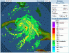
By the way, for those of you further inland.... Dennis is expected to move slowly, due to running into a high-pressure ridge. Places as far inland as Tennessee, Kentucky, eastern Missouri, etc., could get flooding rains from Dennis, early next week. Here is a computer forecast chart predicting the remnants of Dennis over Memphis Monday evening, with heavy rains (the dark reds) into parts Missouri, Arkansas, and even up towards Cairo Illinois:
 

Attachments

  • dennis11.JPG
    dennis11.JPG
    93 KB · Views: 45
By the way, that was the NGP model. The GFS model has the remnants of Dennis a little further east by Monday evening, and with heavier rainfall. The bright purple or magenta colour over Tennessee indicates rainfall of 70mm in the previous 12 hours. Since 25.4mm = 1" of rainfall, this predicts 3 inches of rain. However, such models notoriously under-estimate rainfall from tropical systems. I think Dennis may be a big story for days after landfall, due to flooding... :(

Here is the GFS:
 

Attachments

  • Dennis12.JPG
    Dennis12.JPG
    96.5 KB · Views: 65
cool maps quasar thanks! :goodjob:
 
This chart is from Channel 8, in Tampa, Florida. The 4 in the center of the hurricane symbol, shows that Dennis is expected to make landfall as a category 4 storm. Note the 2 a.m. Monday position near Meridian, Mississippi forecasts Dennis to have maximum sustained winds of 85 m.p.h., which would still be hurricane strength...
 

Attachments

  • dennis13.JPG
    dennis13.JPG
    28.9 KB · Views: 46
Back
Top Bottom