Hurricane Isabel

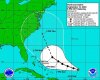
The different computer models roughly agree for the next 2 days, then begin to diverge. Here is a plot of the tropical model predictions:
AL1303TRP.JPG

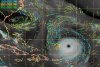
Some models are global in scale, but are still useful for forecasting tropical systems. For instance, JMA stands for the Japanese Meteorological Agency, which runs a very good global model. Here is a plot of the major global model predictions:
AL1303GLB.JPG

The hurricane center now must decide which model is doing the best job, and which one WILL do the best job, at handling Isabel!
 
I can't see the pictures :(
 
Much appreciation. I'm living in Orlando and didn't hear anything of this. I'll definately watch this.
 
Originally posted by The Yankee


Ah, yes, Hurricane/Tropical Storm Floyd in '99. Got rid of school after I already left the house....so I was pretty soaked.

I also remember a Hurricane Bob making it up to NYC in the early '90s.


As for Isabel...it's now a Category 5...looking like it's aiming for the Bahamas.
i just liek to clarify, that i, farting bob, did not cause hurricane bob.
and im sorry, but i cannot take a hurricane called isabel seriously.
"oh no, isabel has unleashed her amazign power!, ill have to stop her takign over my cities after the hurricane has past"
and also, on them maps of different met companies, i wouldnt go for JMA, it starts about 100 miles south of the actual cource it's already taken. asif it stops, moves south and starts again.
 
Originally posted by farting bob
also, on them maps of different met companies, i wouldnt go for JMA, it starts about 100 miles south of the actual cource it's already taken. asif it stops, moves south and starts again.
Actually, Bob, you have a point. Meteorologists look at how well a computer model initializes; that is, does it have the features in the right place, at the right strength, at the beginning of the model run? But you can't throw out the forecast track from the JMA just because it doesn't initialize as well as others.

Yes, Isabel is back to being a category 5 hurricane. She went through an "eyewall replacement cycle", which caused some temporary weakening. Isabel should not lose much strength over the next 72 hours. Beyond that, the NHC has Isabel dropping to a category 3 storm.

Below is an infrared satellite photo of Isabel at 13/2045Z Sep. When the hurricane hunters reported their measurements back to the NHC, they included the remark, "Nice stadium effect". The stadium effect is when the cloud mass surrounds the eye, with towers of clouds up to 50,000 feet, and a clear sky above. This phenomena looks like a huge sports stadium!
20.jpg


It's looking better for Florida to escape this storm, but worse for North Carolina. Still, there is a chance Isabel will recurve out to sea before striking land. Isabel needs to start moving more NW than WNW soon, or else it will have to make a drastic change in direction to miss the coast. Right now its motion is towards 285 degrees at 12 mph. Here is the latest forecast track:
 

Attachments

  • izbel13_5pm.jpg
    izbel13_5pm.jpg
    69.7 KB · Views: 103
Toying with us, eh? I feel sorry for the guys on the coast now. It'll be bad enough when (if) it gets here. (western NC)
 
thats a illuminated nipple in your last post Quasar :lol:
 
When looking for steering currents for hurricanes, we look at the mid and upper-level windflow ahead of the storm. I have posted a satellite photograph with mid and upper-level windbarbs shown. If you look off the coast of South Carolina, you can see a mid-level low. This is actually associated with the remnants of tropical storm Henri. Isabel has about another 48 hours of forward motion before she will begin to be affected by the remnants of Henri. Of course, the low near South Carolina is moving away too. But it should exert enough of an influence on Isabel to begin turning it more towards the NW.

For Isabel to turn north, there is another feature, a shortwave trof, that will approach from the U.S. mainland next week. This may be the key in turning Isabel away from the coast. But it is too early to tell how strong the trof will be, and how far north Isabel will be by then.

One last danger is that some models have Isabel stalling out for a short period in about 60 hours. We'll have to see if this actually occurs or not.

Here is the chart:
 

Attachments

  • wg8wvirz.jpg
    wg8wvirz.jpg
    80.9 KB · Views: 249
Originally posted by farting bob
thats a illuminated nipple in your last post Quasar :lol:

What a way to go! Crushed by a giant Category 5 illuminated nipple!
 
Say for the sake of argument that Isabel hits the NC coast. What would it do then? Head further inland? Bounce off into the Atlantic, or perhaps head up into Chesapeake? How far away from the center would the affected area radiate? About how long would the hurricane last?

I'm still clueless as to why the hurricane manages to retain its coherence and doesn't just spin itself out of existence, but then I'm no meteorologist ;)
 
Originally posted by Pontiuth Pilate

I'm still clueless as to why the hurricane manages to retain its coherence and doesn't just spin itself out of existence, but then I'm no meteorologist ;)

Im not a meteoroligist either but I like making believe I know everything so heres an explanation: A hurricane is like an engine. The fuel of the engine is heat, as soon as it runs out of heat it runs out of gas and then it does spin out of existence.
 
Originally posted by Pontiuth Pilate
Say for the sake of argument that Isabel hits the NC coast. What would it do then? Head further inland? Bounce off into the Atlantic, or perhaps head up into Chesapeake? How far away from the center would the affected area radiate? About how long would the hurricane last?

I'm no meteorologist either, but this is based on memory of past examples. If it hits NC, it'll probably hit wilmington. For some reason 'canes are just attracted to it. It'll most likely continue west and slightly north through the state, probably burning out as a hurricane by the time it leaves NC. Keep moving roughly NW until it burns out.

It should give us some nice flooding to, since the ground is saturated in most places due to record rainfall. (55" so far this year, normally we get ~30-35" in an entire year)
 
across the pond in england, we're on cource for he hottest year in 250 years and the dryest in about 100.
 
Speedo's right, the last thing we need in NC is more rain, but I used to have grandparents in Wilmington and he's right, that city gets smacked down a lot by 'canes.

Is it just me or do the Outer Banks act as a somewhat (not always) resistant magnet to hurricanes? If we're lucky something will turn it north. It would be far preferable to see it parallel the coast and weaken before crossing onto land. Heavy rain for 80 million people up and coast would be much more ideal than seeing a localized spot of several million have to evacuate and then return home to several counties smacked down by a direct touchdown.
 
My wife was just off the path of a T5 tornado a few years ago (we have pictures). This thing is even scarier. What a monster.

J
 
Originally posted by onejayhawk
My wife was just off the path of a T5 tornado a few years ago (we have pictures). This thing is even scarier. What a monster.

Yikes. I'd be fine without either. At least you can effectively run from a twister. I've only been through one of those, and it couldn't have been more than a T1. More than enough for me.
 
It seems like it's getting more and more likely to head right up the bay. I've got a friend down in Salisbury(which is down near the mouth, on the peninsula side) and he's saying there's probably a good chance that they're gonna get "slammed"
 
Back
Top Bottom