Hurricane Isabel

Been busy today, but here is the latest forecast track from the NHC. I think the mid-Atlantic could be in for a rough time. If Isabel does take this track, the center of the storm would pass over Norfolk VA and Washington DC. Baltimore could also be severely affected. If Isabel were to make landfall, there would be tornadoes and flash flooding as well as the storm surge and hurricane force winds. The next 24 hours will be crucial, for the 2 upper-level steering features that are expected to pick up Isabel and turn her northward, will begin to affect her later on Monday. Time will tell.
 

Attachments

  • izbel14_11pm.gif
    izbel14_11pm.gif
    38.9 KB · Views: 654
HURRICANE ISABEL DISCUSSION NUMBER 38
NWS TPC/NATIONAL HURRICANE CENTER MIAMI FL
11 AM EDT MON SEP 15 2003

SATELLITE IMAGERY INDICATES THAT THE INNER CORE STRUCTURE CONTINUES TO BREAK DOWN...WITH A LESS WELL-DEFINED EYE IN VISIBLE IMAGERY. EYEWALL CONVECTION HAS BECOME ASYMMETRIC AND FRAGMENTED...AND THE
OVERALL CONVECTIVE STRUCTURE IS NOW MORE BANDED THAN IT WAS OVER THE PAST COUPLE OF DAYS. THE LATEST DVORAK SATELLITE INTENSITY ESTIMATES ARE 115 KT. THE ADVISORY INTENSITY IS LOWERED TO 120 KT AND ANOTHER RECONNAISSANCE AIRCRAFT WILL BE IN THE HURRICANE AT
18Z.

THE INITIAL MOTION IS 300/7...SLOWER THAN BEFORE. WITH THE
MID-LEVEL SHORT WAVE OFF THE CAROLINAS MOVING OUT TO THE
NORTHEAST...THE STEERING CURRENTS SURROUNDING ISABEL ARE BEGINNING TO WEAKEN AS SOME RIDGING TEMPORARILY BUILDS IN NORTHWEST...AHEAD OF...THE HURRICANE. THIS SHOULD RESULT IN A SLOW MOTION TO THE NORTHWEST OVER THE NEXT DAY OR TWO. BY 48 HOURS OR SO...AN
APPROACHING TROUGH FROM THE WEST WILL HELP ACCELERATE ISABEL NORTH-NORTHWESTWARD AROUND THE WEST SIDE OF THE DEEP-LAYER RIDGE ANCHORED NEAR 35N AND 60 W. MODEL GUIDANCE IS IN EXCELLENT AGREEMENT ON THIS TRACK ALTHOUGH THE GFS IS CONSIDERABLY SLOWER THAN THE OTHER MODELS. VERY LITTLE CHANGE HAS BEEN MADE TO THE
OFFICIAL FORECAST TRACK...WHICH IS VERY CLOSE TO THE GFDL...UKMET...NOGAPS...GFS MODEL CONSENSUS.

ALTHOUGH THERE HAS BEEN SOME RESTRICTION OF THE OUTFLOW IN THE SOUTHWEST QUADRANT...THE CURRENT WEAKENING MAY BE MORE A RESULT OF LESS FAVORABLE ENVIRONMENTAL THERMODYNAMICS. THERE ARE WESTERLIES
TO THE NORTH OF ISABEL...BUT THE SHEAR IS EXPECTED TO BE LIGHT FOR THE NEXT 36 HOURS OR SO. THERE WILL BE PLENTY OF WARM WATER UNDER THE HURRICANE UNTIL COOLER SHELF WATERS ARE ENCOUNTERED RIGHT ALONG THE COASTLINE. ONE KEY TO THE ULTIMATE LANDFALL INTENSITY WILL BE THE EVOLUTION OF AN UPPER-LEVEL TROUGH THAT COULD ENHANCE
THE OUTFLOW AND REDUCE THE SHEAR PRIOR TO LANDFALL IF IT DIGS AS SHARPLY AS FORECAST BY THE GFS. WITH THIS IN MIND...ISABEL COULD STILL BE A MAJOR HURRICANE AT LANDFALL.

FORECASTER FRANKLIN

FORECAST POSITIONS AND MAX WINDS

INITIAL 15/1500Z 25.2N 69.4W 120 KT
12HR VT 16/0000Z 25.8N 70.3W 115 KT
24HR VT 16/1200Z 27.0N 71.2W 115 KT
36HR VT 17/0000Z 28.2N 72.0W 115 KT
48HR VT 17/1200Z 30.0N 73.0W 115 KT
72HR VT 18/1200Z 34.5N 75.5W 110 KT
96HR VT 19/1200Z 40.0N 78.0W 60 KT...INLAND
120HR VT 20/1200Z 49.5N 80.0W 30 KT...EXTRATROPICAL
 
Here is a different view of the official forecast track from the National Hurricane Center. This view lists the projected wind speeds, in knots. Note the legend in the bottom left corner. The red areas are where 64 knot winds are expected at the valid time of the forecast path ; 64 knots and greater is hurricane strength. The yellow areas are where tropical storm force winds are expected.

13L.gif


Remember that this is a forecast, and is based largely on computer models. Here is what the tropical models are predicting for a path for Isabel:

iz915trp.gif


The global models are suggesting this:

iz15glb.gif


Remember that the hurricane will spread its effects over areas not affected directly by the center. If it makes landfall as forecast, Isabel will be a major rain producer for the mid-Atlantic coast. Hopefully it will move quckly and not have time to produce excessive rains over any one area. Stay tuned!
 
If Isabel moves inland, it is projected to reach the Appalachian Mountains. The moisture from Isabel will be lifted orographically. This will cause even heavier rains than would occur over flat land.
Hurricane Camille in 1969, and Hurricane Agnes in 1972, caused great damage by flooding; this was mostly from orographic lift. Fortunately, Isabel is forecast to be moving fast enough that the flooding should be limited. But there will likely be at least some flash flooding. This is the area that could be under the gun:
 

Attachments

  • flood.jpg
    flood.jpg
    35.1 KB · Views: 112
Hunt Valley MD is a suburb of Baltimore. So yes, Baltimore could be badly affected.

At least Isabel is down to a category 3 now. But the NHC says it should maintain its strength from now until landfall. Anything category 3 and above is considered a "major hurricane".
 
Looks like it will miss New York but hit my summer house.

I'm happy. My cross country coach told me we would practice in the hurricane as long as there weren't dangerous wins. The bastard!
 
Originally posted by Jonny11788
Isabel's now a Category 5 again:

I sure am glad I'm not living on the Atlantic coast right now...

Yes well I do. Just to clarify things here is there even the remotest chance this thing could hit Maine.
 
Originally posted by cgannon64
Looks like it will miss New York but hit my summer house.

Yes, but what about the rain once it moves inland? Upstate New York stands to get pretty wet from the remnants of Isabel.

Maine may be too far east to get much rain from it, but Isabel could still recurve further east than expected.
 
I just read that there is an evacuation warning for the US coast, i will let our friend tell us more about it.
 
I am realy proud of our meteorologist-computer assisted. They were able to anticipate this hurricane's path and thus preventing casuality. Thanks too Allah or God or Yanhve or Shiva or the Sacred Bear of Abenakee to allow us preventing this ''human made increased device of mobil home mass destruction";)
 
Note: This forecast is unofficial, and is NOT from the National Hurricane Center. See our disclaimer.
After weakening some overnight, Isabel is definately holding its own this afternoon. Upper level outflow is outstanding to the east, but not quite as impressive in the other quadrants. Nonetheless, water vapor imagery shows the outflow is still improving, mainly to the north with the shortwave trough in an aiding position. Earlier in the day, there was quite a bit of dry air entrainment in the center from the southwest, which kept it partially opened. Since then, convection has wrapped around the entire center, and the small pockets of dry air within the convection have dissapeared. Along with more wrapping, the convection itself is a lot less ragged, though is showing no signs of deepening yet. Data from a reconassiance aircraft reflect on Isabel's improving organization, but found that the maximum sustained winds remain near 90 knots.

Additional strengthening is expected. SHIPS now shows some slight intensification, a bit of a change from its past runs in calling for weakening. The majority of the global models indicate that the shear pattern will set up to favor even better outflow in all quadrants, which would in turn lead to strengthening provided the core is fully recovered. Earlier in the day I would have been skeptical on whether Isabel's core would recover or not, but the question is irrelavant. As mentioned above, convection is now blossoming over Isabel's center, a sure sign of core recovery. This will allow the expected improved outflow pattern to influence Isabel's intensity. Additionally, Hurricane Heat Potential is higher ahead of Isabel, which also favors deepening. Sea surface temperatures are plenty warm except right off the east coast, where Isabel will move in the coming two days. I do not expect these cooler temperatures to play a major role in Isabel's intensity simply because their overall coverage is small, and since Isabel will be speeding by the time it passes over, the time spent over them is reduced even more. Based on the current organization, heat potential, and anticipated shear pattern, strengthening back to a category 3 hurricane is in the forecast.

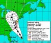
The future track of Isabel is becoming clearer. Nearly all of the global and tropical models are converged on a continued motion to the north-northwest through the next 24 hours or so, followed by a bend more to the northwest afterwards. Isabel is being influenced by a shortwave trough, but an area of high pressure is already building to the north, which will prevent a turn out to sea. This high pressure is actually what will curve Isabel to the northwest as it makes landfall. Based on model guidance and the current synoptic pattern, a landfall near Morehead City, North Carolina is expected. From there, a track through the northeastern part of the state, probably midway between Rocky Mount and Raleigh. From there, Isabel will weaken rapidly into a remnant extratropical low as it moves through central Virginia and up further north.

All residents living along the North Carolina coastline should have already evacuated or prepared for Isabel. Stay tuned to local weather statements from complete safety precautions.

Forecast Intensity:
00 hours: 90 knots
12 hours: 95 knots
24 hours: 100 knots
36 hours: 105 knots
48 hours: 105 knots (approaching land)
72 hours: 30 knots (inland)
96 hours: 30 (inland and extratropical)
120 hours: (absorbed by low)

Forecast Track
 
Here is the latest forecast tracking chart for Hurricane Isabel, now a category 2 storm:
 

Attachments

  • isabel16_5pm.jpg
    isabel16_5pm.jpg
    79 KB · Views: 74
Ugh. Looks like its going to miss NYC.

Hopefully we'll get alot of rain or something so I can still miss school.

EDIT: Isn't this a very odd path for a hurricane? I mean, its going to hit Pennsylvania! Granted, it will be small then, but still, Pennsylvania...
 
I got the feeling NYC public schools won't be closed unless it's still a fairly strong tropical storm. I mean, for Floyd, they hesitated so long to close shop that many people wound up going anyway, only to be turned back and left outside, not even let inside to gather their thoughts, look at bus/subway schedules, make a call.
 
Why would Isabel be speeding up as she goes over land??? [according to your map] Wouldn't land and its different elevations slow her down?
 
Back
Top Bottom