Quasar1011
King of Sylvania
From the Weather Channel website:
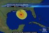
As of 2 a.m. CDT, Katrina has been downgraded to a strong Category 4 hurricane with top winds of 155 mph. Much of the western half of Katrina has degraded as dry air has been drawn into the cyclone allowing weakening to occur. Although Katrina has been downgraded, it remains a strong and dangerous hurricane. Katrina is a large hurricane with hurricane-force winds extending 105 miles from the center and tropical storm-force winds extending up to 230 miles from the center. Movement is now northward and a turn towards the north-northeast is expected tonight.
As of 2 a.m. CDT, Katrina has been downgraded to a strong Category 4 hurricane with top winds of 155 mph. Much of the western half of Katrina has degraded as dry air has been drawn into the cyclone allowing weakening to occur. Although Katrina has been downgraded, it remains a strong and dangerous hurricane. Katrina is a large hurricane with hurricane-force winds extending 105 miles from the center and tropical storm-force winds extending up to 230 miles from the center. Movement is now northward and a turn towards the north-northeast is expected tonight.
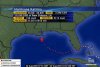
 . So, here is the storm surge forecast map:


")