Issue with communitas map generation:

dostillevi

Prince
Joined
Sep 16, 2009
Messages
309
I've played several games now where the predominant shape of the game's landmasses are Xs with diamonds in between:

upload_2019-6-19_14-53-6.png


I've run into this using the default Communitas map as well as the updated map from the "How do I get a start like this" thread (shown in screenshot above): https://forums.civfanatics.com/threads/how-do-i-get-a-start-like-this.645642/page-2

These are my typical settings:

upload_2019-6-19_14-56-26.png


Sometimes I play with sea level normal and resources sparse. Any ideas? I'd really like some more variety.
 
A few more tests with the default Huge settings:

Default settings:
upload_2019-6-19_15-5-37.png


Test 1:
upload_2019-6-19_15-8-34.png


Hints of the X issue, particularly on the left continent, the diamond shape of the islands split at the map edges, and the X of the right continent is visible but not centered vertically.

Test 2:
upload_2019-6-19_15-11-44.png


Same as Test 1, with the right continent X centered lower on the map. The Rifts and island placement are very consistent and the overall continent shape is very similar, even if the details vary from map to map.

Test 3:
upload_2019-6-19_15-15-41.png


Exactly the same patterns emerge.
 

Attachments

  • upload_2019-6-19_15-6-51.png
    upload_2019-6-19_15-6-51.png
    79.1 KB · Views: 332
Overall I get the feeling that the issue is in the nature of the ocean rifts setup. I did another test with rifts disabled and got this fantastic map:

upload_2019-6-19_15-21-42.png


I'm satisfied with this solution, but I'd suggest improving rift generation to avoid the predictability of maps with rifts turned on.
 
I am having a different issue. If i set the continents to ONE, rifts to zero, seas to low, I get a map like the ones you are getting. This does not seem like the expected result.
 
How many players and city states do you have in your testing?
 
I typically play with 12-15 civilizations and 24-32 city-states. The map script doesn't alter rift placement based on civ count, but resources and hills are added as needed to balance starts.

I've tried tweaking the map script quite a bit and I'm narrowing down what I'm looking for to a few things:

Without using rifts (they look like they need a major re-write to address my concerns with them):
1. Increase the amount of trees and especially jungle on the map. -Done
2. Reduce the visible banding of trees and terrain types at transitional latitudes a bit, so there's more variability around the 3 or so tiles north and south of the latitudes where tile types transition. This is basically de-prioritizing latitude while emphasizing "weather". -Done
3. Reduce the number of 1-3 tile islands in what would otherwise be ocean by about 25% (mostly to decrease the amount of navigable waterways prior to ocean travel. -Major task

Reading over the map script, I don't see anything that appears to control for 1-3 tile islands. Rifts are a relatively easy way to hack the map to create ocean divides, but I'd hope to push the map towards a slightly more elegant solution. What I'm looking for is something akin to Indonesia (multiple 1-3 tile islands connected by coastal waters to each other and to a larger land mass in 1-3 places on the map, with other 1-3 tile islands scattered with ocean between them and major land masses. The intention is to limit early exploration off the starting continent.

Step one would be to simply remove land tiles from islands that share shallow water with a continent, until X% of islands are not connected to continents. Step two would be to identify archipelagos that still have a coastal connection to a continent and buff them a bit with additional land tiles and islands, but in such a way that the archipelago only connects to one continent by coastal waters. An Archipelago connecting two continents would have the island tiles remove from close to one continent until that coastal connection is removed.

I read the entire Communitas .lua this afternoon and made a few changes which I'm attaching:

-Increased tropicLatitudes from 22 to 27 gives more room for both deserts and jungle.
-Increased horseLatitudes from 23 to 19 gives more room for plains. The idea with these two is that some overlap might generate more variance around the latitude transitions. I'm not sure if it worked exactly, but the result seems good.
-Reduced landMaxScatter from 0.06 to 0.04 in an effort to reduce islands. This is one change I'm not fully set on, but the results are generally ok if not very effective at reducing islands.
-Reduced coastScatter from 0.09 to 0.05 for the same reasons landMaxScatter was reduced.
-Reduced BelowMountainPercent from 0.94 to 0.92 for slightly more mountains.
-Reduced hillsBlendPercent from 0.45 to 0.35 to compensate for having more mountains on the map.
-Increased featurePercent from 0.60 to 0.75 in order to add more jungle and forest in general within the allowed areas.
-Reduced zeroTreesPercent from 0.35 to 0.20 to allow for more trees in general
-Reduced plainsPercent from 0.50 to 0.40.
-Reduced desertPercent from 0.67 to 0.60 to allow more room for jungle (jungle doesn't like being near desert).
-Reduced riverPercent from 0.25 to 0.23 to remove some of the one-tile rivers that are very common along the edges of continents. Might reduce this further to 0.22 but it seems to be very sensitive.
-Increased riverRainCheatFactor from 1.25 to 1.45. This apparently increases watershed area, and I was happy with the resulting longer rivers. Adjust this up to 1.65 if riverPercent is adjusted down to 0.22.
-Increased geostrophicFactor from 3.0 to 5.0 to increase the impact of weather (monsoon climate) over latitude. I think this had a big impact, and I haven't yet tried values other than 5.

This map is intended to be used without rifts. I played around with rift values and decided some more significant work is needed if they're to be very good. Specifically, I'd want to add vertical variance in the sin calculation for the Atlantic rift, rotational variance for both rifts, and the option to specify different widths at the "top" and "bottom" of each rift. These changes require more research, and I'd prefer the archipelago solution outlined above instead.

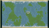
Here are some screenshots of a sample map:

Overall there are large landmasses but not enough separation between continents.

upload_2019-6-19_23-23-16.png


Continents have large deserts as well as thriving forests and jungles:
upload_2019-6-19_23-23-25.png


The elongated river watersheds create distinct geographical areas:

upload_2019-6-19_23-24-32.png


Notice the very wet area near my spawn, with many rivers, jungle, and marshes filling up this desirable area:

upload_2019-6-19_23-26-38.png


I recommend playing this map script with no more than 14 civs and 28 nation-states on Huge. I play with the City-States Evolved mod though, so you might be able to increase the nation state count slightly without it.

Editing to add that my changes do go against the original intent of this map, which is to create an Earth analog. My map has wider ranges for jungle and technically there should be a lower percent of land than this map has. It's also much wetter than Earth imo.
 

Attachments

Last edited:
And if you disable the rifts, then you can circumnavigate the world in ancient era, because all the continents are clumped together.

I never had the patience to run enough tests, but I think when you increase the number of civs you start getting these weird long 1-tile wide "rivers" separating the land masses I can also see on several of your screenshots. If you increase them even more, then the "rivers" straighten up and form long straight lines.

Edit: This was refering to the initial posts, not the updated version.
 
Last edited:
Wow, @dostillevi, this is a huge improvent!!! Do you think you would also manage to separate the main land masses a bit more to make them reachable only after discovering Caravels?

Otherwise, it seems that you are addressing most of the reasons why I stopped using this map script long time ago. I will give it a spin with your version.

Thank you very much for working on this!
 
And if you disable the rifts, then you can circumnavigate the world in ancient era, because all the continents are clumped together.

Do you think you would also manage to separate the main land masses a bit more to make them reachable only after discovering Caravels?

I'll take a look at them again when I have time. Early circumnavigation and early meeting of civs on other continents is pretty undesirable. This is a much bigger fix though so it'll take more time. I tried adjusting the more accessible rift settings without much satisfaction. You certainly can play this version with rifts on, but the continents won't be as varied since the rifts are set to always appear in the center of the map (Atlantic S) and on the edges (Pacific diamond), preventing the formation of continents that are wider than about 40% of the map. Maybe try using the "1 random" rift option? Not a perfect fix though, and I generally prefer the pacific rift to the Atlantic.

How to use this map? I have placed coomunitas (unpacked) folder in MODS folder. Is that it?

1. Download and unzip the map script.
2. Locate (Documents)>My Games>Sid Meier's Civilization 5>MODS>(1) Community Patch>Mapscripts and save a copy of the original Communitas.lua somewhere else like your desktop.
3. Copy the new communitas.lua from the zip file into this folder, overwriting the original.

Note that reinstalling or updating Vox Populi will override my version of the map script, so remember to redo this after each update.
 
Last edited:
Can i put this in maps folder on the root directory of game and play vanilla too? Not the vp mod folder.
 
Put the .lua file in Documents\My Games\Sid Meier's Civilization 5\Maps, then you don't have to load any mods.
 
@dostillevi - Could you put up a screenshot of your current game options, whats the intended setting for Ocean Rifts, Rifts Width and Sea Level? None, Normal and Medium?
 
Last edited:
This map is intended to be used without rifts.

I'm playing on Large with 10 civs and 20 city states, and feel like there is kinda too much space for the player to expand into (like enough for me to found 8~10 cities in general).
Should I play with more civs and city states on Large?
 
I'am not sure about large maps but I'am going with 15 civs 24 states huge, Its early on and things seem fine, I want it to be cramped to incite more wars. I'd probaly go with 12 civs 20-22 states large for your 8-10 cities.
 
Thanks, will try that out.
At this point UU seems useless because there is no war at all like until Renaissance Era.
 
Large on most maps has 50% more land, so if you want to keep the same amount of space per civ, there should be 12 civs and 24 CS.
 
Still kinda feel game is too easy with too much "free space" even with 12 civs and 24 CS, will try 14 civs and 28 CS on Large.

At this point, I think I'm beginning to understand why the latest original Communitas map went in "that" direction (civs extremely close to each other with some entirely unoccupied continents elsewhere).
 
Thanks for the feedback everyone! I haven't changed the land area from the base mod, and I agree at the civ recommended civilization and city state counts there is too much land. I recommend the following:

1. Increase the number of civilizations by 2-4 over what you normally play on your map size.
2. Increase the number of city states by about 20%-30%.

Adjust the ocean level if you like, but all this does is increase or decrease the percent of the map that is land. Raising sea levels is one way to reduce land size, but then there will be even more ocean to compensate. I want to find a better solution for separating continents before playing around more with land ratios.

If you don't mind opening the .lua file in a text editor, the land/water ratio is one of the first options. Try decreasing it by 5%-7% and see if that meets your needs.

Also I play with and highly recommend City States Evolved, which allows every city state to expand to several cities, one per era. This makes city states more relevant, allows more free movement (you can move through their territory at any era with a small diplo penalty), gives more non-civ targets for warmongers/early capture, and they also occupy more of the map.
 
Last edited:
Back
Top Bottom