You are using an out of date browser. It may not display this or other websites correctly.
You should upgrade or use an alternative browser.
You should upgrade or use an alternative browser.
Map creating offer
- Thread starter LouLong
- Start date
LouLong
In love with Rei Ayanami
Yep, good point. If it had been for scenarios I would disagree but since we can't make real scenarios I guess it is better to focus on 6000 years ago (although in that case, wine would not show so much).
BTW sorry you did not respond earler to the Baltic preview. I had just uploaded it when I saw your mail.
I wished I had made a coastal link between Aland islands and Finland. Maybe I will correct it.
I still love ur signature
BTW sorry you did not respond earler to the Baltic preview. I had just uploaded it when I saw your mail.
I wished I had made a coastal link between Aland islands and Finland. Maybe I will correct it.
I still love ur signature
Procifica
ACW Scenario Creator
Originally posted by LouLong
Procifica, in that case just go to the Map creating offer thread. Use the link I provided to get a precise photo of what you would like.
But it is down the list, first I need to finsih Grand Greece, Italy and Black sea.
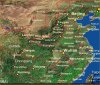
Ok I will do so. I'm mainly looking for a map of most of China, except northern most Manchuria and the western and southern most slices.
Procifica
ACW Scenario Creator
I think this is about what I need. I don't need Taiwan (Formosa).
Size...I'm thinking 140 X 140 would probably work. If you need to adjust it slightly either way to make its latitude/longitude stuff accurate, then please do.")
If you could, I also need the Yanghtze (however you spell it) and Huang Ho rivers navigable (meaning, using coast squares to make them). Thanks in advance.
Size...I'm thinking 140 X 140 would probably work. If you need to adjust it slightly either way to make its latitude/longitude stuff accurate, then please do.
If you could, I also need the Yanghtze (however you spell it) and Huang Ho rivers navigable (meaning, using coast squares to make them). Thanks in advance.
Attachments
LouLong
In love with Rei Ayanami
Originally posted by Procifica
I think this is about what I need. I don't need Taiwan (Formosa).
Size...I'm thinking 140 X 140 would probably work. If you need to adjust it slightly either way to make its latitude/longitude stuff accurate, then please do.
If you could, I also need the Yanghtze (however you spell it) and Huang Ho rivers navigable (meaning, using coast squares to make them). Thanks in advance.
Thanks for the precision.
I agree about the rivers being navigable though the Huang He (northern one) is not famous for that. What about the canal ont the other hand (I have to check if it was built at that time).
Otherwise, are ou sure you wanna get a 140 x 140 map. There is very little sea so that would make huge terrain...
Yoda Power
✫✫✫✫✫✫✫
- Joined
- Sep 24, 2002
- Messages
- 13,870
i have been lurking for a while on this china scenario project, and i think that a standard map would be enough.
Procifica
ACW Scenario Creator
Yoda Power is probably right, standard might be better. Basically what I want to do, is divide China into roughly 50 or so provinces, of various size (largest maybe 3 times the size of the smallest), and each capital city (in theory in the center) being about 5 to 6 squares away minimum from any other. The 50 capital cities is what I will have on the map.
So how about 120 X 120? I want to make sure its big enough for what I want. Too small would be counter-productive, if its a little too big I can live with it. I don't want you to do it twice. If 120 X 120 though is too big for you, then 100 X 100 should work.
I think a famous naval battle was fought on the Huang Ho river though...it wouldn't have to be navigable all the way through its course, just the part that lies in eastern china.
So how about 120 X 120? I want to make sure its big enough for what I want. Too small would be counter-productive, if its a little too big I can live with it. I don't want you to do it twice.
If 120 X 120 though is too big for you, then 100 X 100 should work.I think a famous naval battle was fought on the Huang Ho river though...it wouldn't have to be navigable all the way through its course, just the part that lies in eastern china.
LouLong
In love with Rei Ayanami
Tropical Africa map first version to be ready very soon, I just need
to finish Madagascar. Maybe tonight.
After that my two next projects are a "good" map of France and the map of China for Procifica (I will try to start with a 100 x 100).
At the same time I am trying to improve the Baltic map for I am not so happy with the terrain.
to finish Madagascar. Maybe tonight.
After that my two next projects are a "good" map of France and the map of China for Procifica (I will try to start with a 100 x 100).
At the same time I am trying to improve the Baltic map for I am not so happy with the terrain.
LouLong
In love with Rei Ayanami
Tropical Africa map beta uploaded.
Any feedback Kinboat ?
Ready to create colonization scenarios or French paratroopers dropping on Kolwezi ?
Any feedback Kinboat ?
Ready to create colonization scenarios or French paratroopers dropping on Kolwezi ?
Oruc
Reactionary
Nope!
LouLong
In love with Rei Ayanami
Originally posted by emu
could u make a map with the whole of america and western europe
OK, but after my two current projects I need to finsih my Black sea one (I just hate the mountains of the Balkans
 + probably the one Yoda requested with Europe and Africa.
But yours is on the list for after that.
What would it be for ? WWI / WWII scenarios ?
EDIT : Did you say the WHOLE of America ? You mean Northern or both North and South.
Could you use the tool (first page of the thread) to select precisely the area you want.
In about one month it should be OK

BTW anybody knows how el Mencey used templates ? That could be useful for me for non-squared maps.
Nahuixtelotzin
Huey Tlatoani
Luo Lang: I really like your Freece idea, I'm wating for a "Magna Graecia" map too long already! Yet, why do you only want to include "Western" Greece? There won't be Asia Minor until ~Cyprus?
LouLong
In love with Rei Ayanami
It will include :
- Southern Italy
- Asia Minor, south Pontus
- Cyprus and Kyrenaic as well
I just emphasized Southern Italy because many people forget it was part of the Greek world.
Actually I might release it as a bundle with a map of Greece "stricto sensu". I said I "might"...
just see the map to have an idea of the area.
Jetzt brauche ich nur ein bisschen mehr Zeit zu haben !
Oruc
Reactionary
Nope!
Procifica
ACW Scenario Creator
Colonization also took place in Africa and Asia too, emu.
LouLong
In love with Rei Ayanami
Originally posted by Procifica
Colonization also took place in Africa and Asia too, emu.
Yes, but not at the same period. Anyway he could just choose to focus on colonization in America. This small continents
") by themelves are enough to make a scenario IMHO.
by themelves are enough to make a scenario IMHO.To attach a picture, go check the link on first page, select the area you want on that website, click printable version then save it as a picture then with any editing software, select the precise area you want and attach it as a .jpg (use the jpg format !!) in your post. That should do the trick
That would be long on the list though and I would definitely need to learn about the templates.
For any colonization map my opinion is that Europe should be enlarged and other continents shrunk. But that might not be your wish here...
Oruc
Reactionary
Nope!
LouLong
In love with Rei Ayanami
Originally posted by emu
LouLong how do i attach the picture after i saved it.
if u want to enlarge europe its okay with me.
Well, to attach it sounds like a good idea to me

To be more precise, below your text box you got four option lines (atutomatically parse URLs ... to ... Show signature).
Below that You got an "attach file" just click browse then select the file you want to upload (just as I said it is much easier with the jpg format).
Is that what you wanted to know ?
Before enlarging anything, I will need to both finish my current and forecast projects then learn how to use templates.
Nahuixtelotzin
Huey Tlatoani
Thanks, LuoLang, this will be an awesome map! 
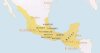
One other request: Generally, Mexico maps go all the way up to Rio Grande and stops right at the Yucatan peninsula. Now, for a Precolumbian Mesoamerica scenario, one doesn't need northern Mexico but one would need more of Central America, most importantly including Honduras.
here's a map showing the region:
Attachments
Yoda Power
✫✫✫✫✫✫✫
- Joined
- Sep 24, 2002
- Messages
- 13,870
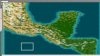
Originally posted by Nahuixtelotzin
Thanks, LuoLang, this will be an awesome map!
One other request: Generally, Mexico maps go all the way up to Rio Grande and stops right at the Yucatan peninsula. Now, for a Precolumbian Mesoamerica scenario, one doesn't need northern Mexico but one would need more of Central America, most importantly including Honduras.
here's a map showing the region:
like this?
Attachments
Similar threads
- Replies
- 5
- Views
- 4K
- Replies
- 6
- Views
- 1K
- Replies
- 44
- Views
- 3K
- Replies
- 1
- Views
- 585