Please post your proposals for defining the provinces here. The proposal that disorganizer is about to post is the official opinion of the domestic department.
- Home
- Forums
- OUR ARCHIVES
- List of Archived Forums
- Civilization III Archives
- Civ3 - Game of Democracy
- Civ3 Demo Game: Citizens
You are using an out of date browser. It may not display this or other websites correctly.
You should upgrade or use an alternative browser.
You should upgrade or use an alternative browser.
Provincial Borders Discussion Thread
- Thread starter eyrei
- Start date
disorganizer
Deity
- Joined
- Mar 30, 2002
- Messages
- 4,233
disorganizer
Deity
- Joined
- Mar 30, 2002
- Messages
- 4,233
Now the DDA-Proposal #1:
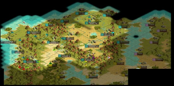
Ex-America is cut in half to create 2 provinces, surrounded by mountains. Istar stays as is, from the line Fox-Nest->Mountains->North. Another province will be appended to the south of Istar. The Egyptian Countries will be split on the south side of the Inland-Sea to create another province.
Ex-America is cut in half to create 2 provinces, surrounded by mountains. Istar stays as is, from the line Fox-Nest->Mountains->North. Another province will be appended to the south of Istar. The Egyptian Countries will be split on the south side of the Inland-Sea to create another province.
Attachments
disorganizer
Deity
- Joined
- Mar 30, 2002
- Messages
- 4,233
now to my private proposal:
see post below...
see post below...
Citizen_K
Warlord
...but Istar looks a wee bit small. What are we going to do with all those mtns. and desert? And how about, if we do keep it that small, calling it the Phoenatican Capital Province or something like that (I don't really like Istar that much)....
SKILORD
Insurgent
i like the 2nd proposal! 
disorganizer
Deity
- Joined
- Mar 30, 2002
- Messages
- 4,233
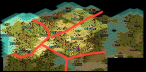
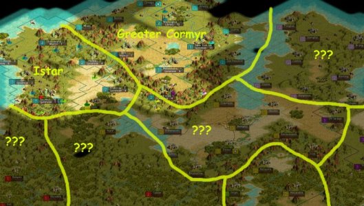
i put my proposal in a bigger context now... here is the result:
i posted it on a web-site in paint-shop pro format with layers for the map, names and the border here:
http://home.dinx.de/disorganizer/provinces.psp
general:
tried to base provinces on "valeys" and other geographical landmarks on the map. i threw away any city borders for this!
Istar:
our first province
reaches from fox-nest along the southern mountain range to the inland sea. then north along the eastern mountain range.
Greater Cormyr:
out second province
located east of Istar, this province covers the american valey and the mountain range to the east of it + the sea-cities east of the mountains. the southern border is the mountain range north of the inland sea
???:
yet to be named provinces
also located in valeys. i tried to share seas and oceans between provinces as much as i could.
Attachments
Shaitan
der Besucher
I like this second proposal. I'm very much in favor of following terrain features as it makes a natural looking province. This reminds me of the messed up county lines we have here in the Atlanta area. ")
The first proposal is based, I think, on the idea that we should have no more than 5 cities per province. If this is not the case, I like the second proposal much more.
Cyc
Looking for the door...
Very good Disorganizer. I like the map last edited 04/24 at 0231. The Greater Cormyr may be a little too big. Will you be putting it on a tile for tile border map? Or would you like some help doing that? If you need help, let me know.
disorganizer
Deity
- Joined
- Mar 30, 2002
- Messages
- 4,233
1.) i think greater cormyr is ok this way because there is so much desert in the middle and the "greater" must come to its some from somewhere... ;-)
2.) it would be nice if someone else could continue the fine-tuning of the map, as im going on vacation and will be buisy doing census and registration also... so if you like you can continue the map (but maybe we should find a professional mapmaker ;-) )
thats why i put the link to the original (1.3mb) paint-shop pro file (.psp) in the post to let someone else continue work with it. the psp has 3 layers: 1 with the raw map, 1 with the borders, 1 with the province names...
Originally posted by disorganizer
1.) i think greater cormyr is ok this way because there is so much desert in the middle and the "greater" must come to its some from somewhere... ;-)
2.) it would be nice if someone else could continue the fine-tuning of the map, as im going on vacation and will be buisy doing census and registration also... so if you like you can continue the map (but maybe we should find a professional mapmaker ;-) )
thats why i put the link to the original (1.3mb) paint-shop pro file (.psp) in the post to let someone else continue work with it. the psp has 3 layers: 1 with the raw map, 1 with the borders, 1 with the province names...
Istar is the one with the desert in the middle, not Greater Cormyr, which probably is too large. The northern area would make a good 3rd province, though it would contain probably exactly five cities. We could even call it Lesser Cormyr. We could then extend Greater Cormyr a little further south.
disorganizer
Deity
- Joined
- Mar 30, 2002
- Messages
- 4,233
wouldnt it be better to extend istar to the south? (i didnt because the governor of istar will also have work as domestic advisor, ->not to overload him). otherwise we maybe end with having 60 citizens, 10 leaders, 10 deputys and 40 governors, which i think doesnt make sense.
Cyc
Looking for the door...
Actually, my thought was running the eastern border of GC north through the mountains, putting NY in GC, and putting the coastal cities in with the egyptian province. That's where the desert is. Istar is doing very well here.
BTW, my 20/20 Freeware doesn't want to work with your paint shop pro.
BTW, my 20/20 Freeware doesn't want to work with your paint shop pro.
Originally posted by disorganizer
wouldnt it be better to extend istar to the south? (i didnt because the governor of istar will also have work as domestic advisor, ->not to overload him). otherwise we maybe end with having 60 citizens, 10 leaders, 10 deputys and 40 governors, which i think doesnt make sense.
I think your proposal for Istar is fine. It is Cormyr that I am worried about. In this manifestation, it will probably contain around 10 cities.
SKILORD
Insurgent
what's wrong with ten cities?
no that just wouldn't be right i suppose. *sigh*
no that just wouldn't be right i suppose. *sigh*
disorganizer
Deity
- Joined
- Mar 30, 2002
- Messages
- 4,233
would it help if i post the raw-map without borders+names as png?
or do you (cyc) want to create the map yourself?
ps:
im also for putting the coastal cities to the egyptian province.
or do you (cyc) want to create the map yourself?
ps:
im also for putting the coastal cities to the egyptian province.
disorganizer
Deity
- Joined
- Mar 30, 2002
- Messages
- 4,233
i just had an idea for a 3rd proposal:
only 5 provinces here:
the 2 provinces south of Istar are now one. the egyptian lands are expanded to the east and south. Greater Cormyr stays as it is (because the other border along the mountains just didnt "look" right)...
only 5 provinces here:
the 2 provinces south of Istar are now one. the egyptian lands are expanded to the east and south. Greater Cormyr stays as it is (because the other border along the mountains just didnt "look" right)...
Attachments
Falcon02
General
I think the Egyptian on could be cut in half, looks a little too big.
Cyc
Looking for the door...
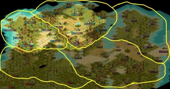
In this post, I would like to re-enter my original province map, dated 04/16/02, and the revised edition. In the newly revised editon, again, we are looking at provinces that govern 126 land tiles. This is basically equal to 5 independent cities with unobstructed borders and enough room mixed in for a 6th city (albeit scattered). This keeps us with the 5 city limit, but gives us a chance to grow independently. If the Governor decides to build densely-placed cities, it can be done. Pleasantly scattered coastal cities, it can be done.
The land features are pretty varied, with mountains, deserts, and plains. The Governor must use what they have and settle border disputes among themselves. Provinces 4 and 5 still need to be defined, but as the 126 land tile plan can be used perpetually, setting the outer borders will not be a problem (approved by cabinet vote?) Here is the original:

Here is the revised edition. note: when i resized the picture, the orange line along the southern shoreline duplicated. Ignore the second orange line.

The land features are pretty varied, with mountains, deserts, and plains. The Governor must use what they have and settle border disputes among themselves. Provinces 4 and 5 still need to be defined, but as the 126 land tile plan can be used perpetually, setting the outer borders will not be a problem (approved by cabinet vote?) Here is the original:
Here is the revised edition. note: when i resized the picture, the orange line along the southern shoreline duplicated. Ignore the second orange line.
Similar threads
- Locked
- Poll
- Replies
- 1
- Views
- 1K