- Home
- Forums
- CIVILIZATION IV
- Civ4 - Creation & Customization
- Civ4 - Project & Mod Development
- Civ4 - Rhye's and Fall of Civilization
- RFC mod-mod: Classical World
You are using an out of date browser. It may not display this or other websites correctly.
You should upgrade or use an alternative browser.
You should upgrade or use an alternative browser.
RFC Classical World
- Thread starter srpt
- Start date
Sorindafabico
Chieftain
- Joined
- Jan 22, 2008
- Messages
- 36
320 BC map games crash around 200 AD (I'm not sure about the exact turn). I'm playing the regular download (patched).
Changes in map are very interesting, Egypt became a very rich region.
Changes in map are very interesting, Egypt became a very rich region.
thrash4ever
Chieftain
- Joined
- May 12, 2012
- Messages
- 20
Just checked the latest version, it seems that due to China terrain being moved eastwards, the city names become invalid. Before we re-make the city name map, some further terrain adjustments need to be done. I saved the adjustment as the attachment, main points include:
Gansu corridor looks longer than before, a very good improvement. We need some narrow plains and oases in the area, also some resources need to added to support Han's Commanderies: Wuwei, Zhangye, Jiuquan, Dunhuang:
http://en.wikipedia.org/wiki/Hexi_Corridor
In Qinghai, the upper reach of Yellow river and Yangtse river need to be altered. In this map the upper Yangtse flows into Mekong, that is an obvious mistake.
Nanzhao has a big lake, which is too exaggerated. The area (equal to Yunnan province today) has some lakes but most of them are too small to be put in this map. Also, the area has more plains in the east than in the west:
http://en.wikipedia.org/wiki/Yunnan
It makes more sense to have 2 tiles of plain in the eastern area to support Han's Yizhou Commandery, and one plain in the western (near Mekong) to support later Yongchang Commandery.
One more plain needs to be added southeast of Xianyang, representing Hanzhong basin (Hanzhong the name indicates the river Han), an important link between Xianyang and Shu. Some more impassible forests should be put around the area, but still allowing passage by some valleys.
Luoyang terrain needs some change, one tile of plain in its west, one hill in the east and one hill in the south should better present the nature of this area as a small basin.
Peaks around Jinyang should be relocated, also rivers around the city should be adjusted. Sanggan-Yongding river should be added due to its importance as the seat of Xianbei's capital Pingcheng:
http://en.wikipedia.org/wiki/Pingcheng
More impassible forests south of Huai river, which represents the mountain Dabie:
http://en.wikipedia.org/wiki/Dabie_Mountains
The area where river Han joins Yangste should be populated with more hills and an iron/bronze nearby, the area has been the center of bronze mining since Shang Dynasty. Jiangxia Commandery existed here in Han Dynasty, later Sun Quan built Wuchang (current Ezhou) here:
http://en.wikipedia.org/wiki/Ezhou
Throughout the history of the state of Wu, Wuchang has been the second capital, accompanying Jianye.
The city of Jianye should be removed. 1. It's at the wrong place. 2. The city didn't exist until 211 AD:
http://en.wikipedia.org/wiki/Nanjing
It makes sense to make it spawn in 211 AD, also at the beginning of the 220AD scenario, the location being further east to the Yangtse river bend, as you can see from the map of Nanjing.
Min Yue should stop renaming itself to 'Fuzhou' when Qin, Han or Jin captures it. Qin should rename it to 'Minzhong', Han or Jin to 'Dongye'. The city was not renamed to Fuzhou until 725 AD:
http://en.wikipedia.org/wiki/Fuzhou
More impassible forests around the city should represent the Wuyi mountains, more fish at its coast, more timber, tea.
More hills to the north of Panyu-Nanhai, more plains in western Nanyue (current Guangxi province), one pearl near the coast, ivory near Vietnam to lure Qin to build Guilin and Xiang Commanderies.
More impassible forests at the source of the river Liao:
http://en.wikipedia.org/wiki/Liao_River
More hills and forests east of Liaodong, and more plains in lower Yalu/Amnok river. This is to make Guknaeseong (Gungnae Fortress) a better place for Goguryeo to spawn up in 3 AD:
http://en.wikipedia.org/wiki/Gungnae_Fortress
This makes it more difficult for Chinese troops to go from Liaodong to attack Goguryeo, quite realistic.
Gojoseon relocated to Wanggeomseong, which should be renamed 'Lelang/Nakrang' when captured by Han:
http://en.wikipedia.org/wiki/Lelang
Lelang has been kept by Chinese since 108 BC until Goguryeo conquered it and renamed it to 'Pyongyang' in 313.
Heilong/Amur river and Nen river in Manchuria:
http://en.wikipedia.org/wiki/Heilongjiang_River
http://en.wikipedia.org/wiki/Nen_River
Greater Khingan mountains in Manchuria should be put further west:
http://en.wikipedia.org/wiki/Khingan_Mountains
In Xinjiang, Tian Shan mountains needs overhaul:
http://en.wikipedia.org/wiki/Tianshan_Mountains
Upper Ili river and Ili valley should be represented:
http://en.wikipedia.org/wiki/Ili_River
Spices and Grapes near Tarim river to allow Tocharian states to trade with Han.
You can see all above changes in the file attached, when you're finished, I can provide new city name map.
Attachments
those changes look good. it will take me a few days to implement them over the 4 maps though.
about cities:
which cities should be present in 320BC and when should the other important ones spawn?
and what is the best city setup for the 3 kingdoms period?
about cities:
which cities should be present in 320BC and when should the other important ones spawn?
and what is the best city setup for the 3 kingdoms period?
thrash4ever
Chieftain
- Joined
- May 12, 2012
- Messages
- 20
I can only give you this for 320BC scenario.
For the city setup in other scenarios, I think it's better to wait until all terrains are adjusted, because things are more complicated.
For example in the 80BC scenario, I cannot play as Han, but need to wait until Wei pops up, quite strange isn't it?
80BC was the time when the Western Han Empire was in its prime, the empire stretched from Inner Mongolia to central Vietnam, from Ferghana to Korea.
Anyway, in this file I already added the starting cities for 320BC, and some later cities with the pop-up time. Also noted the comments on the altered rivers or hills. Rivers in Manchuria are further improved, upper Pearl river is adjusted.
Attachments
@ thrash4ever: open the 80BC WBS and find the entry for the Han. change "playable civ" from 0 to 1.
@ Sitalkas: I was trying a new method for randomized spawn dates but its obviously problematic. I put it back to the old method in this rev (202) (btw you meant Numidians, right?)
@ Sitalkas: I was trying a new method for randomized spawn dates but its obviously problematic. I put it back to the old method in this rev (202) (btw you meant Numidians, right?)
ooops ! Yeah Numidians !
Great , updating it now!
edit:
I have noticed lately that Meroe have become quite overpowered.. they always conquer Egypt and grow high in score
also I discovered a bug, when I change civics I dont get anarchy turns! (which is ok if you ask me )
)
Great , updating it now!
edit:
I have noticed lately that Meroe have become quite overpowered.. they always conquer Egypt and grow high in score
also I discovered a bug, when I change civics I dont get anarchy turns! (which is ok if you ask me
)Sorindafabico
Chieftain
- Joined
- Jan 22, 2008
- Messages
- 36
also I discovered a bug, when I change civics I dont get anarchy turns! (which is ok if you ask me
Same here (regular download).
CrossRFC
Emperor
- Joined
- Jul 21, 2008
- Messages
- 1,273
Same here (regular download).
Not sure if bug or intended behavior...
Rod
King
I just played a campaign as Gupta (Scenario 220 AD) on Emperor
The scenario starts in 220 AD, the Gupta start in 320 AD and until 475 AD neither the Vakatakas (Deccan) nor the Kalabras (Tamil Nadu) moved beyond their first city.
This is despite the fact that both had at least 2 independent cities nearby for all the time.
I actually pinpointed the issue a little more. At the beginning of the scenario, 220 AD, Vakatakas, Kalabras and Kalingas are all supplied with at least 2 cities. This situation has not changed by 250 AD (Japanese spawn). However in 320 AD (Gupta spawn) all of these civs are holding only 1 city.
There is one more issue. It seems that in 220 AD the West of India is held by Hephthalites. This is very odd as the Hephathalites are not supposed to invade India before the 5th century. (in game there are actually coded invasions at several time points in the 5th century)
Moreover I think the settler maps are messed up. The Kushans founded Lavapuri just one tile to the right of the spot where both Sorghum and Citrus would have been in the cross. The Vakatakas founded Gwalior just one tile right of the spot where Hemp would have been within the cross.
Besides I can not always raze a city on conquest. E.g. I could not raze said Lavapuri. but later I could raze Gwalior.
This is not all, though.
East Asia is a mess. Shortly after meeting them the Vietnamese collapsed leaving behind a trail of independent cities. The Kambujas were not able though to move beyond 3 cities, basically they just took Angkor and stopped expanding.
But most concerning is the situation in China. The Wu have survived but stuck on only 2-3 cities. The rest of China is independent and Ji is Barbarian. Changa'an is held by the Antigonids ?!? who most probably respawned. But also the Antigonids did not move beyond Changa'an.
The West looks at least civilized but also static. Meaning, the Byzantines are the powerhouse, the Sassanids are powerful , but there is absolutely no movement. Everybody just seems to keep his cities, but not settling, nor conquering.
Last but not the least. When I am switching civics then I don't always experience anarchy
I have a question about religious displacement. I can see that with Christianity it has been frequently replacing Hellenism. Is displacement only during the religion's spread or does it have an over time effect? Like when Hellenism isn't replaced, does it disappear over time from Christianity or Islam's presence?
Also, it says to control 6 provinces in 250AD for Dacia but it activated as if it were by 250AD. I've seen frequently where on the victory screen it would say like Get 18000 gold by this time but under it, it would say (amount of gold)/12000. I've seen it for Bactria and Dacia.
Also, it says to control 6 provinces in 250AD for Dacia but it activated as if it were by 250AD. I've seen frequently where on the victory screen it would say like Get 18000 gold by this time but under it, it would say (amount of gold)/12000. I've seen it for Bactria and Dacia.
sorry the mod is so buggy right now. I think some of the settler maps have indeed become off somehow. that could explain the do-nothing AI. the Antigonids respawn as the Rouran so thats probably why they were in Chang'an. don't know why their identity switch didn't happen but I will look into it.
I haven't had that much time lately and what I have had has gone into improving China again.
I did however have a cool idea last night and got it to work this morning: trade route and great people bonuses for close together cities.
I've always thought there should be some way to allow closely packed cities to be a strong option in historical maps since there were always places where the cities needed to be close together to get all the important cities in.
I'm going to give cities 1 extra trade route for every other city of size 3 or more within three tiles of that city and +10% great people for every size 6 or larger city in that range. I will reduce overall great people and increase city maintenance to balance it. a culture bonus is also possible.
I have some time today and this weekend so I will try to get the map and the settler maps together quickly.
about the religion replacement, it just checks when the religion is spread and periodically thereafter.
the gold count discrepancy is from epic speed. I will look into it.
DC123456789
Deity
Have you taken a look at the Dacian settler map I posted earlier?
latest revision, Byzantine game
I can't declare war on Rome, that means I cant conquer areas required for UHV.
Seleucids spawn alongside the Huns, with heavy horse archers
Huns are called "The kingdom of Numidia" , leader is Mansa Munsa from vanilla
Antigonids spawned in China!
I will post a screenshot with some suggestions regarding the Greek landscape!
Has anyone won with Kambuja's UHV? I could see it being possible if the covering Funan with culture's date was switched with the one for the technologies. I don't know if I'm just not doing it right or what. There isn't much production in the province so the only buildings i have been able to construct were the religious buildings after i got villages to help with production, but by then it seems too late for libraries to help much. I got to 250 AD with Crop Rotation, Philosophy, and Monasticism left and theres no way I'm going to get that.
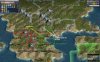
OK, so here are my suggestions for Greece. I've also included some city names that fit better in my opinion.
I used this pic as a reference

about the resources :
I moved olives in western Attica, even nowadays it is full of olives and generally there have ever been there. Marble on the other side of Athens is pretty historical too, there were many mines and excavation sites there.
Larissa valley, a huge bonus to who ever controlling it. Horses and wheat. The horse is the city's trademark and the wheat represents the valley's output. Even nowadays it feeds half of Greece!!
Some silver north of Pella, maybe replace it with a gold ore.
Forests in the Peloponese and in Crete. Perhaps move the forest in crete 1E to represent a famous national park
EDIT: after some research, replace Iolkos with Demetrias.
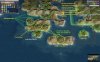
When under Byzantine control:
Sparta -> Mystras
Argos -> Nafplio
Olympia -> Elis
Mantineia -> Tegea
for North part I will create another map with Byzantine names. i ll use this link as a reference http://en.wikipedia.org/wiki/Theme_(Byzantine_district)
I used this pic as a reference
Spoiler :
about the resources :
I moved olives in western Attica, even nowadays it is full of olives and generally there have ever been there. Marble on the other side of Athens is pretty historical too, there were many mines and excavation sites there.
Larissa valley, a huge bonus to who ever controlling it. Horses and wheat. The horse is the city's trademark and the wheat represents the valley's output. Even nowadays it feeds half of Greece!!
Some silver north of Pella, maybe replace it with a gold ore.
Forests in the Peloponese and in Crete. Perhaps move the forest in crete 1E to represent a famous national park
EDIT: after some research, replace Iolkos with Demetrias.
When under Byzantine control:
Sparta -> Mystras
Argos -> Nafplio
Olympia -> Elis
Mantineia -> Tegea
for North part I will create another map with Byzantine names. i ll use this link as a reference http://en.wikipedia.org/wiki/Theme_(Byzantine_district)
Attachments
CrossRFC
Emperor
- Joined
- Jul 21, 2008
- Messages
- 1,273
OK, so here are my suggestions for Greece. I've also included some city names that fit better in my opinion.
I used this pic as a referenceSpoiler :
about the resources :
I moved olives in western Attica, even nowadays it is full of olives and generally there have ever been there. Marble on the other side of Athens is pretty historical too, there were many mines and excavation sites there.
Larissa valley, a huge bonus to who ever controlling it. Horses and wheat. The horse is the city's trademark and the wheat represents the valley's output. Even nowadays it feeds half of Greece!!
Some silver north of Pella, maybe replace it with a gold ore.
Forests in the Peloponese and in Crete. Perhaps move the forest in crete 1E to represent a famous national park
EDIT: after some research, replace Iolkos with Demetrias.
When under Byzantine control:
Sparta -> Mystras
Argos -> Nafplio
Olympia -> Elis
Mantineia -> Tegea
for North part I will create another map with Byzantine names. i ll use this link as a reference http://en.wikipedia.org/wiki/Theme_(Byzantine_district)
The tile between Macedonia and Greece proper should stay a hill, because it slows down invaders coming into Greece without a road. It's roughly near Mt Olympus anyhow.
Similar threads
- Replies
- 12
- Views
- 1K
- Replies
- 2
- Views
- 298
- Replies
- 3
- Views
- 792