Solution: The Globe in Civ V, a really spherical map with only hexagonal tiles!

Status
Not open for further replies.
BY THE POWERS OF NECROMANCY, I COMMAND THIS THREAD TO RISE FROM ITS GRAVE!!

*ahem* So anyway.

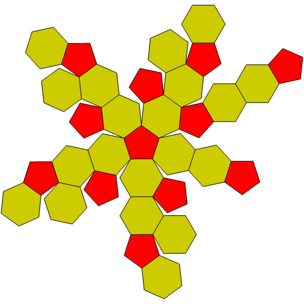
As this thread has clearly established, it is definitely impossible to tile a sphere using nothing but hex tiles. But I'm currently devising a way to circumvent this problem, and create a spherical world that restricts all land movement to hex tiles. I won't go into details here; I'll save it for my own thread once I've finished working out everything.

However, before I proceed, I need this question answered:

You have a sphere, and you have a grid of hexagons.
1.) The grid itself must be a convex shape (after smoothing out the zigzagging edges, of course.)
2.) All hex tiles, except for those on the border of the grid, should have six neighboring tiles.
3.) The hex tiles can squash and stretch, but not to a greater extent than they do in Orthoceros' models.
4.) The hex tiles cannot overlap.

Given all of that, how large of a grid can you wrap around a sphere, and how much of the sphere can you cover with such a grid, before one of the above rules must be broken?

(If the answer is greater than 50%, then that's a very positive sign.)
 
BY THE POWERS OF NECROMANCY, I COMMAND THIS THREAD TO RISE FROM ITS GRAVE!!

I'll join in on a little necro! Wait, that definitely doesn't sound right. :nono:

Anyway. I also think that using a subdivided icosahedron, made up almost entirely of hexagons but with 12 pentagons, is a good way to go. The one catch would be if the 12 pentagons became unmanageably "special" because they only had five sides instead of six.

This could be an issue if cell spaces in general had a max unit count; or if folks tended to protect special locations by surrounding them with a jelly-donut-like ring of defenses (i.e., only spreading defenses over 5 neighboring hexes rather than 6); etc. But I wouldn't want to stop an otherwise good map representation over that.

Anyway, if anyone was curious a while ago I cooked up some Java to render a flat map of a geodesic sphere. To make it a flat map, as the hexes get nearer to the poles they get increasingly distorted... if the map was rendered using 3D graphics on a sphere, you could display a 'local' portion and everything would look correctly proportioned. :)

The original use case was a custom map for a board game, so the images were uploaded to BoardGameGeek. See:

pic214279_md.jpg


More (larger) sizes can be found at BGG

The board was layered in Photoshop, with the world map as the background, the hexes as a layer, and the various labels and such as additional layers. The file which was used to actually print out the board was 10,800px by 5,400px... so @ 180dpi, it came out as a glorious 5' x 2.5' surface. :D
 
spherical maps - I would like that just because all the earth maps have way to much Russia and Canada atm, and not enough central America, India, Indonesia etc. etc. Even if the poles themselves don't add much.

I think the idea of an icosahedron with 12 pentagon vertices would be easier for the programmers to make work (graphically easier, new distance algorithms comparatively easier to alter (I'm programmer, this is just a guess)), and generally just be easier for the layman (me) user to understand; the 6 poles originally mentioned seem weird cos there are 4 tiles which are all simultaneously adjacent, not the same as a standard tiling.

I also like the look of the map a couple of posts above, which doesn't have the poles themselves but gets close and adjusts the tiling to make paths near the poles shorter. It reminds me of hyperbolic geometry in the half plane (which would not require different tiles or adjacencies, and which may provide similar results). Is this in any way related / anyone any ideas how to use it and make it work? It'd need you to stick 2 together around the equator, and also to cut a bit off the bottom edge off as the real hyperbolic model goes off to infinity. I wonder if there's a way of sticking two tessellations together in this way (such as e.g. a pentagonal tiling with 4 tiles at each vertex).

However, I think it'd be much more fun to expand this by using some of the cooler 2-manifolds, which would not require any graphical work at all, (and no algorithm work too, I imagine); I want to play on a Klein bottle or RP^2!
 
I think the idea of an icosahedron with 12 pentagon vertices would be easier for the programmers to make work (graphically easier, new distance algorithms comparatively easier to alter (I'm programmer, this is just a guess)), and generally just be easier for the layman (me) user to understand; the 6 poles originally mentioned seem weird cos there are 4 tiles which are all simultaneously adjacent, not the same as a standard tiling.

I know this is an old thread but I have some insights to add.

You are correct. An icosahedron would be easier. Drawing overlapping hexes would be a real pain for texturing. Drawing hexes and pentagons would not be and could be done one of two ways.

  1. Have two sets of graphics - one for pentagons and one for hexagons
  2. The easier way though would be to base all hex graphics on triangles rather than a complete hex. The triangles could then be scaled to any given tile.

Basing drawing on triangles would also rid of the need for so many restrictions we have had in the past. For example, a river could be between tiles or go through the tile itself.

Of course there would be some costs as well. I have actually created such a grid in a computer program. Here is a list of basic problems.
  1. If drawing algorithms are going to be based on 2 coordinate triangle strips (the third coordinate provided by the last point in the previous triangle), then the method for calculating the triangle order becomes incredibly complex, especially if the grids must be divided using numbers other than 2 (when subdividing the 20 basic triangles that make up the icosahedron). Of course these are only available in DirectX so it may not matter.
  2. Things like lowering/increasing detail in the drawing of the planetary surface can be more complicated
  3. There is no convenient array to easily look up plots by coordinates since the hexes do not follow a consistent orientation throughout the grid. The only way to do this is to set up a custom made hash/indexing table that is able to use latitude and longitude (or similar coordinate system) as components for a key used to look up the correct plot.
  4. The fact that a coordinate system cannot be used means that each plot would have to be linked to its neighbors in memory. This would require 5-6 extra pointer addresses per plot. If direction was also important, that information would also need to be stored or somehow standardized, requiring potentially another 5-6 floating point numbers representing direction. This expands the memory needs for maintaining an easily navigated map. That is a minimum of 120 bytes per plot. It doesn't sound like much but it adds up. Memory necessary for a single grid of 9600 plots storing directional data would be at least 1,382,400 bytes which is 18 times the amount of look-up/grid space needed (76,800 bytes) if using ordinary hex or square plots in an array.

I am not trying to discourage the development of such a map, it is just helpful to know what is involved and the downside.

NOTE: The above numbers assume 64 bit memory addresses. If 32 bit memory addresses are assumed, the game is limited to 2GB of memory.
 
Some of the problems with icosahedron sphere (geodesic grid) :

- the pentagons and hexagons share the same edge (same length) and therefore the pentagons are always smaller than the hexagons (cover a smaller area).
- You cannot use an isometric view of the "flat" map when one or more pentagons are displayed. The pentagon(s) will always lead to a deformation of the neighbouring hexagons ...


see also http://forums.civfanatics.com/showthread.php?t=354148 for an older discussion
600px-Truncated_icosahedron_flat.png


You may also want to look at http://freeciv.wikia.com/wiki/Sphere, http://freeciv.wikia.com/wiki/Talk:Sphere

180
 
Might be a silly question but do there have to be tiles at all?

Units move around ok on RTS maps, and bases can usually be more-or-less placed anywhere. 3d or 2d view of a planet are easy. There never seems to be any problem pathfinding, and those games are recalculating many times a second for tons of units, not once a minute for a handful. There/s no stacking/1upt argument because the units just crowd as close as they physically can and that's it. You can multi-select and make groups - what's not to like?

Off the top of my head I can't see an obvious reason why a TBS game wouldn't work with that kind of map? Is it assumed that decent AI would be too hard to code?
 
There are RTS games and turn-based, tile-based strategy games. Turns and Tiles are the result of discrete time and space which allows simpler rules for a complex game. Civ1 - Civ5 are all turn-based games while Age of Empires or Rise of Nations from Big Huge Games are kind of RTS-Civ-games.

(RTS games also use discret time and space but maybe 100-1000 times smaller than TBS turns and tiles.)

Example :
Every tile has a specific terrain type (e.g. grasland) and may hold one or more units. In a non-tile-based game, a unit may be half on grasland and half in a forest which makes combat and movement rules more complicated, in a tile-based game the terrain-type of a tile is always well defined.

There are pros and cons for RTS and turn-based games. Civ-Players probably enjoy that they can take their time when planning their turns while RTS-games usually are more fast-paced. The map grid adds structure. Due to the discret time and space, it is easier to evaluate different actions, while in a RTS game there are much more possible actions due to continuos time and space. (e.g. when placing a unit in tile A or B in TBS (2 cases), in RTS you might place the unit in an area of 100 x 50 pixel around point x,y (5000 cases) which results in much more possible coordinates to evaluate as the 2 tiles.) In a TBS game you can compare different "combinations" of discret actions for single turns (= fun for many players), in RTS it is harder to do so ...
 
Yes RTS vs TBS there's a clear difference - I prefer turn-based myself, I was just struggling to see why that also has to mean tile-based.

None of what you said seems a deal breaker really - I mean e.g. for unit terrain simply use the terrain at the unit centrepoint, or more realistically award e.g tree cover according to how well into the trees it is! Also you then get the possibility to have units partway up a hill and get elevation bonus accordingly, rather than just being on a hill or not on a hill and all hills in the world are the same height!

The one point you said though about players liking to consider discrete choices, and combinations of choices rings true - I'm like that! I don't want it to be overwhelming at all - I like a simple system like civ has. Even so we do see rather a lot of the same people in threads like this complaining about lack if realism in one aspect or other of the units/combat system - seems to me tiles are the least realistic thing of all :-)

I wonder has anyone ever made a TBS with no tiles? The tabletop games I used to play with my brother with plastic soldiers and rulers and calculators were turn-based with no tile system and that was great fun :thumbsup: I think the design problems of making it simple and approachable in a videogame TBS might not be as huge as you think. Certainly not as insoluble as tiling a sphere with just hexagons :lol:
 
Computers are digital NOT analog.

The TBS games in question actually do have tiles, it's just massive (on the edge of human resolution)
 
The torus map from civ4 is actually a sphere, without ice caps.

People who call a map wrapped N|S & E|W a torus are missing the main point of a sphere. There is no top or bottom on a sphere. No ends!
Just imagine that a "so called torus map" is your palm, north pole is your middle fingers, left side of minimap is index finger, right side is little finger. Now connect them together, and now you see that when going to north pole you end up coming from south pole.
Imagine a sphere made up of many rectangular sheets stuck together with overlapping edges.
You think of top and bottom of the minimap as two different poles, but actually it's only one divided in two by our perception, socond pole is in the center of the minimap

A torus is NOT a sphere

While it is similar in that they have no edges, the movement is still very different.

In particular, the area is different near the poles.

Might be a silly question but do there have to be tiles at all?

Units move around ok on RTS maps, and bases can usually be more-or-less placed anywhere. 3d or 2d view of a planet are easy. There never seems to be any problem pathfinding, and those games are recalculating many times a second for tons of units, not once a minute for a handful. There/s no stacking/1upt argument because the units just crowd as close as they physically can and that's it. You can multi-select and make groups - what's not to like?

Off the top of my head I can't see an obvious reason why a TBS game wouldn't work with that kind of map? Is it assumed that decent AI would be too hard to code?

some of it is the area issue

resources come from terrain, terrain has area, and it needs to be divided as such.
 
I wonder has anyone ever made a TBS with no tiles? The tabletop games I used to play with my brother with plastic soldiers and rulers and calculators were turn-based with no tile system and that was great fun :thumbsup: I think the design problems of making it simple and approachable in a videogame TBS might not be as huge as you think. Certainly not as insoluble as tiling a sphere with just hexagons :lol:

we played soldiers with rulers and dices too :)

i agree the need for tiles is somewhat overestimated. devs should just invent some new design approaches to the new game type.
 
resources come from terrain, terrain has area, and it needs to be divided as such.
I'm not sure this follows really. E.g. if each citizen in a city allows the city to work 1 hectare of land near the city, there's no reason that hectare needs to be any particular shape. In the real world farm fields, forests etc. aren't regularly shaped. An iron deposit or whatever need not be regularly shaped on a TBS map IMO. The map generator might even make sure resources always appeared at least in multiples of 1 hectare but no specific shape, and that would make things even simpler. Or maybe it could be a smaller deposit, or if a city could only reach half of it, well then you could only collect half a resource, or get half the :hammers: bonus, or whatever the benefits were. Doesn't seem too bad - the map would surely look much more natural than a tiled one, as well as there being interesting tactical possibilities where maybe a resource is in a long thin seam with you owning half and your neighbour owning half :devil:
 
Anyone got any idea if Civ VI is implementing this?

I am almost completely sure it doesn't, because if it did it'd be change similarly revolutionary to hexes of civ5 and it'd be among the first announced features.

Personally I also think, while the globe itself would be very cool, even if we exclude geometrical/graphic issues, there is another problem:

there are a lot of map types in civ series and most of them aren't possible to be displayed on the globe.

I mean: Earth map, or continents, or pangea, or archipelagos - ok, globe. But in civ5 such maps as "Europe" or "Middle Earth" were very popular, not to mention less popular but available at default types such as 'south vs north' '100% land map' etc.

So, either they are impossible to be done with globe (this would be much worse than lack of the globe IMO) or devs have to put a lot of job in the globe, only for it to be not used half of the time.

In general I think globe itself would be cool, but it'd require too much work which could be better invested in more vital features of a game.
 
There's still hope that it can be modded in, or that it will be introduced in an Add-On or DLC.
 
There's still hope that it can be modded in, or that it will be introduced in an Add-On or DLC.

I'm extremely skeptical, I mean, this would be very radical change to the entire structure of maps. In civ5 graphic engine didn't allow on seemingly small feature of ability to change base terrain (to the extent devs themselves were unable of making Polders turn sea into land and had to leave this idea), so if civ6 engine wouldn't have globe by default I don't think this could be simply 'added', especially by modders who in the past were limited by much smaller hardcoded boundaries.
 
This might be a dumb or impossible idea but felt i had to put it out there

couldnt mountain ranges simply be put over these poles rendering their (dis)advantages moot anyways? it might be a cheap cop out but there would finally be a globe map

a final idea, would it be possible to tessellate the map with a variety of shapes to the point that all regions contain a mixture of different polygons. this would add a new element to the game and if there aren't only a very few amount of these points, but instead the mixture makes the whole map, then the games fair right?

i dont understand why this is being limited to just hexagons when pentagons and hexagons together are much better at making spheres without the problems of overlap
 
Last edited:
Status
Not open for further replies.
Back
Top Bottom