amrod
Warlord
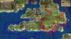
I'm getting suicidal with this map..just when I thought it was good enough, I discovered a bunch of misaligned parts  , then I coulnd't reproduce the same zoom I did before (as I messed with the xmls - the default zooms of the map are from an angle and thus are useless to make a concatenated screenshot map).
Anyone care and can explain to me *in detail* (that is, about all of numbers) what these things do (as I didn't find good info on the net yet):
<Name>DF_DETAIL</Name>
<Key>700, 0.00</Key>
<Key>750, 1.00</Key>
<Name>DF_SKY</Name>
<!-- Rhye - start -->
<Key>8000, 0.00</Key>
<Key>8000, 1.0</Key>
<Key>%CAMERA_MAX_DISTANCE, 1.00</Key>
<Name>DF_GLOBE_TERRAIN</Name>
<Key>7000, 0.00</Key>
<Key>7400, 1.00</Key>
<Name>DF_GLOBE_MORPH</Name>
<Key>7400, 0.00</Key>
<Key>%CAMERA_MAX_DISTANCE*0.97, 1.00</Key>
, then I coulnd't reproduce the same zoom I did before (as I messed with the xmls - the default zooms of the map are from an angle and thus are useless to make a concatenated screenshot map).Anyone care and can explain to me *in detail* (that is, about all of numbers) what these things do (as I didn't find good info on the net yet):
<Name>DF_DETAIL</Name>
<Key>700, 0.00</Key>
<Key>750, 1.00</Key>
<Name>DF_SKY</Name>
<!-- Rhye - start -->
<Key>8000, 0.00</Key>
<Key>8000, 1.0</Key>
<Key>%CAMERA_MAX_DISTANCE, 1.00</Key>
<Name>DF_GLOBE_TERRAIN</Name>
<Key>7000, 0.00</Key>
<Key>7400, 1.00</Key>
<Name>DF_GLOBE_MORPH</Name>
<Key>7400, 0.00</Key>
<Key>%CAMERA_MAX_DISTANCE*0.97, 1.00</Key>

")